Zana Khan District
Zana Khan district is a mountainous district in Ghazni Province, Afghanistan with more than 12,000 people living there (100% Pashtun).[2] The district center is Dado.
Zana Khan
زنهخان | |
|---|---|
District | |
 Zana Khan Location within Afghanistan[1] | |
| Coordinates: 33°41′N 68°40′E | |
| Country | |
| Province | Ghazni Province |
| Population (2002)[2] | |
| • Total | 12,230 |
The district is within the heartland of the Andar tribe of Ghilji Pashtuns.[3] Continuing drought is the main problem as in the whole province. It seriously affects agriculture, the main source of income. Health and education services need serious improvement.
Agriculture
Land condition in 2002 found 20% of arable land in use.[2]
- Main crops: wheat, alfalfa, maize and barley.
- Animal husbandry: sheep, goats and cows.
See also
External links
- Map of Settlements AIMS, May 2002
References
- "District Names". National Democratic Institute. Retrieved 12 November 2015.
- "District Profile" (PDF). UNHCR. Retrieved 12 November 2015.
- Ghazni Province Tribal Map (Page 4). Naval Postgraduate School.
| Districts | 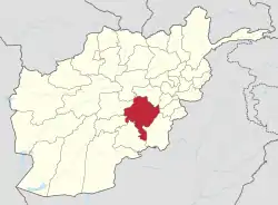 | |
|---|---|---|
| Populated places |
| |
| Landforms | ||
| Other | ||
This article is issued from Wikipedia. The text is licensed under Creative Commons - Attribution - Sharealike. Additional terms may apply for the media files.