Zelienople, Pennsylvania
Zelienople /ˌziːliəˈnoʊpəl/ is a borough in Butler County, Pennsylvania, 28 miles (45 km) north of Pittsburgh. The population was 3,812 at the 2010 census.[4]
Zelienople, Pennsylvania | |
|---|---|
| Borough of Zelienople | |
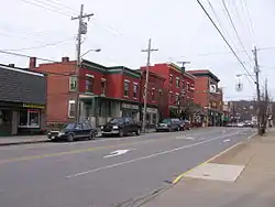
 Downtown Zelienople | |
| Nickname(s): zelie | |
| Motto(s): A Modern Place with Old Fashioned Grace | |
 Location of Zelienople in Butler County, Pennsylvania. | |
.svg.png.webp) Location of Pennsylvania in the United States | |
| Coordinates: 40°47′31″N 80°8′28″W | |
| Country | United States |
| State | Pennsylvania |
| County | Butler County |
| Township | Jackson Township |
| Settled | 1802 |
| Incorporated | 1840 |
| Government | |
| • Mayor | Thomas M. Oliverio |
| Area | |
| • Total | 2.10 sq mi (5.44 km2) |
| • Land | 2.05 sq mi (5.32 km2) |
| • Water | 0.05 sq mi (0.12 km2) |
| Population (2010) | |
| • Total | 3,812 |
| • Estimate (2019)[2] | 3,603 |
| • Density | 1,754.99/sq mi (677.65/km2) |
| Time zone | UTC-5 (EST) |
| • Summer (DST) | UTC-4 (EDT) |
| Area code(s) | 724 Exchanges: 452,453 |
| FIPS code | 42-87272 |
| School District | Seneca Valley school district |
| Website | zelieboro |
| Designated | October 3, 1947[3] |
Geography
Zelienople is located in southwestern Butler County, situated on the south bank of Connoquenessing Creek, in an area that is rich with coal and iron ore. The elevation is 935 feet (285 m) above sea level. The borough is bordered by Jackson Township on the north, southeast, and south, and by the borough of Harmony on the northeast. The western border of Zelienople is the Beaver County line.
U.S. Route 19 (Perry Highway) is the main north-south road through the center of town. Interstate 79, running generally parallel to US 19, passes just to the east of the borough, with access from Exits 85, 87, and 88. Via I-79 and I-279 it is 28 miles (45 km) south to downtown Pittsburgh. To the north I-79 leads 100 miles (160 km) to Erie. Pennsylvania Route 68 runs east from US 19 as East Grandview Avenue and southwest as West Beaver Street. Via PA 68 it is 17 miles (27 km) east to Butler, the county seat, and 12 miles (19 km) southwest to Rochester on the Ohio River. Routes 288 and 588 lead west from town on West New Castle Street, PA 288 turning northwest to lead 10 miles (16 km) to Ellwood City, and PA 588 leading 14 miles (23 km) west to Beaver Falls.
According to the United States Census Bureau, the borough has a total area of 2.1 square miles (5.4 km2), of which 0.04 square miles (0.1 km2), or 2.20%, is water.[4]
History
_by_Anton_Graff_(1736_-_1813).jpg.webp)
Zelienople was named for the eldest daughter of Baron Dettmar Basse (1762–1836), whose chosen name was Zelie (her given name was Fredericka) which she named herself after her favorite doll.[5] Baron Basse arrived in 1802 from Frankfurt am Main, Germany, and purchased a tract of 10,000 acres (40 km2) of land in Butler and Beaver counties.
He proceeded to lay out a village and build his own private residence, a three story castle, complete with towers, turrets and battlements, named "The Bassenheim",[6] which was destroyed by fire on July 29, 1841. At the time, Zelie was betrothed to Philip Louis Passavant, and was still in Germany. Extensive preparations were made by Baron Basse to establish the new home and town in America and prepare it for his daughter's arrival in September 1807.
Baron Basse sold 5,000 acres (20 km2) of his land to George Rapp, a Bavarian pietist religious leader, who founded the village of Harmony. Baron Basse came to be known as "Dr. Muller". Whether the title of "Doctor" was given to him due to a knowledge of medicine, or conferred upon him as a degree, is unknown. He was regarded as an intelligent man, and during the Napoleonic era represented Frankfurt as an ambassador to Paris. Basse returned to Germany in 1818, leaving his business to his son-in-law, Philipp Passavant.
Philip Passavant opened the first store in 1807, and managed it for 41 years, until he gave it to his son, C. S. Passavant. By 1826, there were fifty houses in Zelienople, and three churches. The population in 1870 was 387, and in 1890, it had grown to 639. In 1879, the first passenger train arrived to the town, substantially increasing the growth and commerce. In 1880, the American Union Telegraph Company established an office in Zelienople. The Federalists appointed Andrew McClure, a local tavern-keeper, as the first postmaster of Zelienople in the first decade of 1800. Christian Buhl was named the first justice of the peace in 1840.[7]
Early Zelienople commerce supported the local agriculture community, as there was no viable means of transportation. In 1840 Zelienople was incorporated as a borough. In 1878 a railroad was built through Zelienople. From this time there has been moderate expansion of industry, residences, and local government. There has been a volunteer fire department since about 1850. A full-time Borough Manager was hired in 1994. The growth of Pittsburgh to the south, along with the building of Interstate 79, provides a challenge to Zelienople in coping with these changes through the 21st century.[8]
Zelienople was linked to Ellwood City, Evans City and Pittsburgh in 1908 by the Pittsburgh, Harmony, Butler and New Castle Railway, an interurban trolley line. The line closed on 15 June 1931, and the trolleys were replaced by buses. Zelienople is also known for its historical Eichholtz Building. The Eichholtz family played a historical and transformational role in Zelienople.
Culture and events

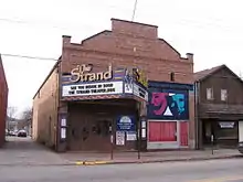
Every year, Zelienople hosts a Fourth of July parade through downtown. The Strand Theater is a performing arts center on Main Street that has been restored, and hosts concerts and films for the borough and surrounding area.
For the past 44 years, one of the major annual events is the town's summer Horse Trading Days Arts and Music Festival. Crafters, vendors, entertainers and tourists are drawn from the entire tri-state area to participate in the family-oriented event that features concerts, games, contests, shopping, food, and a 5-mile (8 km) run/walk event. The festival funding comes from local residents, businesses, the police and fire department, Lancaster Township, and the Zelienople borough.
Demographics
| Historical population | |||
|---|---|---|---|
| Census | Pop. | %± | |
| 1850 | 385 | — | |
| 1860 | 378 | −1.8% | |
| 1870 | 387 | 2.4% | |
| 1880 | 497 | 28.4% | |
| 1890 | 639 | 28.6% | |
| 1900 | 963 | 50.7% | |
| 1910 | 1,388 | 44.1% | |
| 1920 | 1,870 | 34.7% | |
| 1930 | 1,933 | 3.4% | |
| 1940 | 2,117 | 9.5% | |
| 1950 | 2,981 | 40.8% | |
| 1960 | 3,284 | 10.2% | |
| 1970 | 3,602 | 9.7% | |
| 1980 | 3,502 | −2.8% | |
| 1990 | 4,158 | 18.7% | |
| 2000 | 4,123 | −0.8% | |
| 2010 | 3,812 | −7.5% | |
| 2019 (est.) | 3,603 | [2] | −5.5% |
| Sources:[9][10][11] | |||
As of the census[10] of 2000, there were 4,123 people, 1,956 households, and 1,054 families residing in the borough. The population density was 1,938.1 people per square mile (747.4/km²). There were 2,113 housing units at an average density of 993.3 per square mile (383.0/km²). The racial makeup of the borough was 97.91% White, 0.39% African American, 0.07% Native American, 0.65% Asian, 0.17% from other races, and 0.80% from two or more races. Hispanic or Latino of any race were 0.32% of the population.
There were 1,956 households, out of which 22.4% had children under the age of 18 living with them, 45.3% were married couples living together, 6.4% had a female householder with no husband present, and 46.1% were non-families. 41.7% of all households were made up of individuals, and 25.7% had someone living alone who was 65 years of age or older. The average household size was 2.07 and the average family size was 2.87.
In the borough the population was spread out, with 21.1% under the age of 18, 6.5% from 18 to 24, 28.3% from 25 to 44, 20.4% from 45 to 64, and 23.8% who were 65 years of age or older. The median age was 41 years. For every 100 females there were 84.6 males. For every 100 females age 18 and over, there were 79.3 males.
The median income for a household in the borough was $40,250, and the median income for a family was $52,426. The per capita income for the borough was $23,555. About 0.2% of families and 0.7% of the population were below the poverty line, including 0.4% of those under age 18 and 0.3% of those age 65 or over.
See also
References
- "2019 U.S. Gazetteer Files". United States Census Bureau. Retrieved July 28, 2020.
- "Population and Housing Unit Estimates". United States Census Bureau. May 24, 2020. Retrieved May 27, 2020.
- "PHMC Historical Markers Search" (Searchable database). Pennsylvania Historical and Museum Commission. Commonwealth of Pennsylvania. Retrieved 2014-01-25.
- "Geographic Identifiers: 2010 Demographic Profile Data (G001): Zelienople borough, Pennsylvania". U.S. Census Bureau, American Factfinder. Archived from the original on February 12, 2020. Retrieved March 27, 2014.
- "History of Butler Co., PA". R. C. Brown Co. 1895. Retrieved 2007-08-05.
- "Zelienople Borough, Chapter 27". R. C. Brown Co. 1895. Retrieved 2007-08-05.
- "Postmasters and Justices". R. C. Brown Co., Publishers. 1895. Retrieved 2007-08-05.
- "About Zelienople". Zelienople Historical Society. Retrieved 2007-08-05.
- "Census of Population and Housing". U.S. Census Bureau. Retrieved 11 December 2013.
- "U.S. Census website". United States Census Bureau. Retrieved 2008-01-31.
- "Incorporated Places and Minor Civil Divisions Datasets: Subcounty Resident Population Estimates: April 1, 2010 to July 1, 2012". Population Estimates. U.S. Census Bureau. Retrieved 11 December 2013.
Further reading
- Jennings, Zelie. Some account of Dettmar Basse, the Passavant family and their arrival in America. (Zelienople Historical Society, 1988)
External links
![]() Media related to Zelienople, Pennsylvania at Wikimedia Commons
Media related to Zelienople, Pennsylvania at Wikimedia Commons

