145th Street station (IRT Lenox Avenue Line)
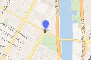
145th Street is a station on the IRT Lenox Avenue Line of the New York City Subway. Located at the intersection of 145th Street and Lenox Avenue in Harlem, Manhattan, it is served by the 3 train at all times. Built for the Interborough Rapid Transit Company (IRT), the 145th Street station contains two side platforms that can only fit six and a half train cars, unlike almost all other IRT stations, which are able to fit full-length ten-car trains.
145 Street | ||||||||||||||||||||||||||||||||||||||||||||||||||||||||||||||||||||||||||||||||||||||||||||||||
|---|---|---|---|---|---|---|---|---|---|---|---|---|---|---|---|---|---|---|---|---|---|---|---|---|---|---|---|---|---|---|---|---|---|---|---|---|---|---|---|---|---|---|---|---|---|---|---|---|---|---|---|---|---|---|---|---|---|---|---|---|---|---|---|---|---|---|---|---|---|---|---|---|---|---|---|---|---|---|---|---|---|---|---|---|---|---|---|---|---|---|---|---|---|---|---|---|
 Downtown platform | ||||||||||||||||||||||||||||||||||||||||||||||||||||||||||||||||||||||||||||||||||||||||||||||||
| Station statistics | ||||||||||||||||||||||||||||||||||||||||||||||||||||||||||||||||||||||||||||||||||||||||||||||||
| Address | West 145th Street & Malcolm X Boulevard New York, NY 10037[1] | |||||||||||||||||||||||||||||||||||||||||||||||||||||||||||||||||||||||||||||||||||||||||||||||
| Borough | Manhattan | |||||||||||||||||||||||||||||||||||||||||||||||||||||||||||||||||||||||||||||||||||||||||||||||
| Locale | Harlem | |||||||||||||||||||||||||||||||||||||||||||||||||||||||||||||||||||||||||||||||||||||||||||||||
| Coordinates | 40°49′14″N 73°56′10″W | |||||||||||||||||||||||||||||||||||||||||||||||||||||||||||||||||||||||||||||||||||||||||||||||
| Division | A (IRT) | |||||||||||||||||||||||||||||||||||||||||||||||||||||||||||||||||||||||||||||||||||||||||||||||
| Line | IRT Lenox Avenue Line | |||||||||||||||||||||||||||||||||||||||||||||||||||||||||||||||||||||||||||||||||||||||||||||||
| Services | 3 | |||||||||||||||||||||||||||||||||||||||||||||||||||||||||||||||||||||||||||||||||||||||||||||||
| Transit | ||||||||||||||||||||||||||||||||||||||||||||||||||||||||||||||||||||||||||||||||||||||||||||||||
| Structure | Underground | |||||||||||||||||||||||||||||||||||||||||||||||||||||||||||||||||||||||||||||||||||||||||||||||
| Platforms | 2 side platforms | |||||||||||||||||||||||||||||||||||||||||||||||||||||||||||||||||||||||||||||||||||||||||||||||
| Tracks | 2 | |||||||||||||||||||||||||||||||||||||||||||||||||||||||||||||||||||||||||||||||||||||||||||||||
| Other information | ||||||||||||||||||||||||||||||||||||||||||||||||||||||||||||||||||||||||||||||||||||||||||||||||
| Opened | November 23, 1904 | |||||||||||||||||||||||||||||||||||||||||||||||||||||||||||||||||||||||||||||||||||||||||||||||
| Closed | July 23, 2018 (reconstruction) | |||||||||||||||||||||||||||||||||||||||||||||||||||||||||||||||||||||||||||||||||||||||||||||||
| Rebuilt | November 28, 2018 | |||||||||||||||||||||||||||||||||||||||||||||||||||||||||||||||||||||||||||||||||||||||||||||||
| Station code | 437[3] | |||||||||||||||||||||||||||||||||||||||||||||||||||||||||||||||||||||||||||||||||||||||||||||||
| Opposite- direction transfer | No | |||||||||||||||||||||||||||||||||||||||||||||||||||||||||||||||||||||||||||||||||||||||||||||||
| Traffic | ||||||||||||||||||||||||||||||||||||||||||||||||||||||||||||||||||||||||||||||||||||||||||||||||
| 2019 | 954,825[4] | |||||||||||||||||||||||||||||||||||||||||||||||||||||||||||||||||||||||||||||||||||||||||||||||
| Rank | 368 out of 424[4] | |||||||||||||||||||||||||||||||||||||||||||||||||||||||||||||||||||||||||||||||||||||||||||||||
| Station succession | ||||||||||||||||||||||||||||||||||||||||||||||||||||||||||||||||||||||||||||||||||||||||||||||||
| Next north | Harlem–148th Street: 3 | |||||||||||||||||||||||||||||||||||||||||||||||||||||||||||||||||||||||||||||||||||||||||||||||
| Next south | 135th Street: 3 | |||||||||||||||||||||||||||||||||||||||||||||||||||||||||||||||||||||||||||||||||||||||||||||||
| ||||||||||||||||||||||||||||||||||||||||||||||||||||||||||||||||||||||||||||||||||||||||||||||||
| ||||||||||||||||||||||||||||||||||||||||||||||||||||||||||||||||||||||||||||||||||||||||||||||||
| ||||||||||||||||||||||||||||||||||||||||||||||||||||||||||||||||||||||||||||||||||||||||||||||||
| ||||||||||||||||||||||||||||||||||||||||||||||||||||||||||||||||||||||||||||||||||||||||||||||||
145th Street Subway Station (IRT) | ||||||||||||||||||||||||||||||||||||||||||||||||||||||||||||||||||||||||||||||||||||||||||||||||
| MPS | New York City Subway System MPS | |||||||||||||||||||||||||||||||||||||||||||||||||||||||||||||||||||||||||||||||||||||||||||||||
| NRHP reference No. | 05000231[5] | |||||||||||||||||||||||||||||||||||||||||||||||||||||||||||||||||||||||||||||||||||||||||||||||
| Added to NRHP | March 30, 2005 | |||||||||||||||||||||||||||||||||||||||||||||||||||||||||||||||||||||||||||||||||||||||||||||||
The station opened in 1904 as one of the northern termini of the original subway line operated by the IRT. With the construction of the Harlem–148th Street station to the north in the 1960s, the 145th Street station was planned to be closed, but due to community opposition, and passengers' protests, the station remained open. Since the 145th Street station is the second-to-last stop on the line, entry is provided only to the southbound platform, although northbound customers are allowed to exit from this station. The station was added to the National Register of Historic Places in 2005, and was closed from July to November 2018 for extensive renovations.
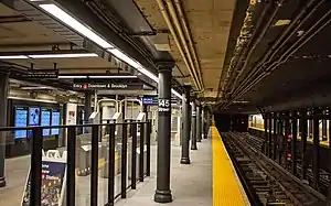
The 145th Street station contains two side platforms and two tracks. The station was built with tile and mosaic decorations. The platforms contain exits to Lenox Avenue's intersection with 145th Street and are not connected to each other within fare control.
History
Construction and opening

Planning for the city's first subway line dates to the Rapid Transit Act, authorized by the New York State Legislature in 1894.[6]:139–140 The subway plans were drawn up by a team of engineers led by William Barclay Parsons, chief engineer of the Rapid Transit Commission. It called for a subway line from New York City Hall in lower Manhattan to the Upper West Side, where two branches would lead north into the Bronx.[7]:3 A plan was formally adopted in 1897, and legal challenges were resolved near the end of 1899.[6]:148 The Rapid Transit Construction Company, organized by John B. McDonald and funded by August Belmont Jr., signed Contract 1 with the Rapid Transit Commission in February 1900,[8] in which it would construct the subway and maintain a 50-year operating lease from the opening of the line.[6]:182 In 1901, the firm of Heins & LaFarge was hired to design the underground stations.[7]:4 Belmont incorporated the Interborough Rapid Transit Company (IRT) in April 1902 to operate the subway.[6]:182
The 145th Street station was constructed as part of the IRT's East Side Branch (now the Lenox Avenue Line).[8][9]:253 The original plan envisioned a station on the Lenox Avenue Line at 141st Street, just south of the 142nd Street Junction, where a spur of the Lenox Avenue Line diverges to the Bronx via the IRT White Plains Road Line. This was ultimately not built, and instead, the 145th Street station became the last stop on the Lenox Avenue Line before it entered the Lenox Yard, a train maintenance yard immediately to the north.[5]:7 McMullan & McBean began work on the section from 135th Street and Lenox Avenue to Gerard Avenue and 149th Street, including the 145th Street spur, on September 10, 1901.[8][9]:253
On November 23, 1904, the East Side Branch opened to 145th Street.[10][11] Initially, the station was served by East Side local and express trains. Local trains ran from City Hall to Lenox Avenue (145th Street). Express trains had their southern terminus at South Ferry or Atlantic Avenue and had their northern terminus at 145th Street or West Farms (180th Street).[12] Express trains to 145th Street were eliminated in 1906.[13]
Later years
In 1918, the Broadway–Seventh Avenue Line opened south of Times Square–42nd Street, thereby dividing the original line into an "H" system. Local trains were sent to South Ferry.[14] The service at the station became the 3 (Lenox Avenue local) in 1948.[15] In 1959, all 3 trains became express.[16]
With the construction of the Harlem–148th Street station inside the Lenox Yard in the 1960s, the 145th Street station was planned to be closed, since the 148th Street station was intended as a direct replacement for the 145th Street station.[17] However, the proposal was shelved due to protests from the local community over the long walk of up to seven blocks to either the new station or 135th Street one stop south, and due to possible congestion issues at 135th Street.[17] The 148th Street station opened on May 13, 1968;[18] despite its name, the new terminal was located at 149th Street.[19]
From 1995 to 2008, this station lacked full-time service, as 3 trains did not operate during late nights. Full-time service was restored on July 27, 2008. During late nights, riders could take the M7, the M102, or a shuttle bus to 135th Street.[20][21] The station was added to the National Register of Historic Places on March 30, 2005, due to its importance as one of the first IRT stations to be built.[22]
Starting on March 2, 1998, the tunnel was reconstructed along with the cracked tunnel floor. This was done to correct a major water problem that had existed for many years due to the presence of the Harlem Creek and other underground streams, which caused extensive flooding, water damage, and seepage problems that occasionally contributed to severe service disruptions.[23][24] The project cost $82 million and was finished on October 12, 1998.[23][25] During the reconstruction, 3 trains were rerouted to the 137th Street–City College station on the IRT Broadway–Seventh Avenue Line. Supplemental shuttle bus service connecting to other lines in the area were provided for much of this time.[26][27]
Under the 2015–2019 Metropolitan Transportation Authority Capital Plan, the station underwent a complete overhaul as part of the Enhanced Station Initiative and was entirely closed for several months. Updates included cellular service, Wi-Fi, USB charging stations, interactive service advisories and maps.[28][29] In January 2018, the New York City Transit and Bus Committee recommended that Citnalta-Forte receives the $125 million contract for the renovations of 167th and 174th–175th Streets on the IND Concourse Line and 145th Street on the IRT Lenox Avenue Line.[30] However, the MTA Board temporarily deferred the vote for these packages after city representatives refused to vote to award the contracts.[31][32] The contract was put back for a vote in February, where it was ultimately approved.[33] The subway station was closed for renovations from July 23 to November 28, 2018.[34][35] Due to the closure, 2018 ridership dropped 41.9% compared to the previous year, from 1,093,045 riders in 2017 to 635,413 riders in 2018.[4]
Station layout
| G | Street level | Exit and southbound entrance |
| P Platform level |
Side platform | |
| Northbound | ← | |
| Southbound | | |
| Side platform | ||
There are two tracks with two short side platforms.[5]:5[36] The station is 348 feet (106 m) long and can fit six-and-a-half 51-foot (16 m) IRT subway cars.[5]:6 Only the first five cars of a train open here because the R62 subway cars used on the 3 service are configured in five-car sets and each must have their doors opened at the same time (selective door operation is used).[17] Before trains on the 3 service were lengthened from nine to ten cars in 2001, only four cars opened their doors at the station.[37] The station is slightly offset under Lenox Avenue, being located closer to the avenue's western curb line.[5]:16
Design
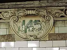
The fare control is at platform level, and there is no crossover or crossunder between the platforms. The station agent's booth is located on the southbound platform.[38] The station has mosaic name tablets, some old "145" terra cotta cartouches, and a mosaic replica of a cartouche.[5]:6[39][40][41] There were formerly women's and men's restrooms on the southbound platform, evidenced by stone lintels reading "women" and "men".[5]:7 The central section of the southbound platform widens near the turnstiles.[5]:7[42]
As with other stations built as part of the original IRT, the tunnel is covered by a "U"-shaped trough that contains utility pipes and wires. The bottom of this trough contains a foundation of concrete no less than 4 inches (100 mm) thick. The lowest sections of the trough's outer walls are composed of transverse arches 5 feet (1.5 m) wide.[5]:5 Each platform consists of 3-inch-thick (7.6 cm) concrete slabs, beneath which are located drainage basins. Columns between the tracks, placed atop the transverse arches, support the jack-arched concrete station roofs.[5]:5[7]:4 Unlike in most original IRT stations, the majority of these columns are not built-up I-beams.[5]:6 Along the northern end of the platforms there are dense clusters of I-beam columns,[43] while the remainder of the platform contains circular, cast-iron Doric-style columns spaced every 15 feet (4.6 m). The ceiling is about 15 feet (4.6 m) above platform level; the section of the ceiling north of the fare control area is smooth, and the section south of fare control is composed of segmental vaults supported by the center columns. There is a 1-inch (25 mm) gap between the trough wall and the platform walls, which are made of 4-inch (100 mm)-thick brick covered over by a tiled finish.[5]:6
The 2018 artwork at this station is Parade, a ceramic and glass artwork by Derek Fordjour. It consists of images depicting the African-American parade tradition of Harlem.[44]
Track layout
Like the other stations on the original IRT subway, it was initially built for trains shorter in length than the standard eight to ten cars used by the subway. In the 1950s and 1960s, all of the other IRT stations were either lengthened to 10 cars or closed.[45][46] The 145th Street station was also lengthened slightly to the north: there are no columns between the tracks there, since the site formerly accommodated a track crossover.[47] When 145th Street was planned to be closed in the 1960s, it was deemed unnecessary to further lengthen the platforms. Because it remained open, 145th Street is the only original IRT station besides the 42nd Street Shuttle stations that still cannot accommodate ten-car trains.[48] Approximately 200 feet (61 m) north of the station is a diamond crossover for the approach to the northern terminal of the 3 train at Harlem–148th Street. Approximately 300 feet (91 m) south of the station is the 142nd Street Junction with the IRT White Plains Road Line.[48] A track crossover formerly existed immediately south of the station, and another switch existed immediately north of the original platforms, within the space occupied by the current platform extension.[47]
Exits

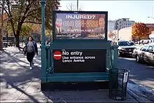
Street staircases from platform level go up to all four corners of 145th Street and Lenox Avenue. One street staircase goes to each of the corners; the stairs on the west side of Lenox Avenue serve the southbound platform, while the stairs on the east side are served by the northbound platform. There is no entrance from the street to the northbound platform, as both eastern street staircases contain a high exit-only turnstile and emergency gate.[5]:5[49][50] Like the other original IRT stations, this station originally was built with entrances resembling elaborate kiosks, which were removed for reducing sight lines for motorists.[51] The street staircases were replaced with relatively simple, modern steel railings like those seen at most New York City Subway stations.[5]:8
References
- "Borough of Manhattan, New York City". Government of New York City. Retrieved April 16, 2020.
- "Manhattan Bus Map" (PDF). Metropolitan Transportation Authority. July 2019. Retrieved December 1, 2020.
- "Station Developers' Information". Metropolitan Transportation Authority. Retrieved June 13, 2017.
- "Facts and Figures: Annual Subway Ridership 2014–2019". Metropolitan Transportation Authority. 2020. Retrieved May 26, 2020.
- "New York MPS 145th Street Subway Station (IRT)". Records of the National Park Service, 1785 - 2006, Series: National Register of Historic Places and National Historic Landmarks Program Records, 2013 - 2017, Box: National Register of Historic Places and National Historic Landmarks Program Records: New York, ID: 75313909. National Archives.
- Walker, James Blaine (1918). Fifty Years of Rapid Transit — 1864 to 1917. New York, N.Y.: Law Printing. Retrieved November 6, 2016.
- "Interborough Rapid Transit System, Underground Interior" (PDF). New York City Landmarks Preservation Commission. October 23, 1979. Retrieved November 19, 2019.
- Report of the Board of Rapid Transit Railroad Commissioners for the City of New York For The Year Ending December 31, 1904 Accompanied By Reports of the Chief Engineer and of the Auditor. Board of Rapid Transit Railroad Commissioners. 1905. pp. 229–236.
- Scott, Charles (1978). "Design and Construction of the IRT: Civil Engineering" (PDF). Historic American Engineering Record. pp. 208–282 (PDF pp. 209–283). Retrieved December 20, 2020.
 This article incorporates text from this source, which is in the public domain.
 - Report of the Public Service Commission For The First District of the State of New York For The Year Ending December 31, 1909. Albany: Public Service Commission. 1910. p. 191.
- "East Side Subway Open — Train from 145th Street to Broadway in 9 Minutes and 40 Seconds" (PDF). The New York Times. November 23, 1904. p. 1. ISSN 0362-4331. Retrieved March 27, 2016.
- The Merchants' Association of New York Pocket Guide to New York. Merchants' Association of New York. March 1906. pp. 19–26.
- Brooklyn Daily Eagle Almanac. Brooklyn Daily Eagle. 1916. p. 119.
- "Open New Subway Lines to Traffic; Called a Triumph — Great H System Put in Operation Marks an Era in Railroad Construction — No Hitch in the Plans — But Public Gropes Blindly to Find the Way in Maze of New Stations — Thousands Go Astray — Leaders in City's Life Hail Accomplishment of Great Task at Meeting at the Astor". The New York Times. August 2, 1918. p. 1. Retrieved November 6, 2016.
- "Open New Subway Lines to Traffic; Called a Triumph" (PDF). The New York Times. August 2, 1918. p. 1. ISSN 0362-4331. Retrieved October 4, 2011.
- "Wagner Praises Modernized IRT — Mayor and Transit Authority Are Hailed as West Side Changes Take Effect". The New York Times. February 7, 1959. p. 21. ISSN 0362-4331. Retrieved November 6, 2016.
- Edwards, Dick (December 2, 1967). "145th-Lenox Subway Stop To Continue". New York Amsterdam News. Archived from the original on July 10, 2015. Retrieved July 10, 2015.
- "IRT Passengers Get New 148th St. Station" (PDF). The New York Times. May 14, 1968. p. 95. Retrieved October 4, 2011.
- Raudenbush, Henry (January 2007). "148th Street-Lenox Terminal and How it Got its Name". New York Division Bulletin. Electric Railroaders Association. 50 (1). Retrieved June 20, 2016.
- "Service Enhancements on 3 Line" (Press release). MTA New York City Transit. July 24, 2008. Archived from the original on October 30, 2014. Retrieved December 23, 2014.
- Cox, Jeremiah (June 24, 2008). "A close up of the sign saying late nights no 3 service at 145 Street and to use the shuttle bus (that appears on Manhattan bus maps) or M7 or 102 to 135 Street for 2 service". subwaynut.com. Retrieved November 28, 2018.
- "Notice: National Register of Historic Places; pending nominations". Federal Register. Department of the Interior: National Park Service. 70 (46): 12009. March 10, 2005. 05-4640. Retrieved March 28, 2020 – via National Archives.
- "New York City Transit - History and Chronology". mta.info. Metropolitan Transportation Authority. Archived from the original on March 24, 2020. Retrieved April 8, 2020.
- Lii, Jane H. (February 28, 1998). "Tunnel Work To Cut Service On 2 Subways". The New York Times. p. B-4. ISSN 0362-4331. Archived from the original on March 28, 2020. Retrieved January 17, 2020.
- Lueck, Thomas J. (October 13, 1998). "Beating Deadline, Normal Service Returns for the Nos. 2 and 3 Subway Lines". The New York Times. p. B-3. ISSN 0362-4331. Archived from the original on March 28, 2020. Retrieved January 17, 2020.
- Newman, Andy (December 12, 1997). "Repairs to Lenox Ave. Tunnel To Affect Many Subway Lines". The New York Times. p. B-8. Archived from the original on March 28, 2020. Retrieved July 31, 2013.
- "Lenox Rehab '98 2 3 Lenox Line Service Guide March 2-October 1998". thejoekorner.com. New York City Transit. 1998. Archived from the original on March 28, 2020. Retrieved November 6, 2016.
- Whitford, Emma (January 8, 2016). "MTA Will Completely Close 30 Subway Stations For Months-Long "Revamp"". Gothamist. Archived from the original on March 23, 2020. Retrieved July 18, 2016.
- "MTA Stations" (PDF). governor.ny.gov. Government of the State of New York. Archived (PDF) from the original on November 2, 2019. Retrieved July 18, 2016.
- Transit & Bus Committee Meeting (PDF). New York City Transit and Bus Committee Meeting. Metropolitan Transportation Authority. January 22, 2018. p. 135. Archived (PDF) from the original on April 29, 2020. Retrieved January 19, 2018.
- Barone, Vincent (January 24, 2018). "Subway station upgrades in Manhattan, Bronx on hold after MTA board tables vote". am New York. Archived from the original on October 3, 2019. Retrieved January 25, 2018.
- Siff, Andrew (January 24, 2018). "MTA Shelves Plan to Modernize Subway Stations Amid Criticism". NBC New York. Archived from the original on April 29, 2020. Retrieved January 25, 2018.
- "Foes Hit Gov's Station Fix Plan". NY Daily News. February 13, 2018. Retrieved February 23, 2018.
- "Subway Stations in Harlem and the Bronx to Receive Structural Repairs and Improvements This Summer" (Press release). Metropolitan Transportation Authority. July 3, 2018. Archived from the original on April 29, 2020. Retrieved July 6, 2018.
- "Planned Service Changes for: Wednesday, November 28, 2018". Metropolitan Transportation Authority. November 28, 2018. Archived from the original on November 29, 2018. Retrieved February 12, 2019.
- Dougherty, Peter (2006) [2002]. Tracks of the New York City Subway 2006 (3rd ed.). Dougherty. OCLC 49777633 – via Google Books.
- "April 1997 New York City Subway Map" (PDF). mta.nyc.ny.us. New York City Transit Authority. April 1997. Archived from the original (PDF) on July 4, 1997. Retrieved November 28, 2018.
- Cox, Jeremiah (June 24, 2008). "The entrance area outside of fare control at 145 Street". subwaynut.com. Retrieved November 28, 2018.
- Cox, Jeremiah (June 24, 2008). "A mosaic name tablet at 145 Street". subwaynut.com. Retrieved November 28, 2018.
- Cox, Jeremiah (June 24, 2008). "A flat mosaic replica of a terra cotta cartouche at 145 Street". subwaynut.com. Retrieved November 28, 2018.
- Cox, Jeremiah (June 24, 2008). "A close up of a terra cotta cartouche at 145 Street it is identical with other then the numbers in it to similar cartouches at all the other Lenox Avenue stations except 110 Street". subwaynut.com. Retrieved November 28, 2018.
- Chatreau, Bernard (September 23, 2011). "Showing Image 144186". www.nycsubway.org. Retrieved November 28, 2018.
- Weinberg, Brian (May 17, 2004). "Showing Image 30454". www.nycsubway.org. Retrieved November 28, 2018.
- "145th Street - Derek Fordjour - Parade, 2018". web.mta.info. Metropolitan Transportation Authority. Archived from the original on April 30, 2020. Retrieved April 30, 2020.
- Report for the three and one-half years ending June 30, 1949. New York City Board of Transportation. 1949. hdl:2027/mdp.39015023094926.
- "More Long Platforms – Five Subway Stations on IRT to Accommodate 10-Car Trains" (PDF). The New York Times. July 10, 1948. p. 8. ISSN 0362-4331. Retrieved March 27, 2016.
- Lynch, Andrew (2020). "New York City Subway Track Map" (PDF). vanshnookenraggen.com. Retrieved February 6, 2020.
- Dougherty, Peter (2020). Tracks of the New York City Subway 2020 (16th ed.). Dougherty. OCLC 1056711733.
- "MTA Neighborhood Maps: Harlem / Hamilton Heights" (PDF). mta.info. Metropolitan Transportation Authority. 2018. Retrieved October 1, 2018.
- Cox, Jeremiah (June 24, 2008). "A no entry exit from the uptown platform at 145 Street viewed from Lenox Avenue". subwaynut.com. Retrieved November 28, 2018.
- Pirmann, David. "Former IRT Kiosk". www.nycsubway.org. Retrieved November 28, 2018.
External links
| Wikimedia Commons has media related to 145th Street (IRT Lenox Avenue Line). |
- nycsubway.org – IRT White Plains Road Line: 145th Street
- Station Reporter — 3 Train
- The Subway Nut — 145th Street Pictures Archived September 22, 2009, at the Wayback Machine
- 145th Street entrance from Google Maps Street View
- Platforms from Google Maps Street View


