A23 autoroute
The A23 autoroute is a highway in northern France. It is 42.5 kilometres (26.4 mi) long.
_Route_marker.gif)
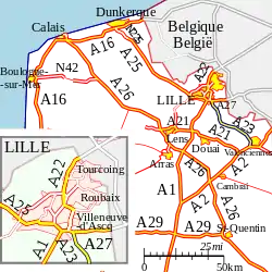
The A23 in northern France
Route
The road passes northwest/southeast from the Lille conurbation to the town of Valenciennes effectively linking the A1 and A2 autoroutes.
Junctions
| Exit/Junction | Destination |
| Exchange A23/A27 Starts at junction with | |
| (Lesquin) 2km Towns served: Lesquin | |
| (Orchies) 16km Towns served: Orchies, Douai, Tournai (Belgium) | |
| (Orchies) 16km Towns served: Coutiches | |
| (Orchies) 16km Towns served: Coutiches | |
| (Marciennes) 26km Towns served: St-Amand-les-Eaux | |
| (Hasnon) 32km Towns served: St-Amand-les-Eaux, Wallers | |
| (St Amand les Eaux) 35km Towns served: St-Amand-les-Eaux, Tournai (Belgium) | |
| (Raismes) 36km Towns served: St-Amand-les-Eaux, Tournai (Belgium) | |
| (Petit-Forêt) 39km Towns served: Raismes, Anzin | |
| (Valenciennes-Nord) 43km Towns Served: Valenciennes | |
| (Paris-Denain/Valenciennes-Ouest) 43km Towns Served: Valenciennes | |
| Exchange A23/A2: | |
References
External links
 |
| | |
This article is issued from Wikipedia. The text is licensed under Creative Commons - Attribution - Sharealike. Additional terms may apply for the media files.