Acadia National Park carriage paths, bridges and gatehouses
Acadia National Park, on Mount Desert Island, off the coast of the U.S. state of Maine, was created in part by land and other donations by John D. Rockefeller Jr. Between 1919 and 1931, Rockefeller, who was opposed to the introduction of automobiles on the island, personally oversaw the construction of a network of carriage roads, closed to motorized vehicles, on the eastern half of the island, including sixteen granite bridges and two gatehouses. The major portion of this network now falls within the bounds of the national park, and was listed on the National Register of Historic Places in 1979.
Carriage Paths, Bridges and Gatehouses | |
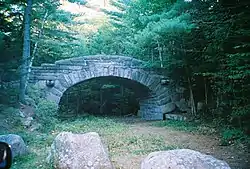
 Stone bridge at Bubble Pond, September 2005 | |
 | |
| Nearest city | Bar Harbor, Maine |
|---|---|
| Coordinates | 44°21′N 68°13′W |
| Built | 1919 |
| Architect | Grosvenor Atterbury |
| Architectural style | Tudor Revival |
| NRHP reference No. | 79000131[1] |
| Added to NRHP | November 14, 1979 |
The network of carriage roads is open to the public for non-motorized uses in the summer, including walking and bicycling.[2] In the winter, most of the network is open to cross-country skiing, and a portion of it is open to snowmobiling.
History
Beginning in about 1890, Mount Desert Island became a summer resort haven for a number of wealthy families, including the Rockefellers, Carnegies, and Vanderbilts. Despite their efforts to keep the island free of motor vehicles, their presence was authorized across the whole island by 1915. John D. Rockefeller, Jr., who had a large summer house on the southeastern part of the island, in response embarked on a major to build a network of carriage roads on its eastern half, which would be isolated from the roads open to motor vehicles, and which would provide access to the scenic views of the area. He personally selected the skilled craftsmen who built the roads, bridges, and gatehouses, and directly supervised a significant portion of the work, which took place between 1919 and 1931. The overall design was approved by Frederick Law Olmsted, Jr. The entire project resulted in the construction of more than 50 miles (80 km) of roads, sixteen bridges, and two Tudor Revival gatehouses at the points where the system intersected the public roads. The present bounds of Acadia National Park include 47 miles (76 km) of these roads, thirteen of its bridges, and both gatehouses.[3]
Description
Carriage paths and bridges

.jpg.webp)
.jpg.webp)
The carriage paths consist of a network of wide paths, laid out to take advantage of the area's natural terrain, and to provide access to fine views of the area's lakes, mountains, and bays. Foot paths extend from the carriage paths into the woods. The carriage paths are about 16 feet (4.9 m) wide, and are generally surfaced by the National Park Service with fine gravel, with a slight rise at the center to allow for proper drainage.[3]
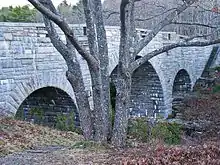
The bridges in the network are all built out of hand-hewn locally quarried granite. They were specifically designed to blend into the landscape in an organic manner, and are sited so that they may be used as viewing platforms for the scenery, and so that they may themselves be viewed. They often include viewing platforms for one or both purposes. The only bridge that has been altered in any significant way is the Eagle Lake Bridge, which carries Maine State Route 233 over a carriage path, and was the subject of an award-winning widening project in 1974.[3]
Gatehouses
The Brown Mountain Gatehouse, also known locally as "The Lodge", is near the southwestern corner of the park on Maine State Routes 3 and 198. It is a small complex consisting of the gatehouse, a caretaker's house, and carriage house, and was designed in the Tudor Revival style by Grosvenor Atterbury. It is built of rubble-stone masonry, with occasional bands of precisely-laid dressed stone and brick. The buildings are roofed in polychrome terra cotta tile. The gates are made of cypress wood, and are set in a segmented-arch opening. This lodge, like the one at Jordan Pond, is now used for park service staff housing. On the inside of the gate, away from the main road, there is an expansive area of landscaped lawn.[3]
The Jordan Pond Gatehouse is at the southern end of Jordan Pond, where the carriage path network intersects the main park loop road. Like the Brown Mountain Gatehouse, it was also designed by Atterbury and contains similar elements and styling. It is laid out in a more linear fashion, with its elements joined by a masonry fence. The towers that flank the gates are topped by bellcast roofs with terra cotta tile.[3]
See also
References
- "National Register Information System". National Register of Historic Places. National Park Service. January 23, 2007.
- https://bicyclenewengland.com/2018/04/01/bicycling-acadia-park-maine/
- "NRHP nomination for Carriage Paths, Bridges, and Gatehouses". National Park Service. Retrieved 2015-01-17.
External links
| Wikimedia Commons has media related to Carriage Paths, Bridges and Gatehouses. |
- Historic American Engineering Record documentation, all filed under Hancock County, ME:
- HAER No. ME-13, "Rockefeller Carriage Roads, Mount Desert Island, Bar Harbor", 20 photos, 7 color transparencies, 4 measured drawings, 139 data pages, 3 photo caption pages
- HAER No. ME-31, "Cobblestone Bridge, Spanning Jordan Stream on Gardiner–Mitchell Hill–Jordan Stream Carriage Road, Seal Harbor", 4 photos, 6 data pages, 1 photo caption page
- HAER No. ME-32, "Little Harbor Brook Bridge, Spanning Little Harbor Brook on Asticou–Jordan Pond Carriage Road", 2 photos, 7 data pages, 1 photo caption page
- HAER No. ME-33, "Jordan Pond Dam Bridge, Spanning Jordan Stream on Jordan Pond Carriage Road, Seal Harbor", 2 photos, 6 data pages, 1 photo caption page
- HAER No. ME-34, "Hemlock Bridge, Spanning Maple Spring Brook on West Sargent Mountain Carriage Road, Northeast Harbor", 7 photos, 2 color transparencies, 10 data pages, 1 photo caption page
- HAER No. ME-35, "Waterfall Bridge, Spanning Upper Hadlock Brook on West Sargent Mountain Carriage Road, Northeast Harbor", 9 data pages
- HAER No. ME-36, "Deer Brook Bridge, Spanning Deer Brook on Eagle Lake–Jordan Pond Carriage Road, Seal Harbor", 3 photos, 7 data pages, 1 photo caption page
- HAER No. ME-37, "Hadlock Brook Bridge, Spanning Hadlock Brook on Upper Hadlock Brook Carriage Road, Northeast Harbor", 6 data pages
- HAER No. ME-38, "Chasm Brook Bridge, Spanning Chasm Brook on West Sargent Mountain Carriage Road, Bar Harbor", 3 photos, 6 data pages, 1 photo caption page
- HAER No. ME-39, "Bubble Pond Bridge, Spanning abandoned Motor Road on Bubble Pond Carriage Road, Bar Harbor", 2 photos, 1 measured drawing, 16 data pages, 1 photo caption page
- HAER No. ME-40, "Duck Brook Bridge, Spanning Duck Brook between Witch Hole Loop and New Eagle Lake Road, Bar Harbor", 6 photos, 8 data pages, 1 photo caption page
- HAER No. ME-41, "Amphitheater Bridge, Spanning Little Harbor Brook on Amphitheater Carriage Road, Seal Harbor", 8 photos, 10 data pages, 1 photo caption page
- HAER No. ME-42, "West Branch Jordan Stream Bridge, Spanning West Branch Jordan Stream on Amphitheater Carriage Road, Seal Harbor", 4 photos, 6 data pages, 1 photo caption page
- HAER No. ME-43, "Cliffside Bridge, Spanning Jordan Ravine on Amphitheatre Carriage Road, Seal Harbor", 10 photos, 9 data pages, 1 photo caption page
- HAER No. ME-44, "Jordan Pond Road Bridge, Spanning Barr Hill–Day Mountain Carriage Road on Jordan Pond Road, Seal Harbor", 2 photos, 11 data pages, 1 photo caption page
- HAER No. ME-45, "Stanley Brook Bridge, Spanning Stanley Brook, Stanley Brook Motor Road, and Seaside Trail on Barr Hill–Day Mountain Carriage Road", 5 photos, 1 measured drawing, 9 data pages, 1 photo caption page
- HAER No. ME-46, "Triad–Day Mountain Bridge, Spanning Park Loop Road at Triad–Day Mountain Pass, Seal Harbor", 4 photos, 7 data pages, 1 photo caption page
- HAER No. ME-49, "Eagle Lake Little Bridges, Spanning Duck Brook and Breakneck Brook on Eagle Lake Carriage Road, Bar Harbor", 2 photos, 4 data pages, 1 photo caption page
- HAER No. ME-50, "Aunt Betty's Pond Road Little Bridges, Spanning unidentified stream on Aunt Betty's Pond Carriage Road, Bar Harbor", 3 photos, 4 data pages, 1 photo caption page
- HAER No. ME-53, "Brown Mountain Gate Lodge, Maine Route 3, 1/2 mile north of Asticou, Northeast Harbor", 5 photos, 2 measured drawings, 1 photo caption page
- HAER No. ME-54, "Jordan Pond Gate Lodge, Park Loop Road, 1 mile north of Seal Harbor, Seal Harbor", 4 photos, 2 measured drawings, 1 photo caption page
- HAER No. ME-55, "Eagle Lake Bridge, Spanning Carriage Road on Eagle Lake Road (Route 233), Bar Harbor", 4 photos, 11 data pages, 1 photo caption page