Aguinaldo Highway
The Emilio Aguinaldo Highway,[1] (often shortened as Aguinaldo Highway), formerly referred to as Cavite–Batangas Road and Manila West Road, is a four-to-six lane, 41.4-kilometer (25.7 mi), network of primary and secondary highways passing through the busiest towns and cities of Cavite, Philippines.[2][3][4][5] It is the busiest and most congested of the three major highways located in the province, the others are Juanito Remulla Sr. Road (Governor's Drive) and Antero Soriano Highway.
.svg.png.webp) .svg.png.webp) .svg.png.webp) R-2  | |
|---|---|
| Cavite–Batangas Road Manila West Road Silang Diversion Road | |
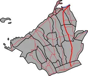 Aguinaldo Highway highlighted in red | |
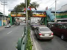
.jpg.webp) Aguinaldo Highway looking south towards Tagaytay Rotonda in Tagaytay | |
| Route information | |
| Maintained by the Department of Public Works and Highways | |
| Length | 41.4 km (25.7 mi) |
| Component highways | |
| Major junctions | |
| North end | |
| |
| South end | |
| Location | |
| Provinces | Metro Manila, Cavite |
| Major cities | Las Piñas, Bacoor, Imus, Dasmariñas, Tagaytay |
| Towns | Silang |
| Highway system | |
| |
The highway is named in the honor of General Emilio Aguinaldo, the country's first president.
.svg.png.webp)
The northern terminus of the highway is located at Las Piñas in Metro Manila. It then travels along Bacoor, Imus, Dasmariñas, Silang, and then ends at Tagaytay in Cavite. The highway forms part of National Routes 62, 419, and 410 of the Philippine highway network. The highway has several official names, like Manila–Cavite Road and Cavite–Batangas Road. The west alignment of the poblacion area of Silang, is unnumbered as a newer bypass named Silang Bypass Road (or Silang Diversion Road), designated as a tertiary road. The section that connects with Manila–Cavite Expressway (then Coastal Road), called the Aguinaldo Boulevard is also designated as National Route 62 (N62) of the Philippine highway network.
Route description

Aguinaldo Highway passes through many establishments such as malls, shops, and government offices. Various high voltage power lines, most notably the Dasmariñas-Las Piñas transmission line of National Grid Corporation of the Philippines (NGCP), utilize the highway right of way from its intersection with Aguinaldo Boulevard and Bacoor Boulevard to Barangay San Agustin 2, Dasmariñas for accessibility to work vehicles and also due to scarcity of land for dedicated right of way.
Originally a four-lane, it starts as a continuation of Diego Cera Avenue at Zapote Bridge. It crosses and becomes a six-lane road past Bacoor Boulevard which leads to Molino, Bacoor, and Aguinaldo Boulevard, which connects with Manila–Cavite Expressway. It then intersects with Tirona Highway that leads to Kawit and Cavite City. It then passes Imus and enters Dasmarinas, where it reduces to a four-lane road and becoming a divided highway in most portions. Afterwards, it then intersects with Juanito Remulla Sr. Road (Governor's Drive) at Pala-Pala, Dasmariñas.
Past Pala-Pala, it begins its climb to Tagaytay, passing Silang, and then ends in Tagaytay rotunda. The highway continues as Tagaytay–Nasugbu Highway as it passes the rest Tagaytay and Alfonso in Cavite before entering the province of Batangas.
History
The present road originated from an old road that enters Cavite from Las Piñas. The old roads that predated the Aguinaldo Highway used a different alignment on Bacoor and Imus, that exist until today as a mixture of city-maintained roads and national roads. Portions of the road have been sites of battles of the Philippine Revolution.
During the American colonial era, the road reached as far as Silang, until an extension to Tagaytay was opened. The old roads that passed on the western barangays of Bacoor and Imus are bypassed by a new alignment that existed until today. The road was designated Highway 17 and named Manila West Road, that reached as far as the municipality of Batangas (present-day Batangas City).
Intersections
Intersections are numbered by kilometer posts, with Rizal Park in Manila designated as kilometer zero.
| Region | Province | City/Municipality | km[6] | mi | Destinations | Notes | ||
|---|---|---|---|---|---|---|---|---|
| Metro Manila | Las Piñas | 14.793 | 9.192 | Northern terminus. Continues north as | ||||
| Metro Manila–Calabarzon boundary | Las Piñas–Cavite boundary | Las Piñas–Bacoor boundary | 14.846 | 9.225 | Zapote Bridge over Zapote River Las Piñas-Muntinlupa District Engineering Office–Cavite Sub District Engineering Office highway boundary | |||
| Calabarzon | Cavite | Bacoor | A. Evangelista Street / Molino Road | |||||
| Traffic light intersection | ||||||||
| 17.456 | 10.847 | Traffic light intersection. Route number change from N62 to N419. | ||||||
| Bacoor–Imus boundary | 18.943 | 11.771 | Cavite Sub District Engineering Office–Cavite 1st District Engineering Office highway boundary | |||||
| Imus | 20.050 | 12.458 | Imus Bridge over Imus River | |||||
| Buhay na Tubig Road | Traffic light intersection | |||||||
| Palico Daanan Road | ||||||||
| Nueno Avenue | ||||||||
| Patindig Araw Road | ||||||||
| Daang Hari / Open Canal Road | At-grade interchange; traffic light intersection | |||||||
| Imus–Dasmariñas boundary | 26.998 | 16.776 | Cavite 1st District Engineering Office–Cavite Sub District Engineering Office highway boundary | |||||
| Dasmariñas | Salitran Road | |||||||
| Congressional Road | Traffic light intersection. Serves De La Salle University - Dasmariñas Campus. | |||||||
| Don Placido Campos Avenue | ||||||||
| Ramon Tirona Avenue | ||||||||
| Traffic light intersection | ||||||||
| Traffic light intersection | ||||||||
| Dasmariñas–Silang boundary | 38.985 | 24.224 | Route number change from N419 to N410 | |||||
| Silang | Cavite–Laguna Expressway | Future Silang West Interchange under construction | ||||||
| Change from N410 to unnumbered route | ||||||||
| Silang–Banaybanay Road | Traffic light intersection | |||||||
| Changed from unnumbered route to N410 | ||||||||
| Buho–Amadeo Road | ||||||||
| Silang–Tagaytay boundary | 53.763 | 33.407 | Cavite Sub District Engineering Office–Cavite 2nd District Engineering Office highway boundary | |||||
| Tagaytay | 56.894 | 35.352 | Roundabout. Southern Terminus. | |||||
1.000 mi = 1.609 km; 1.000 km = 0.621 mi
| ||||||||
References
- "Emilio Aguinaldo Highway". bacoor.gov.ph. Retrieved August 21, 2018.
- "Las Piñas-Munti". www.dpwh.gov.ph. Archived from the original on January 9, 2018. Retrieved January 9, 2018.
- "Cavite Sub". www.dpwh.gov.ph. Archived from the original on January 9, 2018. Retrieved January 9, 2018.
- "Cavite 2nd". www.dpwh.gov.ph. Archived from the original on January 8, 2018. Retrieved January 9, 2018.
- "Cavite". www.dpwh.gov.ph. Archived from the original on January 9, 2018. Retrieved January 9, 2018.
- "Road and Bridge Inventory". www.dpwh.gov.ph. Retrieved 2018-01-20.
External links
| Wikimedia Commons has media related to Aguinaldo Highway. |
| Expressways |
| ||||||||
|---|---|---|---|---|---|---|---|---|---|
| National roads |
| ||||||||
| Arterial Routes |
| ||||||||