Buli, Muntinlupa
Buli is a barangay in Muntinlupa, Philippines. The total land area of Buli is 0.437 km2, the smallest in the city. It has a population of 7,319 making it the least populated barangay in Muntinlupa. It is located in the northern section of the city.
Buli | |
|---|---|
| Country | |
| Region | Metro Manila |
| City | Muntinlupa |
| Congressional district | Legislative district of Muntinlupa |
| Area | |
| • Total | 0.437 km2 (0.169 sq mi) |
| Population (2010 Census[1]) | |
| • Total | 7,319 |
| • Density | 17,000/km2 (43,000/sq mi) |
| ZIP code | 1771 |
| Dialing Code | +63 (0)02 |

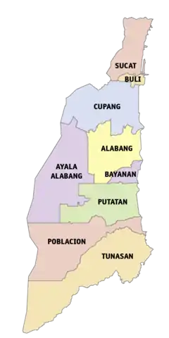
Political map of Muntinlupa
Buli is located south of the Manila. It is bounded on the north by the Muntinlupa Barangay of Sucat, on the south by the Muntinlupa barangay of Cupang, and on the east by the Laguna de Bay.
History
Buli is said to be named after the buri palm that is abundant in the area.
See also
References
- "Population Counts - National Capital Region" (PDF). 2010 Census and Housing Population. National Statistics Office. Retrieved 2015-08-21.
External links
This article is issued from Wikipedia. The text is licensed under Creative Commons - Attribution - Sharealike. Additional terms may apply for the media files.