Cementon, Pennsylvania
Cementon is an unincorporated area and census-designated place (CDP) in Lehigh County, Pennsylvania, United States. The town is in Whitehall Township, 7 miles (11 km) north of Allentown. As of the 2010 census, the population of Cementon was 1,538.[2] It uses the Whitehall ZIP code of 18052.
Cementon, Pennsylvania | |
|---|---|
.jpg.webp) | |
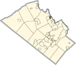 Location in Lehigh County | |
 Cementon Location in Pennsylvania  Cementon Location in the United States | |
| Coordinates: 40°41′21″N 75°30′27″W | |
| Country | United States |
| State | Pennsylvania |
| County | Lehigh |
| Township | Whitehall |
| Area | |
| • Total | 0.67 sq mi (1.74 km2) |
| • Land | 0.65 sq mi (1.69 km2) |
| • Water | 0.02 sq mi (0.05 km2) |
| Elevation | 315 ft (96 m) |
| Population | |
| • Total | 1,538 |
| • Density | 2,364/sq mi (912.7/km2) |
| Time zone | UTC-5 (Eastern (EST)) |
| • Summer (DST) | UTC-4 (EDT) |
| ZIP code | 18052 |
| Area code(s) | 610 & 484 |
| FIPS code | 42-11976 |
| GNIS feature ID | 1171410 |
Geography
Cementon is in northeastern Lehigh County, situated along the Lehigh River, across from the borough of Northampton in Northampton County. It is bordered to the west by the unincorporated community of Egypt. Pennsylvania Route 329 passes through the center of Cementon, crossing the Lehigh east into Northampton and leading west through Egypt to Neffs. Pennsylvania Route 145 forms the western boundary of Cementon, crossing PA 329 in the Eagle Point neighborhood. PA 145 leads northwest 8 miles (13 km) to Walnutport and south to the center of Allentown.
According to the U.S. Census Bureau, the Cementon CDP has a total area of 0.66 square miles (1.7 km2), of which 0.02 square miles (0.05 km2), or 2.94%, are water.[1] Via the Lehigh River, the town is part of the Delaware River watershed.
History
| Historical population | |||
|---|---|---|---|
| Census | Pop. | %± | |
| 2000 | 1,319 | — | |
| 2010 | 1,538 | 16.6% | |
Cementon was originally known as "Siegfried's Ferry", as it is located directly across the Lehigh River from Siegfried (one of the three villages that would merge to become Northampton in 1902). In 1828, a bridge was built across the river, and the town became known as Siegfried's Bridge. After a large Whitehall Portland Cement Works quarry and mill were established in 1900/01, the town was renamed "Cementon".[3]
Education
Cementon is part of the Whitehall-Coplay School District. Students in grades nine through 12 attend Whitehall High School.
References
| Wikimedia Commons has media related to Cementon, Pennsylvania. |
- Roberts, Charles Rhoads; Rev. John Baer Stoudt; Rev. Thomas H. Krick; William J. Dietrich (1914). History of Lehigh County Pennsylvania and Genealogical and Biographical Records of its Families. 1. Lehigh Valley Publishing Company.
- Roberts, Charles R. (1936). "Place Names of Lehigh County and Their Origin". Proceedings: Lehigh County Historical Society. Allentown, Pennsylvania: Lehigh County Historical Society.
Notes
- "2019 U.S. Gazetteer Files: Places: Pennsylvania". United States Census Bureau. Retrieved October 23, 2020.
- "Total Population: 2010 Census DEC Summary File 1 (P1), Cementon CDP, Pennsylvania". data.census.gov. U.S. Census Bureau. Retrieved October 23, 2020.
- Roberts 1936, p. 11
Places adjacent to Cementon, Pennsylvania | |
|---|---|
Municipalities and communities of Lehigh County, Pennsylvania, United States | ||
|---|---|---|
| Cities | 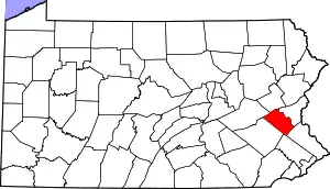 | |
| Boroughs | ||
| Townships | ||
| CDPs | ||
| Unincorporated communities |
| |
| Footnotes | ‡This populated place also has portions in an adjacent county or counties | |
| ||