French Equatorial Africa
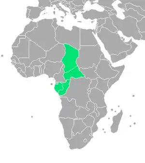
French Equatorial Africa (French: Afrique-Équatoriale française), or the AEF, was the federation of French colonial possessions in Equatorial Africa, extending northwards from the Congo River into the Sahel, and comprising what are today the countries of Chad, the Central African Republic, the Republic of the Congo, and Gabon.
French Equatorial Africa Afrique-Équatoriale française | |||||||||||||||||||
|---|---|---|---|---|---|---|---|---|---|---|---|---|---|---|---|---|---|---|---|
| 1910–1958 | |||||||||||||||||||
.svg.png.webp) Flag
 Coat of arms
| |||||||||||||||||||
 | |||||||||||||||||||
| Status | Federation of French colonies (1910–1934) French colony (1934–1958)[1] | ||||||||||||||||||
| Capital | Brazzaville | ||||||||||||||||||
| Official languages | French | ||||||||||||||||||
| Religion | Catholicism and others[2] | ||||||||||||||||||
| Governor-General | |||||||||||||||||||
• 1908–17 | Martial Henri Merlin | ||||||||||||||||||
• 1951–57 | Paul Louis Gabriel Chauvet | ||||||||||||||||||
| High-Commissioner | |||||||||||||||||||
• 1957–58 | Paul Louis Gabriel Chauvet | ||||||||||||||||||
• 1958 | Pierre Messmer | ||||||||||||||||||
| History | |||||||||||||||||||
• Established | 15 January 1910 | ||||||||||||||||||
• Disestablished | September 1958 | ||||||||||||||||||
| Currency | French Equatorial African franc CFA franc | ||||||||||||||||||
| |||||||||||||||||||
| Today part of | |||||||||||||||||||
History
Established in 1910, the Federation contained four (later five) colonial possessions: French Gabon, French Congo, Ubangi-Shari and French Chad. The Governor-General was based in Brazzaville with deputies in each territory.
In 1911, France ceded parts of the territory to German Kamerun as a result of the Agadir Crisis. The territory was returned after Germany's defeat in World War I, while most of Cameroon proper became a French League of Nations mandate not integrated into the AEF.
During the late 1920s and early 1930s an anti-colonial movement Société Amicale des Originaires de l'A.E.F. was established by André Matsoua,[3] seeking French citizenship for the territory's inhabitants.[4]
During World War II, the federation rallied to the Free French Forces under Félix Éboué in August 1940, except for Gabon which was Vichy French until 12 November 1940, when the Vichy administration surrendered to invading Free French; the federation became the strategic centre of Free French activities in Africa.
Under the Fourth Republic (1946–58), the federation was represented in the French parliament. When the territories voted in the September 1958 referendum to become autonomous within the French Community, the federation was dissolved. In 1959 the new republics formed an interim association called the Union of Central African Republics, before becoming fully independent in August 1960.
Administration
Until 1934, French Equatorial Africa was a federation of French colonies like French West Africa. That year, however, the AEF became a unitary entity and its constituent colonies became known as regions, later becoming known as territories in 1937.[5] There was a single budget for the unified colony; prior to unification, each member had had its own finances.[6]
As of 1942, the AEF was administered by a governor-general, who had "the supreme direction of all services, both civil and military."[7] However, his power was limited in practice by France's centralising colonial policy. "Most important legislation is enacted in Paris," wrote the authors of the 1942 British naval intelligence handbook for the colony, "whilst the governor-general fills in minor details and penalties."[7] The governor-general was assisted by a consultative council of administration (Conseil d'Administration) composed of important local officials and some members, both African and European, elected indirectly.[7]
Under the unified colony, three of the constituent territories were administered by a governor, while Moyen-Congo was under the purview of the governor-general. Each had a council of local interests (Conseil des Interêts Locaux) similar to the council of administration. Locally, the territories were subdivided into départments and subdivisions overseen by appointed officials.[8] The only municipalities were the capitals of the territories, which were classified as communes mixtes as opposed to Senegal's communes de plein exercise which had democratically elected councils. Although these municipalities possessed certain powers of local self-government, their mayors and councils---which included African representatives---were appointed.[9]
Postage stamps

The postal administrations of the four territories were separate until 1936, each issuing its own stamps. In that year, stamps of Gabon and Middle Congo were overprinted AFRIQUE / ÉQUATORIALE / FRANÇAISE. A definitive series for the colony followed in 1937, featuring local scenes and key French figures in the formation of the colony, with various color and value changes each year through 1940.
The 1937 series was overprinted AFRIQUE FRANÇAISE / LIBRE or just LIBRE in 1940 by the Free French, and in 1941 they issued a series depicting a phoenix rising from the flames.
A new definitive series, featuring local scenery and people, was issued in 1946, and another twenty-odd stamps came out during the 1950s, with the last being the omnibus Human Rights issue on 10 December 1958.[10]
See also
References
- Naval Intelligence Division (1942), French Equatorial Africa and Cameroons, 258.
- Abidogun, Jamaine M. (2 June 2020). The Palgrave Handbook of African Education and Indigenous Knowledge. p. 193. ISBN 9783030382773.
- Ansprenger, Franz (1989). The Dissolution of the Colonial Empires. London: Routledge. p. 103. ISBN 9780415031431.
- Bazenguissa-Ganga, Rémy (1997). Les voies du politique au Congo: essai de sociologie historique (in French). Paris: Karthala. p. 29. ISBN 9782865377398.
- Naval Intelligence Division, 258-260.
- Naval Intelligence Division, 445.
- Naval Intelligence Division, 258.
- Naval Intelligence Division, 258-261.
- Naval Intelligence Division, 261.
- Retrieved 12 August 2018.
Bibliography
- Pakenham, Thomas (1991). The Scramble for Africa, 1876–1912. London: Weidenfeld and Nicolson. ISBN 0-297-81130-4.
- Naval Intelligence Division (1942). French Equatorial African and Cameroons. London, UK.
- Petringa, Maria (2006). Brazza, a Life for Africa. Bloomington, IN: AuthorHouse. ISBN 978-1-4259-1198-0.
- Shillington, Kevin, ed. (2005). "Colonial Federations: French Equatorial Africa". Encyclopedia of African History. Fitzroy Dearborn. pp. 260–261. ISBN 978-1-135-45670-2.
- "France: Africa: French Equatorial Africa (French Congo)". Statesman's Year-Book. London: Macmillan and Co. 1921. pp. 886–888 – via Internet Archive.
External links
| Wikimedia Commons has media related to French Equatorial Africa. |
