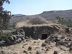
Ghuwayr Abu Shusha
Ghuwayr Abu Shusha was a Palestinian Arab village in the Tiberias Subdistrict. It was depopulated during the 1947–1948 Civil War in Mandatory Palestine on April 21, 1948. It was located 8 km north of Tiberias, nearby Wadi Rubadiyya.
Ghuwayr Abu Shusha
غُويّر أبو شوشة | |
|---|---|
 Maqam Sheikh Abu Shusha | |
| Etymology: from personal name; meaning the “father of” wearing “a top knot”[1] | |
.jpg.webp) 1870s map 1870s map .jpg.webp) 1940s map 1940s map.jpg.webp) modern map modern map .jpg.webp) 1940s with modern overlay map 1940s with modern overlay mapA series of historical maps of the area around Ghuwayr Abu Shusha (click the buttons) | |
 Ghuwayr Abu Shusha Location within Mandatory Palestine | |
| Coordinates: 32°51′13″N 35°30′26″E | |
| Palestine grid | 197/251 |
| Geopolitical entity | Mandatory Palestine |
| Subdistrict | Tiberias |
| Date of depopulation | 21 and 28 April 1948[2] |
| Area | |
| • Total | 8,609 dunams (8.609 km2 or 3.324 sq mi) |
| Population (1945) | |
| • Total | 1,240[4][3] |
| Cause(s) of depopulation | Military assault by Yishuv forces |
| Secondary cause | Influence of nearby town's fall |
| Current Localities | Ginosar,[5] Livnim[5] |
History
In 1838 Edward Robinson found on the remains of a few dwellings, built of rough volcanic stones, some of which were still used as magazines by the Arabs of the plain. A wely with a white dome marked the spot. He found no traces of antiquity.[6]
In 1850-1851 de Saulcy saw the village, which he described as ruined. Of the village, all which remained was a few portions of wall of modern appearance, "but in the midst of these is still standing a square vaulted tower, constructed in fine blocks of Herodian workmanship, or Roman of the early empire. This tower rests against a wall of more recent character."[7]
In 1875 Victor Guérin visited and noted the little wely dedicated to Abou-Choutheh.[8]
In 1881, the PEF's Survey of Western Palestine (SWP) described it as containing 20 Moslems, with housed built of basalt, located round a mill.[9] There were modern ruins in the village, and a number of ruined mills in the valley below.[10]
British mandate era
In the 1945 statistics it had a population of 1,240 Muslims,[4] with 8,609 dunams of land.[3] Of this, 21 dunams were used for citrus and bananas, 1,377 for plantations and irrigable land, 1,848 dunams for cereals,[11] while 6 dunams were classified as built-up (urban) area.[12]
Ruins of watermills could be seen at the nearby Khirbat Abu Shusha.[13]
1948, and aftermath
The village was depopulated after a military assault on 21 and 28 April 1948.[2]
Ginosar presently occupy part of what was village land, so does Livnim, established in 1982 ca. 1 km northwest of the Ghuwayr Abu Shusha site.[5]
In 1992 the village site was described: "The village site is covered with thorns and wild vegetation, including Christ's-thorn trees and cactuses. The shrine of Shaykh Muhammad and the remains of a mill can be seen among piles of stones and a few olive trees. The lower-lying lands are planted in bananas and citrus, while the highlands are used as grazing areas by the Israelis."[5]
Gallery
 Maqam sheikh Abu Shusha, 2015
 Maqam sheikh Abu Shusha, 2015
 Maqam sheikh Abu Shusha, 2015
References
- Palmer, 1881, p. 128
- Morris, 2004, p. xvii, village #93. Also gives cause of depopulation.
- Government of Palestine, Department of Statistics. Village Statistics, April, 1945. Quoted in Hadawi, 1970, p. 72
- Department of Statistics, 1945, p. 12
- Khalidi, 1992, p. 517
- Robinson and Smith, 1841, vol 3, pp. 285-286; cited in Khalidi, 1992, p. 516
- Saucy, 1854, pp. 423-424
- Guérin, 1880, pp. 209-212
- Conder and Kitchener, 1881, SWP I, p. 360
- Conder and Kitchener, 1881, SWP I, p. 396
- Government of Palestine, Department of Statistics. Village Statistics, April, 1945. Quoted in Hadawi, 1970, p. 122
- Government of Palestine, Department of Statistics. Village Statistics, April, 1945. Quoted in Hadawi, 1970, p. 172
- Khalidi, 1992, p. 516
Bibliography
- Conder, C.R.; Kitchener, H.H. (1881). The Survey of Western Palestine: Memoirs of the Topography, Orography, Hydrography, and Archaeology. 1. London: Committee of the Palestine Exploration Fund.
- Department of Statistics (1945). Village Statistics, April, 1945. Government of Palestine.
- Guérin, V. (1880). Description Géographique Historique et Archéologique de la Palestine (in French). 3: Galilee, pt. 1. Paris: L'Imprimerie Nationale.
- Hadawi, S. (1970). Village Statistics of 1945: A Classification of Land and Area ownership in Palestine. Palestine Liberation Organization Research Center.
- Khalidi, W. (1992). All That Remains: The Palestinian Villages Occupied and Depopulated by Israel in 1948. Washington D.C.: Institute for Palestine Studies. ISBN 0-88728-224-5.
- Morris, B. (2004). The Birth of the Palestinian Refugee Problem Revisited. Cambridge University Press. ISBN 978-0-521-00967-6.
- Palmer, E.H. (1881). The Survey of Western Palestine: Arabic and English Name Lists Collected During the Survey by Lieutenants Conder and Kitchener, R. E. Transliterated and Explained by E.H. Palmer. Committee of the Palestine Exploration Fund.
- Robinson, E.; Smith, E. (1841). Biblical Researches in Palestine, Mount Sinai and Arabia Petraea: A Journal of Travels in the year 1838. 3. Boston: Crocker & Brewster.
- Saulcy, L.F. de (1854). Narrative of a journey round the Dead Sea, and in the Bible lands, in 1850 and 1851. 2, new edition. London: R. Bentley.
External links
- Welcome To Ghuwayr Abu Shusha
- Ghuwayr Abu Shusha, Zochrot
- Survey of Western Palestine, Map 6: IAA, Wikimedia commons