Grade II* listed buildings in Bournemouth
There are over 20,000 Grade II* listed buildings in England. This page is a list of these buildings in the district of Bournemouth in Dorset.
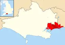
Bournemouth shown in Dorset
List of buildings
| Name | Location | Type | Completed [note 1] | Date designated | Grid ref.[note 2] Geo-coordinates |
Entry number [note 3] | Image |
|---|---|---|---|---|---|---|---|
| Bournemouth War Memorial with associated steps, enclosure and balustrade | Bournemouth | War memorial | 1922 | 12 March 2014 | SZ0843191322 50°43′17″N 1°52′55″W |
1418017 |  Bournemouth War Memorial with associated steps, enclosure and balustrade |
| Church of St Alban | Bournemouth | Church | 1907–09 | 27 February 1976 | SZ0966793231 50°44′19″N 1°51′52″W |
1152784 |  Church of St Alban |
| Church of St Ambrose | Bournemouth | Church | 1898–1900 | 27 February 1976 | SZ0714090871 50°43′03″N 1°54′01″W |
1108803 |  Church of St Ambrose |
| Church of St Andrew | Kinson | Church | 13th century | 5 May 1972 | SZ0679596925 50°46′19″N 1°54′18″W |
1324727 | |
| Church of St John the Evangelist | Boscombe | Church | 1893–95 | 27 February 1976 | SZ1105591713 50°43′30″N 1°50′41″W |
1152799 |  Church of St John the Evangelist |
| Church of St Michael (including tower) | Bournemouth | Church | 1873–76 | 5 May 1952 | SZ0794391197 50°43′13″N 1°53′20″W |
1324732 |  Church of St Michael (including tower) |
| House of Bethany | Bournemouth | House | 1880 | 27 February 1976 | SZ1085692112 50°43′43″N 1°50′51″W |
1108819 |  House of Bethany |
| Roman Catholic Church of the Annunciation | Bournemouth | Church | 1905–06 | 27 February 1976 | SZ0972493181 50°44′17″N 1°51′49″W |
1110033 | 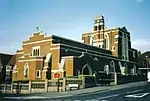 Roman Catholic Church of the Annunciation |
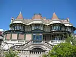
| Russell-Cotes Art Gallery & Museum | Bournemouth | House | 1894 | 1 August 1974 | SZ0922290894 50°43′03″N 1°52′15″W |
1108857 |

Notes
- The date given is the date used by Historic England as significant for the initial building or that of an important part in the structure's description.
- Sometimes known as OSGB36, the grid reference is based on the British national grid reference system used by the Ordnance Survey.
- The "List Entry Number" is a unique number assigned to each listed building and scheduled monument by Historic England.
External links
This article is issued from Wikipedia. The text is licensed under Creative Commons - Attribution - Sharealike. Additional terms may apply for the media files.