Grade II* listed buildings in Bolsover (district)
There are over 20,000 Grade II* listed buildings in England. This page is a list of these buildings in the district of Bolsover in Derbyshire.
| Name | Location | Type | Completed [note 1] | Date designated | Grid ref.[note 2] Geo-coordinates |
Entry number [note 3] | Image |
|---|---|---|---|---|---|---|---|
| Range of outbuildings and stables, and walls enclosing a courtyard to south of Hardwick Hall | Hardwick Park, Ault Hucknall | Stables | 17th century | 8 July 1966 | SK4636263478 53°09′59″N 1°18′29″W |
1051634 | 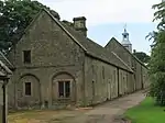 Range of outbuildings and stables, and walls enclosing a courtyard to south of Hardwick Hall |
| Barlborough Old Hall | Barlborough | Manor house | 17th century | 26 August 1965 | SK4764577296 53°17′26″N 1°17′12″W |
1335416 |  |
| Beightonfields Priory | Barlborough | Country house | 17th century | 26 August 1965 | SK4559276749 53°17′09″N 1°19′03″W |
1052227 | 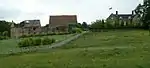 Beightonfields Priory |
| Church of St James | Barlborough | Church | 12th century | 26 August 1965 | SK4769677188 53°17′22″N 1°17′09″W |
1335412 | 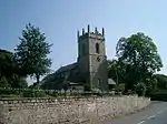 Church of St James |
| Gazebo at Barlborough Hall | Barlborough | Gazebo | 17th century | 23 March 1989 | SK4765278265 53°17′57″N 1°17′11″W |
1367143 | 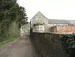 Gazebo at Barlborough Hall |
| Village Cross | Barlborough | Cross | 14th century | 26 August 1965 | SK4761677277 53°17′25″N 1°17′14″W |
1039862 | 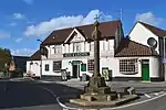 Village Cross |
| Newton Old Hall | Blackwell | House | Mid 17th century | 11 July 1951 | SK4438459217 53°07′42″N 1°20′17″W |
1367111 |  Newton Old Hall |
| Church of St John the Baptist | Clowne | Church | 12th century | 26 August 1965 | SK4982875294 53°16′20″N 1°15′15″W |
1040039 | |
| Clowne Cross | Clowne | Market cross | 14th century | 26 August 1965 | SK4914875437 53°16′25″N 1°15′52″W |
1108957 | 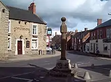 Clowne Cross |
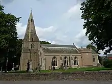
| Church of St Peter | Elmton | Church | 20th century | 26 August 1965 | SK5026573452 53°15′21″N 1°14′53″W |
1335410 | 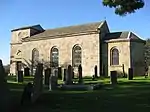 Church of St Peter |
| Church of the Holy Cross | Langwith | Church | 13th century | 8 July 1966 | SK5187869331 53°13′07″N 1°13′28″W |
1335434 | 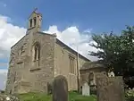 Church of the Holy Cross |
| Church of St Mary and St Laurence | Old Bolsover | Church | 13th century | 5 July 1965 | SK4744270306 53°13′40″N 1°17′27″W |
1054045 | |
| Conduit house | Old Bolsover | Conduit house | 17th century | 5 July 1965 | SK4755969987 53°13′29″N 1°17′21″W |
1108954 | |
| Conduit house | Old Bolsover | Conduit house | 17th century | 5 July 1965 | SK4716270440 53°13′44″N 1°17′42″W |
1054750 | |
| Conduit house to rear of Number 85 | Old Bolsover | Conduit house | 17th century | 5 July 1965 | SK4745670116 53°13′34″N 1°17′26″W |
1372046 | |
| Conduit house to south-east of St Bernadette's Church | Old Bolsover | Conduit House | 17th century | 5 July 1965 | SK4733970250 53°13′38″N 1°17′32″W |
1108981 | 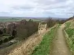 Conduit house to south-east of St Bernadette's Church |
| The Cundy House | Old Bolsover | Conduit house | 17th century | 23 March 1989 | SK4712370917 53°14′00″N 1°17′44″W |
1367442 |  The Cundy House |
| Church of St Michael | Pleasley | Church | 12th century | 8 July 1966 | SK5042864572 53°10′33″N 1°14′49″W |
1108926 | 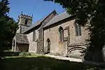 Church of St Michael |
| Church of St Leonard | Scarcliffe | Church | 12th century | 8 July 1966 | SK4954368750 53°12′49″N 1°15′34″W |
1054908 | |
| Carnfield Hall | South Normanton | House | Early 17th century | 11 July 1951 | SK4257056044 53°06′00″N 1°21′56″W |
1367071 | |
| Church of St Michael | South Normanton | Church | 13th century | 8 July 1966 | SK4422256961 53°06′29″N 1°20′27″W |
1108933 | 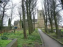 Church of St Michael |
| Park Hall | Spinkhill | Country house | 17th century | 26 August 1965 | SK4626478794 53°18′15″N 1°18′26″W |
1372089 | 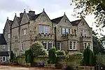 Park Hall |
| Whitwell Hall | Whitwell | Manor house | 17th century | 19 November 1951 | SK5260976914 53°17′12″N 1°12′44″W |
1055849 | |


See also
- Grade I listed buildings in Derbyshire
- Grade II* listed buildings in Amber Valley
- Grade II* listed buildings in Chesterfield
- Grade II* listed buildings in Derby
- Grade II* listed buildings in Derbyshire Dales
- Grade II* listed buildings in Erewash
- Grade II* listed buildings in High Peak
- Grade II* listed buildings in North East Derbyshire
- Grade II* listed buildings in South Derbyshire
Notes
- The date given is the date used by Historic England as significant for the initial building or that of an important part in the structure's description.
- Sometimes known as OSGB36, the grid reference is based on the British national grid reference system used by the Ordnance Survey.
- The "List Entry Number" is a unique number assigned to each listed building and scheduled monument by Historic England.
External links
![]() Media related to Grade II* listed buildings in Derbyshire at Wikimedia Commons
Media related to Grade II* listed buildings in Derbyshire at Wikimedia Commons
This article is issued from Wikipedia. The text is licensed under Creative Commons - Attribution - Sharealike. Additional terms may apply for the media files.