Grade II* listed buildings in Runnymede (district)
There are over 20,000 Grade II* listed buildings in England. This page is a list of the twenty Grade II* buildings in the district of Runnymede in Surrey. For links to similar articles in relation to the other 10 districts of Surrey see Grade II* listed buildings in Surrey.
| Name | Location | Type | Completed [note 1] | Date designated | Grid ref.[note 2] Geo-coordinates |
Entry number [note 3] | Image |
|---|---|---|---|---|---|---|---|
| Botleys Park Mansion | Chertsey, Runnymede | Great House | Modern | 9 June 1972 | TQ0214264884 51°22′26″N 0°32′02″W |
1029181 | |
| Cemex House (formerly formerly RMC House) | Egham, Runnymede | House | 1988–1989 | 10 July 2014 | TQ0297668821 51°24′33″N 0°31′15″W |
1420102 |  |
| Church of Saint John the Baptist | Egham, Runnymede | Church | 1817-1820 | 11 July 1951 | TQ0130871367 51°25′56″N 0°32′39″W |
1189321 | |
| Lychgate of the Church of Saint John the Baptist | Egham, Runnymede | Lych Gate | 1744 | 11 July 1951 | TQ0127771405 51°25′57″N 0°32′40″W |
1028978 | |
| Church of Saint Simon and Saint Jude | Englefield Green, Runnymede | Church | 1859 | 17 November 1986 | SU9928270838 51°25′40″N 0°34′24″W |
1028958 |  Church of Saint Simon and Saint Jude |
| Pair of Mausolea | Englefield Green, Runnymede | Chest Tomb | Dated 1862 | 17 August 1989 | SU9931170807 51°25′39″N 0°34′23″W |
1242772 |  Pair of Mausolea |
| Church of St Mary | Thorpe, Runnymede | Church | 12th century | 17 November 1986 | TQ0238468642 51°24′27″N 0°31′46″W |
1189962 | 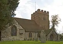 Church of St Mary |
| Church of St Peter | Chertsey, Runnymede | Parish Church | 13th century | 26 September 1951 | TQ0420266995 51°23′33″N 0°30′13″W |
1029167 | 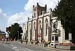 Church of St Peter |
| Curfew House | Chertsey, Runnymede | House | 18th century | 26 September 1951 | TQ0414567018 51°23′34″N 0°30′16″W |
1242226 | |
| Englefield Green House | Englefield Green, Runnymede | House | 18th century or earlier | 17 November 1986 | SU9927371689 51°26′08″N 0°34′24″W |
1378020 | |
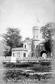
| Fort Belvedere | Egham, Runnymede | Country house | c. 1828 | 17 November 1986 | SU9663668184 51°24′16″N 0°36′44″W |
1294245 | |
| Pyrcroft House | Chertsey, Runnymede | House | Mid 18th century | 26 September 1951 | TQ0334666818 51°23′28″N 0°30′58″W |
1377926 |  Pyrcroft House |
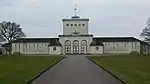
| Royal Air Force Memorial | Runnymede | War Memorial | 1953 | 25 September 1998 | SU9983771942 51°26′16″N 0°33′54″W |
1376599 | |
| St Ann's Court | Chertsey, Runnymede | Villa | 1936-37 | 15 January 1986 | TQ0279067333 51°23′45″N 0°31′26″W |
1260122 |  St Ann's Court |
| Teahouse and Grotto in Grounds of St Ann's Hill House | Chertsey, Runnymede | Grotto | 18th century | 9 June 1972 | TQ0246667117 51°23′38″N 0°31′43″W |
1029160 | |
| The chapel at former Holloway Sanatorium | Virginia Water, Runnymede | Chapel | 1882-1884 | 17 November 1986 | TQ0026068257 51°24′16″N 0°33′36″W |
1119659 |  The chapel at former Holloway Sanatorium |
| The Cottage | Thorpe, Runnymede | House | 18th century | 11 July 1951 | TQ0215468789 51°24′32″N 0°31′57″W |
1378051 | |
| The Temple of Augustus (Leptis Magna) | Virginia Water, Runnymede | Wall | Roman | 17 November 1986 | SU9746568622 51°24′30″N 0°36′00″W |
1378028 | _(geograph_3935706).jpg.webp) The Temple of Augustus (Leptis Magna) |
| Thorpe House | Thorpe, Runnymede | House | 17th century | 11 July 1951 | TQ0231168781 51°24′32″N 0°31′49″W |
1190067 | |
| 25 Windsor Street | Chertsey, Runnymede | House | Early 18th century | 26 September 1951 | TQ0411867004 51°23′33″N 0°30′18″W |
1377931 | |


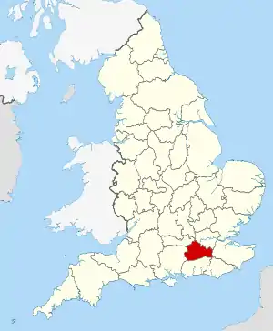
Surrey shown within England
Notes
- The date given is the date used by Historic England as significant for the initial building or that of an important part in the structure's description.
- Sometimes known as OSGB36, the grid reference is based on the British national grid reference system used by the Ordnance Survey.
- The "List Entry Number" is a unique number assigned to each listed building and scheduled monument by Historic England.
References
External links
![]() Media related to Grade II* listed buildings in Surrey at Wikimedia Commons
Media related to Grade II* listed buildings in Surrey at Wikimedia Commons
This article is issued from Wikipedia. The text is licensed under Creative Commons - Attribution - Sharealike. Additional terms may apply for the media files.