Grade II* listed buildings in South Gloucestershire
There are over 20,000 Grade II* listed buildings in England. This page is a list of these buildings in the district of South Gloucestershire in Gloucestershire.
South Gloucestershire
| Name | Location | Type | Completed [note 1] | Date designated | Grid ref.[note 2] Geo-coordinates |
Entry number [note 3] | Image |
|---|---|---|---|---|---|---|---|
| Parish Church of St Mary | Acton Turville, South Gloucestershire | Parish Church | 12th century | 3 March 1961 | ST8084480865 51°31′35″N 2°16′39″W |
1155143 | _Church_of_St_Mary_-_geograph.org.uk_-_67854.jpg.webp) Parish Church of St Mary |
| Archway to over Court | Over, Almondsbury, South Gloucestershire | Gate Lodge | Mid 18th century | 5 December 1984 | ST5869182309 51°32′17″N 2°35′49″W |
1321097 |  |
| Bishop's Farmhouse | Compton Greenfield, Almondsbury, South Gloucestershire | Farmhouse | Late 16th century | 5 December 1984 | ST5688781862 51°32′02″N 2°37′23″W |
1128857 | |
| Church of All Saints | Compton Greenfield, Almondsbury, South Gloucestershire | Parish Church | c. 1170 | 30 March 1960 | ST5708682226 51°32′14″N 2°37′12″W |
1321095 |  Church of All Saints |
| The Manor House | Gaunt's Earthcott, Almondsbury, South Gloucestershire | Farmhouse | 16th century | 21 October 1952 | ST6351284200 51°33′20″N 2°31′40″W |
1128866 | |
| Church of St John | Aust, South Gloucestershire | Parish Church | 15th century | 5 December 1984 | ST5724389081 51°35′56″N 2°37′07″W |
1136359 | 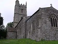 Church of St John |
| Church of St John | Elberton, Aust, South Gloucestershire | Parish Church | 14th century | 30 March 1960 | ST6023488188 51°35′28″N 2°34′32″W |
1136391 | 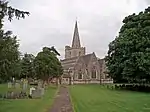 Church of St John |
| Church of St Mary of Malmesbury | Littleton-upon-Severn, Aust, South Gloucestershire | Parish Church | 14th century | 30 March 1960 | ST6006890226 51°36′34″N 2°34′41″W |
1312787 | _Church_-_geograph.org.uk_-_67878.jpg.webp) Church of St Mary of Malmesbury |
| Corston Farmhouse | Littleton Upon Severn, Aust, South Gloucestershire | Farmhouse | Early 17th century | 21 October 1952 | ST5985290244 51°36′35″N 2°34′52″W |
1136474 | |
| Badminton House Servants Wing, adjoining and immediately to the South West of Badminton House | Badminton Park, Badminton, South Gloucestershire | Servants' Wing | 1841 | 10 November 1983 | ST8060182858 51°32′39″N 2°16′52″W |
1129318 | |
| Castle Barn, flanking Dovecotes and Screen Walls | The Tyning, Badminton, South Gloucestershire | House | C20 | 10 November 1983 | ST7928482702 51°32′34″N 2°18′00″W |
1129344 | .jpg.webp) Castle Barn, flanking Dovecotes and Screen Walls |
| Essex House, and front Boundary Walls and Gate Piers | Badminton, South Gloucestershire | House | c. 1700 | 17 September 1952 | ST8047782683 51°32′34″N 2°16′58″W |
1155409 | 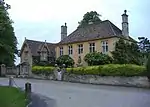 Essex House, and front Boundary Walls and Gate Piers |
| Hermit's Cell the Root House | Badminton Park, Badminton, South Gloucestershire | Root House | c. 1750 | 10 November 1983 | ST8113483850 51°33′12″N 2°16′25″W |
1320851 | 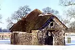 Hermit's Cell the Root House |
| Laundry and Dairy House 30 Yards to West of Badminton House | Badminton Park, Badminton, South Gloucestershire | House | 1983 | 10 November 1983 | ST8058882945 51°32′42″N 2°16′53″W |
1129315 | |
| Lower Slait Lodge | Badminton Park, Badminton, South Gloucestershire | Lodge | c. 1750 | 17 September 1952 | ST7982083828 51°33′11″N 2°17′33″W |
1129323 | .jpg.webp) Lower Slait Lodge |
| Orangery, 50 Yards to South East of Church of St Michael and All Angels | Badminton Park, Badminton, South Gloucestershire | Orangery | 1711 | 17 September 1952 | ST8070682807 51°32′38″N 2°16′47″W |
1129313 | |
| Pair of Cottages 20m to the West of Almshouses, Boundary Walls to Road and Gate Piers | Badminton, South Gloucestershire | Estate Cottage | Early 18th century | 3 March 1961 | ST8039682672 51°32′33″N 2°17′03″W |
1129329 | |
| Park Keepers House and Workshop Wing to East | Badminton Park, Badminton, South Gloucestershire | Estate Cottage | c. 1750 | 10 November 1983 | ST8042583945 51°33′15″N 2°17′01″W |
1155297 | .JPG.webp) Park Keepers House and Workshop Wing to East |
| Pond Cottage, 30m to South West of Badminton House | Badminton Park, Badminton, South Gloucestershire | House | 1983 | 10 November 1983 | ST8057182893 51°32′41″N 2°16′54″W |
1129316 | |
| Single Storey Ranges, Barn and Covered Way enclosing Four Sides of Courtyard at Stable Court to Badminton House | Badminton Park, Badminton, South Gloucestershire | Gate | 1878 | 10 November 1983 | ST8050682835 51°32′39″N 2°16′57″W |
1320860 | |
| The Almshouse and former School and Boundary Walls and Gate Piers to the Road | Badminton, South Gloucestershire | Almshouses | c1707-09 | 3 March 1961 | ST8043382678 51°32′34″N 2°17′01″W |
1129328 | .JPG.webp) The Almshouse and former School and Boundary Walls and Gate Piers to the Road |
| The Thatched Cottage | Badminton, South Gloucestershire | Cottage Ornee | c. 1750 | 10 November 1983 | ST8042082320 51°32′22″N 2°17′01″W |
1129341 | .JPG.webp) The Thatched Cottage |
| Two Houses immediately to the West of the Almshouses and Boundary Walls to Road | Badminton, South Gloucestershire | Estate Cottage | Early 18th century | 3 March 1961 | ST8040782674 51°32′33″N 2°17′02″W |
1155417 | |
| Church Farmhouse | Bitton, South Gloucestershire | Farmhouse | Mid 19th century | 15 July 1981 | ST6817069411 51°25′22″N 2°27′33″W |
1319783 | |
| Londonderry Farmhouse | Bitton, South Gloucestershire | Farmhouse | 1672 | 11 May 1953 | ST6637469878 51°25′37″N 2°29′06″W |
1116793 | |
| The Grange, Gates and Gate Piers at the South East Corner of the Grange | Bitton, South Gloucestershire | House | 17th century | 11 May 1953 | ST6818769312 51°25′19″N 2°27′32″W |
1116812 | |
| Hamswell House | Hamswell, Cold Ashton, South Gloucestershire | Farmhouse | 17th century | 17 September 1952 | ST7319271498 51°26′31″N 2°23′14″W |
1220723 |  Hamswell House |
| Church of St Peter | Wapley, Dodington, South Gloucestershire | Parish Church | 13th century | 15 August 1985 | ST7138079725 51°30′57″N 2°24′50″W |
1211521 | 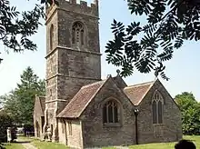 Church of St Peter |
| Codrington Court | Codrington, Dodington, South Gloucestershire | Farmhouse | 16th century | 17 September 1952 | ST7277778536 51°30′18″N 2°23′37″W |
1220995 | |
| The Cascade Building about 80m North East of Dodington House and Railings | Dodington Park, Dodington, South Gloucestershire | Gate | 1764 | 17 September 1952 | ST7531779939 51°31′04″N 2°21′26″W |
1211179 | |
| Church of Holy Trinity | Doynton, South Gloucestershire | Parish Church | 12th century | 15 August 1985 | ST7205574113 51°27′55″N 2°24′13″W |
1211665 | 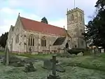 Church of Holy Trinity |
| Statue of Neptune About 320m East of Dyrham House | Dyrham Park, Dyrham and Hinton, South Gloucestershire | Statue | between 1700 and 1712 | 17 September 1952 | ST7444075665 51°28′46″N 2°22′10″W |
1212355 | 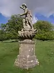 Statue of Neptune About 320m East of Dyrham House |
| Church of St Peter | Frampton Cotterell, South Gloucestershire | Anglican Church | 1858 | 25 September 1985 | ST6675882002 51°32′09″N 2°28′50″W |
1136248 | 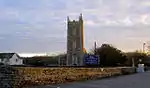 Church of St Peter |
| Blocks 1 and 2 and linking Arcade to Hanham Hall Hospital | Hanham Abbots, South Gloucestershire | House | 1655 | 15 July 1981 | ST6444071634 51°26′33″N 2°30′47″W |
1278348 | |
| Hanham Court | Hanham Green, Hanham Abbots, South Gloucestershire | House | Late Victorian-Early C20 | 11 May 1953 | ST6493870267 51°25′49″N 2°30′21″W |
1319770 | 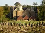 Hanham Court |
| Parish Church of St George | Hanham Green, Hanham Abbots, South Gloucestershire | Church | Earlier | 11 May 1953 | ST6496870274 51°25′49″N 2°30′19″W |
1116822 | |
| Tithe Barn to North of Hanham Court | Hanham Green, Hanham Abbots, South Gloucestershire | Tithe Barn | probably 15th century | 11 May 1953 | ST6494670306 51°25′50″N 2°30′20″W |
1116823 | |
| Coach House, Stables and Pigsty 40m to North of Swangrove House | Swangrove, Hawkesbury, South Gloucestershire | Garage | 1983 | 17 September 1952 | ST7967985847 51°34′16″N 2°17′41″W |
1129381 | |
| Dovecote | Little Badminton Green, Hawkesbury, South Gloucestershire | Dovecote | late medieval | 17 September 1952 | ST8009884108 51°33′20″N 2°17′18″W |
1303080 | .JPG.webp) Dovecote |
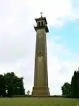
| Monument to Lord Robert Edward Somerset | Hawkesbury Upton, Hawkesbury, South Gloucestershire | Tower | 1846 | 10 November 1983 | ST7722787649 51°35′14″N 2°19′48″W |
1320834 | |
| Ragged Castle or Keeper's Lodge | Hawkesbury, South Gloucestershire | Garden Building | c. 1750 | 10 November 1983 | ST8050086093 51°34′24″N 2°16′58″W |
1156209 | |
| Church of St Michael | Hill, South Gloucestershire | Parish Church | 13th century | 30 March 1960 | ST6494295232 51°39′17″N 2°30′29″W |
1136564 |  Church of St Michael |
| Mudgedown Farmhouse | Iron Acton, South Gloucestershire | Farmhouse | Mid 17th century | 17 September 1952 | ST6840585060 51°33′49″N 2°27′26″W |
1116018 | |
| Rodway Hill Manor (East and West Wing) | Mangotsfield Rural, South Gloucestershire | House | Later | 11 May 1953 | ST6634675828 51°28′49″N 2°29′10″W |
1116174 | |
| Barn, 25m to North of Home Farmhouse | Marshfield, South Gloucestershire | Barn | 17th century OR EARLY 18th century | 17 September 1952 | ST7816273765 51°27′45″N 2°18′57″W |
1320825 | |
| Crispe Almshouses and Chapel | Marshfield, South Gloucestershire | Almshouse | 1612-1619 | 17 September 1952 | ST7739073771 51°27′45″N 2°19′37″W |
1302631 | 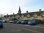 Crispe Almshouses and Chapel |
| Walls and Archway to the front of the Almshouses | Marshfield, South Gloucestershire | Wall and Gate | 1612-1619 | 10 November 1983 | ST7738973762 51°27′45″N 2°19′37″W |
1320796 | Walls and Archway to the front of the Almshouses |
| Dovecote, 5m to North-west of the Old Manor House | Marshfield, South Gloucestershire | Dovecote | C16/C17 | 17 September 1952 | ST7815273737 51°27′44″N 2°18′57″W |
1156549 | |
| Marshfield House | Marshfield, South Gloucestershire | House | Late 17th century | 17 September 1952 | ST7809273635 51°27′41″N 2°19′00″W |
1302595 | .jpg.webp) Marshfield House |
| The Catherine Wheel | Marshfield, South Gloucestershire | Public House | 1680/1690 | 17 September 1952 | ST7794273713 51°27′43″N 2°19′08″W |
1114934 | 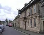 The Catherine Wheel |
| The Manor | Marshfield, South Gloucestershire | House | 17th century | 17 September 1952 | ST7819773717 51°27′43″N 2°18′55″W |
1302923 | |
| The Old Meeting House | Marshfield, South Gloucestershire | Unitarian Chapel | 1752 | 17 September 1952 | ST7777273700 51°27′43″N 2°19′17″W |
1157006 | |
| 123, High Street | Marshfield, South Gloucestershire | House | Early 18th century | 17 September 1952 | ST7757973726 51°27′43″N 2°19′27″W |
1114944 | |
| 14, High Street | Marshfield, South Gloucestershire | House | Mid 18th century | 17 September 1952 | ST7804473735 51°27′44″N 2°19′03″W |
1129418 | |
| Church of St Arilda | Oldbury-on-Severn, South Gloucestershire | Parish Church | 15th century | 30 March 1960 | ST6083891904 51°37′28″N 2°34′02″W |
1128916 |  Church of St Arilda |
| Fewster's Farmhouse | Kington, Oldbury-upon-Severn, South Gloucestershire | Farmhouse | 15th century | 21 September 1952 | ST6201190345 51°36′38″N 2°33′00″W |
1128813 | |
| Church of St Mary | Olveston, South Gloucestershire | Parish Church | late Norman | 30 March 1960 | ST6007187286 51°34′59″N 2°34′40″W |
1128929 | _St_Mary's_church_-_geograph.org.uk_-_68118.jpg.webp) Church of St Mary |
| Hill House | Olveston, South Gloucestershire | Farmhouse | Early 16th century | 21 October 1952 | ST5998886791 51°34′43″N 2°34′44″W |
1128935 | |
| Olveston Court | Olveston, South Gloucestershire | Farmhouse | earlier than 19th century | 21 October 1952 | ST5986487054 51°34′51″N 2°34′50″W |
1128927 | |
| Severn Tunnel East Portal (BSW1101) | Pilning and Severn Beach, South Gloucestershire | Railway Tunnel Portal | 1886 | 17 July 2012 | ST5453885432 51°33′57″N 2°39′26″W |
1409175 | 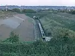 Severn Tunnel East Portal (BSW1101) |
| Dennisworth Farmhouse | Pucklechurch, South Gloucestershire | Farmhouse | Late 17th century | 17 September 1952 | ST6940576027 51°28′57″N 2°26′31″W |
1289567 | |
| Lyde Green Farmhouse | Lyde Green, Pucklechurch, South Gloucestershire | Farmhouse | mid-late 17th century | 17 September 1952 | ST6845377789 51°29′53″N 2°27′21″W |
1289408 | |
| Moat House | Pucklechurch, South Gloucestershire | Farmhouse | 17th century | 17 September 1952 | ST6970076714 51°29′19″N 2°26′16″W |
1212368 | |
| The Grey House | Pucklechurch, South Gloucestershire | House | 1678 | 17 September 1952 | ST6964076590 51°29′15″N 2°26′19″W |
1212709 | |
| Bagstone Court Farmhouse and Bakehouse 2m to South East | Bagstone, Rangeworthy, South Gloucestershire | Farmhouse | 14th century | 5 June 1984 | ST6901386891 51°34′48″N 2°26′55″W |
1137100 | |
| Church of the Holy Trinity | Rangeworthy, South Gloucestershire | Anglican Church | 1851 | 30 March 1960 | ST6866186248 51°34′27″N 2°27′13″W |
1116020 | 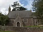 Church of the Holy Trinity |
| Rangeworthy Court | Rangeworthy, South Gloucestershire | House | Early 17th century | 21 October 1952 | ST6868286277 51°34′28″N 2°27′12″W |
1291208 | 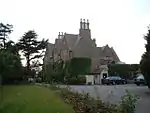 Rangeworthy Court |
| Church of St Oswald | Rockhampton, South Gloucestershire | Parish Church | 14th century | 30 March 1960 | ST6549593294 51°38′15″N 2°30′00″W |
1128960 | _St_Oswald's_Church_-_geograph.org.uk_-_68130.jpg.webp) Church of St Oswald |
| Little Brook Farmhouse | Goose Green, Siston, South Gloucestershire | Farmhouse | late 17th century or early 18th century | 3 April 1981 | ST6753974324 51°28′01″N 2°28′07″W |
1231436 | |
| Lodges to Siston Court | Siston Village, Siston, South Gloucestershire | Gate Lodge | Early 19th century | 11 May 1953 | ST6880675385 51°28′36″N 2°27′02″W |
1231513 | 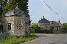 Lodges to Siston Court |
| Warmley House and Stable Block | Siston, South Gloucestershire | House | Mid 18th century | 11 May 1953 | ST6694672869 51°27′14″N 2°28′38″W |
1278069 | |
| Bank House | Chipping Sodbury, South Gloucestershire | House | Post World War Two | 17 September 1952 | ST7268682192 51°32′17″N 2°23′43″W |
1135952 | |
| Blanchard's Farmhouse | Chipping Sodbury, South Gloucestershire | Farmhouse | 15th century | 29 July 1983 | ST7378381756 51°32′03″N 2°22′46″W |
1129236 | |
| Home Farmhouse | Old Sodbury, Sodbury, South Gloucestershire | Farmhouse | Early-mid 17th century | 17 September 1952 | ST7558681073 51°31′41″N 2°21′12″W |
1320892 | |
| Lyegrove House | Lyegrove, Sodbury, South Gloucestershire | House | Early 17th century | 17 September 1952 | ST7764581674 51°32′01″N 2°19′25″W |
1136069 | |
| North Gateway to Dodington Park, Sites, Quadrant Walls and Chippenham Lodge and Terrace Walls | Old Sodbury, Sodbury, South Gloucestershire | Gate Lodge | Extension | 17 September 1952 | ST7596780931 51°31′36″N 2°20′52″W |
1135785 | |
| Parish Church of St John the Baptist | Old Sodbury, Chipping Sodbury, South Gloucestershire | Parish Church | Norman | 29 July 1983 | ST7555781803 51°32′05″N 2°21′14″W |
1320899 | 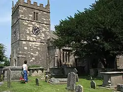 Parish Church of St John the Baptist |
| The George Hotel | Chipping Sodbury, South Gloucestershire | Inn Sign | 18th century | 17 September 1952 | ST7284382238 51°32′18″N 2°23′35″W |
1313103 | .JPG.webp) The George Hotel |
| The Grapes Hotel | Chipping Sodbury, South Gloucestershire | Hotel | 16th century | 17 September 1952 | ST7251382230 51°32′18″N 2°23′52″W |
1320881 | .JPG.webp) The Grapes Hotel |
| Tudor House | Sodbury, South Gloucestershire | House | Later | 17 September 1952 | ST7296982281 51°32′20″N 2°23′28″W |
1135891 | |
| 19 High Street | Sodbury, South Gloucestershire | House | Early 18th century | 17 September 1952 | ST7264182244 51°32′18″N 2°23′45″W |
1129263 | |
| 86 Broad Street | Sodbury, South Gloucestershire | House | 19th century | 17 September 1952 | ST7292282210 51°32′17″N 2°23′31″W |
1129254 | |
| 84 Broad Street | Sodbury, South Gloucestershire | House | Modern | 17 September 1952 | ST7291782210 51°32′17″N 2°23′31″W |
1129253 | |
| 17 High Street | Sodbury, South Gloucestershire | House | early-mid 17th century | 17 September 1952 | ST7262682239 51°32′18″N 2°23′46″W |
1135914 | |
| 28 High Street | Sodbury, South Gloucestershire | House | C18/C19 | 29 July 1983 | ST7270582181 51°32′16″N 2°23′42″W |
1313017 | |
| 1 High Street | Sodbury, South Gloucestershire | House | Late 17th century | 17 September 1952 | ST7257182231 51°32′18″N 2°23′49″W |
1313068 | |
| 15 High Street | Sodbury, South Gloucestershire | House | early-mid 17th century | 17 September 1952 | ST7262082246 51°32′18″N 2°23′46″W |
1320901 | |
| 26 High Street | Sodbury, South Gloucestershire | House | 16th century | 17 September 1952 | ST7269482186 51°32′16″N 2°23′42″W |
1320906 | |
| 29 Horse Street | Sodbury, South Gloucestershire | House | Mid 18th century | 17 September 1952 | ST7297682162 51°32′16″N 2°23′28″W |
1129279 | |
| 11 High Street | Sodbury, South Gloucestershire | House | Early 17th century | 17 September 1952 | ST7261382238 51°32′18″N 2°23′47″W |
1313032 | |
| Church of St Michael | Stoke Gifford, South Gloucestershire | Anglican Church | Mid 18th century | 26 June 1984 | ST6226179707 51°30′54″N 2°32′43″W |
1128831 | 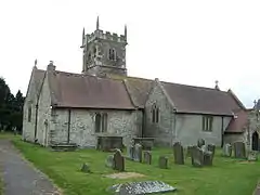 Church of St Michael |
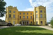
| Dower House | Stoke Park, Stoke Gifford, South Gloucestershire | Country House | c. 1760 | 26 June 1984 | ST6223377251 51°29′35″N 2°32′43″W |
1136240 | |
| Bristol and West Building Society | Thornbury, South Gloucestershire | House | late C18/early 19th century | 21 September 1952 | ST6365889969 51°36′27″N 2°31′34″W |
1136819 | |
| Clematis Cottage | Thornbury, South Gloucestershire | House | 16th century | 21 September 1952 | ST6359790307 51°36′37″N 2°31′38″W |
1312688 | |
| Morton Grange | Upper Morton, Thornbury, South Gloucestershire | House | 1594 | 17 December 1984 | ST6493291385 51°37′13″N 2°30′29″W |
1128792 | |
| Porch House | Thornbury, South Gloucestershire | House | Late 16th century | 30 March 1960 | ST6360990271 51°36′36″N 2°31′37″W |
1321130 | |
| The Priory | Thornbury, South Gloucestershire | House | 15th century | 21 September 1952 | ST6358990316 51°36′38″N 2°31′38″W |
1128787 | |
| Old Manor House | West Littleton, Tormarton, South Gloucestershire | House | c. 1500 | 15 August 1985 | ST7620775467 51°28′40″N 2°20′38″W |
1288609 | |
| Churchyard Cross 7m North of Porch of St Leonard's Church | Tortworth, South Gloucestershire | Cross | 14th century | 5 June 1984 | ST7043393353 51°38′18″N 2°25′43″W |
1115014 | |
| Leyhill Officers' Training School | Tortworth Park, Tortworth, South Gloucestershire | Country House | 1849-1853 | 5 June 1984 | ST6933192514 51°37′50″N 2°26′40″W |
1136903 | |
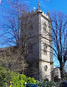
| Parish Church of St Leonard | Tortworth, South Gloucestershire | Anglican Church | 1872 | 5 June 1984 | ST7043293335 51°38′17″N 2°25′43″W |
1115013 | 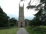 Parish Church of St Leonard |
| Church of St James | Tytherington, South Gloucestershire | Anglican Church | 1884 | 25 September 1985 | ST6685688374 51°35′36″N 2°28′47″W |
1321032 | 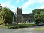 Church of St James |
| Church of St Saviour | Coalpit Heath, Westerleigh, South Gloucestershire | Parish Church | 1844-5 | 18 November 1981 | ST6737280760 51°31′29″N 2°28′18″W |
1288167 | 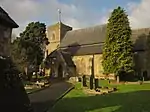 Church of St Saviour |
| Lychgate and attached Walls about 30m East of Church of St Saviour | Coalpit Heath, Westerleigh, South Gloucestershire | Lych Gate | 1844-5 | 18 November 1981 | ST6738180709 51°31′28″N 2°28′18″W |
1288247 | 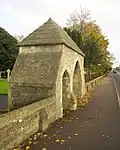 Lychgate and attached Walls about 30m East of Church of St Saviour |
| Old Vicarage | Coalpit Heath, Westerleigh, South Gloucestershire | House | 1900 | 18 November 1981 | ST6728580738 51°31′29″N 2°28′23″W |
1288128 | |
| Church of St Bartholomew | Wick and Abson, South Gloucestershire | Parish Church | 1845 | 15 August 1985 | ST6963472754 51°27′11″N 2°26′18″W |
1216152 | 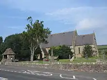 Church of St Bartholomew |
| Coachhouse and Stables 15m to North East of Oxwick Farmhouse | Wickwar, South Gloucestershire | Tack Room | 1722 | 17 September 1952 | ST7220685947 51°34′18″N 2°24′09″W |
1312305 | |
| Frith Farmhouse and Bakehouse at South East | Wickwar, South Gloucestershire | Farmhouse | 17th century | 17 September 1952 | ST7178287361 51°35′04″N 2°24′31″W |
1128768 | 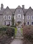 Frith Farmhouse and Bakehouse at South East |
| Oxwick Farmhouse | Wickwar, South Gloucestershire | Farmhouse | 1722 | 17 September 1952 | ST7218885905 51°34′17″N 2°24′10″W |
1321124 | 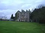 Oxwick Farmhouse |
| Parish Church of the Holy Trinity | Wickwar, South Gloucestershire | Anglican Church | c. 1881 | 3 March 1961 | ST7234888921 51°35′54″N 2°24′02″W |
1137110 | 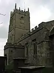 Parish Church of the Holy Trinity |
| Court Farm Barn | Winterbourne, South Gloucestershire | Barn | 16th century or earlier | 12 February 1979 | ST6411680931 51°31′34″N 2°31′07″W |
1128852 | |
| Faber's Farmhouse | Hambrook, Winterbourne, South Gloucestershire | Farmhouse | Late Medieval | 17 September 1952 | ST6383378859 51°30′27″N 2°31′21″W |
1276726 | |
| Frenchay Manor | Frenchay, Winterbourne, South Gloucestershire | House | 1736 | 17 September 1952 | ST6412478108 51°30′03″N 2°31′06″W |
1128838 |  Frenchay Manor |
| Moorend Farmhouse | Moorend, Winterbourne, South Gloucestershire | Farmhouse | 1676 | 17 September 1952 | ST6510878994 51°30′32″N 2°30′15″W |
1276739 | |
| Unitarian Chapel | Frenchay, Winterbourne, South Gloucestershire | Unitarian Chapel | 1720 | 3 March 1961 | ST6397277592 51°29′46″N 2°31′13″W |
1233019 | 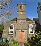 Unitarian Chapel |
| Church of St James | Mangotsfield, South Gloucestershire | Parish Church | 13th century | 24 April 1951 | ST6644876177 51°29′01″N 2°29′04″W |
1116192 | _St_James_Church_-_geograph.org.uk_-_68107.jpg.webp) Church of St James |
| Hill House | Mangotsfield, South Gloucestershire | House | c. 1700 | 24 April 1951 | ST6570576050 51°28′56″N 2°29′43″W |
1320081 | |
| Parish Church of the Holy Trinity and Churchyard Walls Fronting Street and on West, Running Southwards for Approximately 100 Yards | Kingswood, South Gloucestershire | Church | 1821 | 6 June 1951 | ST6509473800 51°27′44″N 2°30′14″W |
1319749 |
Notes
- The date given is the date used by Historic England as significant for the initial building or that of an important part in the structure's description.
- Sometimes known as OSGB36, the grid reference is based on the British national grid reference system used by the Ordnance Survey.
- The "List Entry Number" is a unique number assigned to each listed building and scheduled monument by Historic England.
External links
![]() Media related to Grade II* listed buildings in Gloucestershire at Wikimedia Commons
Media related to Grade II* listed buildings in Gloucestershire at Wikimedia Commons
This article is issued from Wikipedia. The text is licensed under Creative Commons - Attribution - Sharealike. Additional terms may apply for the media files.