Horní Loděnice
Horní Loděnice, until 1950 Německá Loděnice (German: Deutsch Lodenitz) is a village and municipality (obec) in Olomouc District in the Olomouc Region of the Czech Republic.
Horní Loděnice | |
|---|---|
Municipality | |
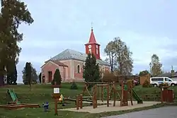 Church of Saint Isidore | |
 Flag  Coat of arms | |
 Horní Loděnice | |
| Coordinates: 49°46′12″N 17°21′59″E | |
| Country | |
| Region | Olomouc |
| District | Olomouc |
| Area | |
| • Total | 18.18 km2 (7.02 sq mi) |
| Elevation | 543 m (1,781 ft) |
| Population (2006) | |
| • Total | 352 |
| • Density | 19/km2 (50/sq mi) |
| Postal code | 783 05 |
| Website | http://www.hornilodenice.cz |
The municipality covers an area of 18.18 square kilometres (7.02 sq mi), and has a population of 352 (as at 3 July 2006).
Horní Loděnice lies approximately 22 kilometres (14 mi) north-east of Olomouc and 214 km (133 mi) east of Prague.
Gallery
 Playground
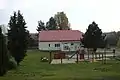
 Road
Road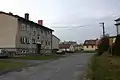 Houses
This article is issued from Wikipedia. The text is licensed under Creative Commons - Attribution - Sharealike. Additional terms may apply for the media files.