Jackson County, Kentucky
Jackson County is a county located in the Commonwealth of Kentucky. As of the 2010 census, the population was 13,494.[1] Its county seat is McKee.[2] The county was formed in 1858 from land given by Madison, Estill, Owsley, Clay, Laurel, and Rockcastle counties.[3] It was named for Andrew Jackson, seventh President of the United States.[4] Jackson County is a moist county which means that the county seat, McKee, allows the sale of alcohol.
Jackson County | |
|---|---|
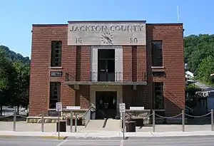 Jackson County courthouse in McKee | |
| Motto(s): Where the Mountains and the Bluegrass Blend | |
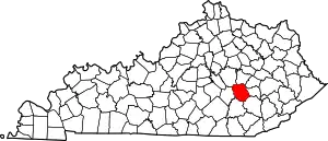 Location within the U.S. state of Kentucky | |
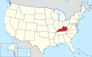 Kentucky's location within the U.S. | |
| Coordinates: 37°25′N 84°01′W | |
| Country | |
| State | |
| Founded | 1858 |
| Named for | Andrew Jackson |
| Seat | McKee |
| Largest community | Annville |
| Government | |
| • Judge Executive | Shane Gabbard (R) |
| Area | |
| • Total | 347 sq mi (900 km2) |
| • Land | 345 sq mi (890 km2) |
| • Water | 1.3 sq mi (3 km2) 0.4%% |
| Population | |
| • Estimate (2018) | 13,442 |
| • Density | 39/sq mi (15/km2) |
| ZIP Codes | 40447, 40402, 40434, 40481, 40486 |
| Congressional district | 5th |
One fourth of Jackson County is Daniel Boone National Forest (56,000 acres), making it representative of Eastern Kentucky's unique Appalachian topography, wildlife, and heritage. Jackson County is the birthplace of the Grand Ole Opry star “Stringbean” Akemon, and the site of the annually reenacted Battle of Big Hill, the Civil War skirmish that led to the Battle of Richmond in Madison County. Jackson County is home to many attractions and recreation spots such as Flat Lick Falls, S-Tree Campground, Turkey Foot Campground, and the centermost trailhead (located in the county seat, McKee) of the historic Sheltowee Trace.[5]
Geography and outdoor recreation
National recreation areas
S-Tree Campground sits on a ridge above Horse Lick Creek near McKee in Jackson County, KY. A small picnic area features a historic picnic shelter that was constructed in the 1930s by the Civilian Conservation Corps. The campground receives heavy weekend use from off-highway vehicle users who ride the adjacent Sheltowee Trace National Recreation Trail and the Renfro Loop Trail. These trails may be accessed from the campground.[6]
Turkey Foot Campground is nestled along the banks of War Fork Creek in Jackson County, KY. The creek is stocked with trout throughout the year. All of the campsites are wooded. A playfield with a horseshoe pit is located at the end of camping sites alongside the creek. Trails include the Turkey Foot Loop Trail and the Sheltowee Trace National Recreation Trail.[7]
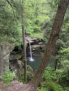
Flat Lick Falls is tucked into the hills of southern Jackson County and consists of recreational facilities which include primitive camping, picnic shelters, and restrooms. The park features 86.09 acres of wooded land, cliffs and Flat Lick creek running through the middle of the park with a 28-foot water fall emptying into a large pool at the bottom of the falls. The creek flows into the Laurel Fork Creek. The falls can be viewed up close via the meandering paths along the cliff line including a paved path leading to a wheelchair accessible viewing platform.[8]
Sheltowee Trace National Recreation Trail is over 300 miles of National Recreation Trail, established in 1979, in the Appalachian region of the Eastern U.S., and reaches from northern Rowan County, Kentucky to the Leather Wood Trail Head in the Big South Fork National River and Recreation Area just across the Tennessee border. The Trail runs mostly through the Daniel Boone National Forest, and is named for the Shawnee word for “Big Turtle”, which was the name given to Daniel Boone in 1779 when he was adopted as the son of the great warrior chief Blackfish. Jackson County encompasses approximately 35 miles of the Sheltowee Trace, which is open to hiking, horseback riding, and mountain bikes. Some sections also allow all-terrain vehicles.[9]
Public parks
- Bond Memorial Park
- Jack Gabbard Park
- McKee City Park
- Gray Hawk Community Park
- Sand Gap Community Park
- Worthington Park
- Jackson Energy Farm/Recreational Fields
Lakes and reservoirs
- Beulah Lake
- Owsley Fork Reservoir
- McKee Reservoir
Major highways
- US Highway 421
- KY Highway 30
- KY Highway 290
- KY Highway 3630 (Old KY Highway 30)
US Highway 421 serves as the county's north–south corridor, connecting it to Madison County, the cities of Richmond and Berea , and I-75 to the north. While the southern corridor connects the county to Clay County, the city of Manchester, and the Hal Rogers Parkway. This route also connects the communities of Sandgap, McKee and Tyner.
KY Highway 30 serves as the main east–west corridor, passing through the southern part of the county. It connects the county to Laurel County, London, and I-75 to the west, Owsley County and Booneville to the east. KY 30 is being reconstructed as part of a corridor between I-75 and the Mountain Parkway which will connect the county to Lee and Powell Counties.[10] The route between Tyner and London has already been reconstructed, replacing the current KY 3630.
KY Highway 290 connects US 421 in McKee to KY 3630 in Annville.
Adjacent counties
- Estill County (north)
- Lee County (northeast)
- Owsley County (east)
- Clay County (southeast)
- Laurel County (southwest)
- Rockcastle County (west)
- Madison County (northwest)
National protected areas
- Daniel Boone National Forest (part)
- Mill Creek Wildlife Management Area
Arts, Culture, and Events
Jackson County Fair & Homecoming
This event is held annually on the Friday and Saturday before Labor Day. Activities include a show, craft exhibits, musical entertainment, clogging, vendors, food trucks, and a parade.[11]
Sheltowee Trace Artisans Fair
Local and guest artisans from across the state and beyond come to teach, demonstrate, and sell their crafts at this event, which is held during the first weekend in May.[11]
Battle of Big Hill Reenactment
The reenactment takes place the third weekend of August at the Jackson Energy Farm on HWY 290, about 6 miles south of McKee. A family-friendly outdoor event, reenactments generally take place over two days, and consist of games, historical speakers, a ladies and gentlemen's tea, food, and music before the actual battle. After dark, couples can follow the cues of the square dancing caller at the Civil War Ball, featuring local musicians playing songs from the era.[12]
Stringbean Music Festival
Most people remember David "Stringbean" Akemon from the old television show "Hee-Haw" but folks in Jackson County knew him as brother, uncle, and friend. Although a famous performer, "Stringbean" returned often to his home in Jackson County. In June 1996, Porter Wagoner, Grandpa & Ramona Jones, Mac Wiseman and a host of other entertainers and friends gathered to unveil a larger than life statue of Stringbean, and established a memorial in his honor. Since then, the festive has grown tremendously. Today, two festivals are held - one in June and one in October - and both feature nationally known bluegrass music performers, as well as mountain arts and crafts.[13]
Economy
Major employers in Jackson County include:
- Jackson County Public Schools
- People's Rural Telephone Cooperative (PRTC)
- Jackson Energy
- Phoenix Products
- Clover Bottom Quarry
- Phillips Diversified Manufacturing
- Senture
- Teleworks USA
Utilities
Jackson County is served by Jackson Energy, which is based in the City of McKee, and serves Jackson County and surrounding counties such as Lee County, Owsley County, Clay County, Laurel County, Rockcastle County, and Madison County. Jackson County, Owsley County, and Clay County are served by Peoples Rural Telephone Cooperative, also based in the City of McKee. Water is provided by the Jackson County Water Association and garbage pickup is provided by Woods Sanitation. Residents within the City of McKee are served by McKee Waterworks and McKee Sewer.
Healthcare
Jackson County does not have a hospital. Nearby facilities include Saint Joseph Hospital (Berea), Baptist Health Hospital (Richmond), Manchester Memorial Hospital (Manchester), and Saint Joseph Hospital (London).
Emergency medical services for Jackson County are provided by the Jackson County Ambulance Service; they provide 24/7 Advanced Life Support and Basic Life Support emergency services to all citizens and visitors of Jackson County.
Jackson County has a few primary care facilities which include the White House Clinic, McKee Medical Clinic, and Annville Medical Clinic.
Demographics
| Historical population | |||
|---|---|---|---|
| Census | Pop. | %± | |
| 1860 | 3,087 | — | |
| 1870 | 4,547 | 47.3% | |
| 1880 | 6,678 | 46.9% | |
| 1890 | 8,261 | 23.7% | |
| 1900 | 10,561 | 27.8% | |
| 1910 | 10,734 | 1.6% | |
| 1920 | 11,687 | 8.9% | |
| 1930 | 10,467 | −10.4% | |
| 1940 | 16,339 | 56.1% | |
| 1950 | 13,101 | −19.8% | |
| 1960 | 10,677 | −18.5% | |
| 1970 | 10,005 | −6.3% | |
| 1980 | 11,996 | 19.9% | |
| 1990 | 11,955 | −0.3% | |
| 2000 | 13,495 | 12.9% | |
| 2010 | 13,494 | 0.0% | |
| 2018 (est.) | 13,442 | [14] | −0.4% |
| U.S. Decennial Census[15] 1790-1960[16] 1900-1990[17] 1990-2000[18] 2010-2013[1] | |||
As of the 2010 census[19] there were 13,494 people and 5,455 households in the county. The population density was 39 per square mile (15/km2). There were 6,643 housing units. The racial makeup of the county was 98.6% White, which makes it the whitest county in Kentucky.[20] The remaining are 0.03% Black or African American, 0.20% Native American, 0.01% Asian, 0% Pacific Islander, 0.70% from two or more races, and 0.90% Hispanic or Latino of any race.[19]
28.60% of the population are under the age of 18 and 18.1% of the population are 65 years of age or older. There are 514 veterans residing within the county.[19]
The median income for a household in the county was $32,143. The per capita income for the county was $17,692. About 26.50% of the population are below the poverty line.[19]
The median value for housing units is $78,200 and the average rent is $524 a month.[19]
74.3% of the population has a high school education or higher. 12.2% of the population has a bachelor's degree or higher. 77.7% of households have a computer and 65.1% have a broadband internet subscription.[19]
Politics
National politics
In presidential elections, Jackson County has voted Republican since the Civil War and has never voted Democratic.[21] Lyndon Johnson in 1964 and Bill Clinton in 1996 are the only Democratic candidates to ever win as much as 20% of the county's vote. The only time Jackson County has not voted for the Republican Party was in its first election of 1860 when the county went to Constitutional Unionist John Bell, and in 1912 when the Republican Party was split and third party candidate Theodore Roosevelt carried the county with 52 percent of the vote over William Howard Taft with 34 percent.
Jackson County has a strong history of giving Republican candidates some of their highest winning percentages in the nation. This was the case in the 1928, 1948,[22] 1960,[23] 1976,[24] 1988,[25] and 1992 presidential elections.[26] In 1992 Jackson County, along with Sioux County, Iowa, were the only two counties in the U.S to vote for Republican George H. W. Bush by over 70 percent in his re-election campaign.[26] Additionally, Republican Alf Landon, who lost 46 of 48 states, received over 89 percent of Jackson County's vote in 1936.[27]
| Year | Republican | Democratic | Third parties |
|---|---|---|---|
| 2020 | 89.2% 5,450 | 9.9% 605 | 0.9% 55 |
| 2016 | 88.9% 4,889 | 8.8% 482 | 2.4% 130 |
| 2012 | 86.3% 4,365 | 12.1% 612 | 1.7% 84 |
| 2008 | 84.4% 4,407 | 14.2% 743 | 1.4% 74 |
| 2004 | 84.4% 4,369 | 14.9% 769 | 0.8% 40 |
| 2000 | 84.0% 4,079 | 14.4% 701 | 1.5% 75 |
| 1996 | 70.0% 3,045 | 22.1% 960 | 8.0% 346 |
| 1992 | 75.0% 3,398 | 17.1% 776 | 7.9% 359 |
| 1988 | 85.2% 3,926 | 14.7% 678 | 0.1% 6 |
| 1984 | 87.4% 3,856 | 12.3% 542 | 0.3% 15 |
| 1980 | 82.0% 3,379 | 17.0% 702 | 1.0% 42 |
| 1976 | 79.8% 2,766 | 19.6% 680 | 0.6% 20 |
| 1972 | 92.2% 5,303 | 7.6% 436 | 0.2% 14 |
| 1968 | 84.1% 3,098 | 8.3% 304 | 7.7% 282 |
| 1964 | 73.8% 2,654 | 25.6% 920 | 0.6% 23 |
| 1960 | 90.4% 3,923 | 9.7% 419 | |
| 1956 | 88.4% 3,950 | 11.2% 501 | 0.5% 20 |
| 1952 | 86.8% 3,104 | 13.2% 471 | 0.1% 3 |
| 1948 | 86.0% 2,781 | 13.3% 429 | 0.7% 24 |
| 1944 | 91.6% 3,578 | 8.4% 328 | 0.1% 2 |
| 1940 | 88.6% 3,722 | 11.1% 465 | 0.3% 13 |
| 1936 | 89.1% 3,440 | 10.9% 420 | 0.1% 3 |
| 1932 | 84.3% 2,879 | 15.5% 529 | 0.2% 8 |
| 1928 | 96.5% 3,552 | 3.3% 123 | 0.1% 5 |
| 1924 | 88.0% 2,629 | 9.5% 284 | 2.5% 76 |
| 1920 | 92.2% 3,174 | 7.6% 260 | 0.3% 10 |
| 1916 | 87.9% 1,968 | 11.3% 252 | 0.9% 19 |
| 1912 | 34.1% 577 | 12.8% 216 | 53.1% 897 |
Local & State Politics
Jackson County is part of Kentucky's 5th Congressional District, which is represented by Republican Hal Rogers. In the Kentucky House of Representatives, the county is in the 89th District and is represented by Republican Robert Goforth. In the Kentucky Senate, the county is in the 21st District and is represented by Republican Albert Robinson.
Prohibition
The entirety of Jackson County prohibited the sale of alcoholic beverages from the years 1937 until 2019 when the City of McKee held a vote during the 2019 General Election regarding the ability for the city to grant licenses to businesses for selling alcoholic beverages. The vote's results were 100 in favor of selling alcohol to 81, who were not. [29]
Education
Public Education
The county is served by Jackson County Public Schools which operates the following schools:
- McKee Elementary
- Sand Gap Elementary
- Tyner Elementary
- Jackson County Middle School
- Jackson County High School
In the county is also the Annville Christian Academy (K-12).
Higher Education
There are no higher education institutes within the county, but some nearby universities and colleges include:
- Berea College
- Eastern Kentucky University
- Somerset Community College (London Campus)
Public Library
Jackson County has a lending library, the Jackson County Public Library, located in the City of McKee.
Notable people
- David "Stringbean" Akeman, country music star[30]
- Freddie Langdon, world champion fiddler
- Andrew N. Johnson, 1944 nominee for vice president of the United States
See also
References
- "State & County QuickFacts". United States Census Bureau. Archived from the original on June 7, 2011. Retrieved March 8, 2014.
- "Find a County". National Association of Counties. Archived from the original on May 31, 2011. Retrieved 2011-06-07.
- Rennick, Robert M. (1987). Kentucky Place Names. University Press of Kentucky. p. 151. ISBN 0813126312. Retrieved 2013-07-26.
- The Register of the Kentucky State Historical Society, Volume 1. Kentucky State Historical Society. 1903. pp. 35.
- Jackson County Tourism. "About". Jackson County Tourism.
- "S-Tree Campground". USDA Forest Service: Daniel Boone National Forest.
- "Turkey Foot Campground". USDA Forest Service- Daniel Boone National Forest.
- "Flat Lick Falls". Jackson County Kentucky Tourism.
- Jackson County Tourism. "Hiking". Jackson County Tourism.
- "Construction on Final Stretch of KY 30 Beginning Soon". Hal Rogers. July 26, 2019. Retrieved 20 October 2020.
- Jackson County Tourism. "Fairs and Festivals". Jackson County Tourism.
- Jackson County Tourism. "Civil War History". Jackson County Tourism.
- Jackson County Tourism. "Stringbean Memorial Park". Jackson County Tourism.
- "Population and Housing Unit Estimates". Retrieved July 29, 2019.
- "U.S. Decennial Census". United States Census Bureau. Retrieved August 16, 2014.
- "Historical Census Browser". University of Virginia Library. Retrieved August 16, 2014.
- "Population of Counties by Decennial Census: 1900 to 1990". United States Census Bureau. Retrieved August 16, 2014.
- "Census 2000 PHC-T-4. Ranking Tables for Counties: 1990 and 2000" (PDF). United States Census Bureau. Retrieved August 16, 2014.
- "U.S. Census Bureau".
- "Kentucky White Population Percentage by County".
- Marshall, Anne E. Creating a Confederate Kentucky: The Lost Cause and Civil War Memory in a Border State, pp. 114-115. ISBN 1469609835
- "David Leip's Presidential Election Atlas – 1948 statistics". Uselectionatlas.org. Retrieved November 13, 2011.
- "David Leip's Presidential Election Atlas – 1960 statistics". Uselectionatlas.org. Retrieved November 13, 2011.
- "David Leip's Presidential Election Atlas – 1976 statistics". Uselectionatlas.org. Retrieved November 13, 2011.
- "David Leip's Presidential Election Atlas – 1988 statistics". Uselectionatlas.org. Retrieved November 13, 2011.
- "David Leip's Presidential Election Atlas – 1992 statistics". Uselectionatlas.org. Retrieved November 13, 2011.
- "David Leip's Presidential Election Atlas – 1936 statistics". Uselectionatlas.org. Retrieved November 13, 2011.
- Leip, David. "Dave Leip's Atlas of U.S. Presidential Elections". uselectionatlas.org. Retrieved 2018-07-03.
- "Liquor Licenses Granted: Alcohol Sales Now Authorized in McKee". Jackson County Sun. May 22, 2020. Retrieved 20 October 2020.
- "Murder in the Kornfield: The Life and Death of Stringbean". WFMU's Beware of the Blog.
External links
- Official Government Website of Jackson County, Kentucky
- Official Tourism Website of Jackson County, Kentucky
- Official Website of Jackson County Public Schools
- Official Website of Annville Christian Academy
Municipalities and communities of Jackson County, Kentucky, United States | ||
|---|---|---|
| City | Location of Jackson County, Kentucky | |
| CDP | ||
| Unincorporated communities | ||
| Ghost towns | ||
| ||

| Authority control |
|---|