Japan National Route 101
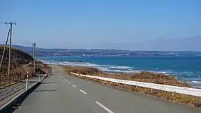
National Route 101 (国道101号, Kokudō Hyakuichigō) is a national highway of Japan connecting the capitals of Aomori and Akita prefectures, Aomori and Akita in northern Japan, with a total length of 241.6 kilometers (150.1 mi). The majority of the highway travels along the coast of the Sea of Japan, often paralleling National Route 7.
| ||||
|---|---|---|---|---|
| 国道101号 | ||||
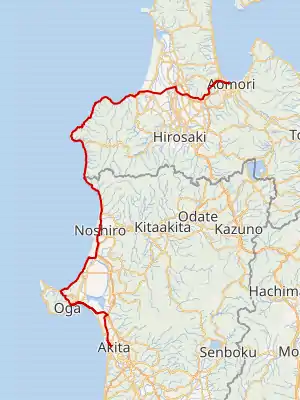
National Route 101 highlighted in red | ||||
 | ||||
| Route information | ||||
| Length | 241.6 km[1] (150.1 mi) | |||
| Major junctions | ||||
| North end | ||||
| South end | ||||
| Highway system | ||||
| National highways of Japan Expressways of Japan
| ||||

History
National Route 101 was established by the Cabinet of Japan between the city of Aomori and Noshiro, Akita in 1953.[2] In 1993, the northern terminus of the highway was moved south from Noshiro to its current location in the city of Akita.[3]
On 28 December 2018, Oibanasaki Tunnel in Oga, Akita was closed because the risk of a landslide was deemed too high. The tunnel is scheduled to be reopened in 2020.[4]
Major intersections
| Prefecture | Location | km | mi | Destinations | Notes | ||
|---|---|---|---|---|---|---|---|
| Aomori | Aomori | 0.0 | 0.0 | Northern terminus; northern end of Route 7 concurrency (Route 101 is unsigned) | |||
| 0.2 | 0.12 | Aomori Route 120 north | Southern end of Aomori Route 120 concurrency | ||||
| 0.4 | 0.25 | Aomori Route 44 east (Aomori-Nonai Loop Road) | |||||
| 0.9 | 0.56 | ||||||
| 1.4 | 0.87 | Aomori Route 247 west | Interchange | ||||
| 4.4 | 2.7 | ||||||
| 5.4 | 3.4 | Aomori Route 234 | Interchange | ||||
| 7.5 | 4.7 | ||||||
| 9.3 | 5.8 | Aomori Route 247 | |||||
| 14.9 | 9.3 | Aomori Route 247 east | |||||
| 16.6 | 10.3 | Southern end of Route 7 concurrency | |||||
| 18.3 | 11.4 | Aomori Route 285 south | |||||
| 18.8 | 11.7 | ||||||
| 19.5 | 12.1 | Aomori Route 231 east | |||||
| Goshogawara | 21.7 | 13.5 | Aomori Route 35 south | ||||
| 24.8 | 15.4 | Aomori Route 34 south | |||||
| 25.5 | 15.8 | Aomori Route 36 north | |||||
| 27.2 | 16.9 | Goshogawara-higashi Interchange | |||||
| 27.4 | 17.0 | Aomori Route 156 north | |||||
| 29.4 | 18.3 | Aomori Route 38 south | |||||
| 31.8 | 19.8 | ||||||
| 32.7 | 20.3 | ||||||
| 33.1 | 20.6 | Aomori Route 154 west / Aomori Route 156 east | |||||
| 34.2 | 21.3 | Aomori Route 151 north | |||||
| 35.2 | 21.9 | Aomori Route 43 north | |||||
| Tsugaru | 36.1 | 22.4 | Tsugaru Kashiwa Interchange | ||||
| 36.7 | 22.8 | Aomori Route 245 west | |||||
| 38.0 | 23.6 | Aomori Route 37 south / Aomori Route 241 north | |||||
| 39.7 | 24.7 | Aomori Route 186 | |||||
| 42.0 | 26.1 | Aomori Route 245 east / Aomori Route 267 west | |||||
| 44.1 | 27.4 | Aomori Route 188 | |||||
| 45.3 | 28.1 | Aomori Route 39 south | |||||
| 47.5 | 29.5 | Aomori Route 12 north | |||||
| 49.0 | 30.4 | ||||||
| Ajigasawa | 49.4 | 30.7 | Aomori Route 267 east | ||||
| 52.6 | 32.7 | Aomori Route 31 south | |||||
| 53.3 | 33.1 | Current westerm terminus of the Tsugaru Expressway | |||||
| 55.5 | 34.5 | Aomori Route 3 | |||||
| 60.1 | 37.3 | Aomori Route 3 east | |||||
| Fukaura | 65.0 | 40.4 | Aomori Route 191 south | ||||
| 93.9 | 58.3 | Aomori Route 192 south | |||||
| 107.3 | 66.7 | Aomori Route 192 north | |||||
| 108.5 | 67.4 | Aomori Route 28 east | |||||
| 112.2 | 69.7 | Aomori Route 280 east | |||||
| Akita | Happō | 134.1 | 83.3 | Akita Route 154 south | |||
| 137.9 | 85.7 | Akita Route 154 north | |||||
| 142.3 | 88.4 | Akita Route 63 south | |||||
| Noshiro | 150.6 | 93.6 | Akita Route 209 north | ||||
| 152.8 | 94.9 | Akita Route 143 east | |||||
| 157.6 | 97.9 | Northern end of Route 7 concurrency | |||||
| 162.2 | 100.8 | Continuous green T interchange; Akita Expressway exit 13 (Noshiro-minami Interchange) | |||||
| Mitane | 166.9 | 103.7 | Continuous green T interchange; Akita Expressway exit 12 (Hachiryū Interchange) | ||||
| 167.9 | 104.3 | Southern end of Route 7 concurrency | |||||
| 169.3 | 105.2 | Akita Route 42 south | |||||
| Oga | 190.5 | 118.4 | Akita Route 304 east | ||||
| 195.7 | 121.6 | Akita Route 55 west | Northern end of Akita Route 55 concurrency | ||||
| 199.2 | 123.8 | Akita Route 55 east | Southern end of Akita Route 55 concurrency | ||||
| 204.6 | 127.1 | Akita Route 59 | |||||
| 208.0 | 129.2 | Akita Route 226 | |||||
| 210.4 | 130.7 | Akita Route 42 north | |||||
| 212.0 | 131.7 | Akita Route 159 north | |||||
| Katagami | 219.2 | 136.2 | Akita Route 56 south | ||||
| Akita | 224.7 | 139.6 | Northern end of Route 7 concurrency; Continuous green T interchange; Akita Expressway exit 9 (Shōwa-Ogahantō Interchange) | ||||
| Katagami | 225.2 | 139.9 | Akita Route 41 south | ||||
| 229.4 | 142.5 | Akita Route 124 east | |||||
| Akita | 234.1 | 145.5 | Akita Route 112 north | ||||
| 234.3 | 145.6 | Akita Route 56 north (Ohama Street) | Northern end of Akita Route 56 concurrency | ||||
| 235.8 | 146.5 | Akita Route 231 east | |||||
| 237.5 | 147.6 | Akita Route 56 south | Southern end of Akita Route 56 concurrency | ||||
| 240.1 | 149.2 | Akita Route 65 south | |||||
| 241.6 | 150.1 | Southern terminus; southern end of Route 7 concurrency | |||||
1.000 mi = 1.609 km; 1.000 km = 0.621 mi
| |||||||
See also
 Japan portal
 Roads portal
References
- "一般国道の路線別、都道府県別道路現況" [Road statistics by General National Highway route and prefecture] (PDF) (in Japanese). Ministry of Land, Infrastructure, Transport and Tourism. Retrieved 19 February 2020.
- "一般国道の路線を指定する政令" (in Japanese). Retrieved 18 October 2019 – via Wikisource.
- "一般国道の路線を指定する政令の一部を改正する政令". 3 April 1992. Archived from the original on 4 February 2013. Retrieved 18 October 2019.
- "国道101号生鼻崎トンネルの通行規制関係" (in Japanese). 28 December 2018. Retrieved 18 October 2019.
External links
 Media related to Category:Route 101 (Japan) at Wikimedia Commons
This article is issued from Wikipedia. The text is licensed under Creative Commons - Attribution - Sharealike. Additional terms may apply for the media files.