Jomala
Jomala is a municipality of Åland, an autonomous territory of Finland. In terms of population, it is the next largest after Mariehamn, the capital of Åland.
Jomala | |
|---|---|
Municipality | |
| Jomala kommun | |
 "Welcome to Jomala." The coat of arms of Jomala features St. Olav sitting on a throne and holding an axe and a globus cruciger | |
 Coat of arms | |
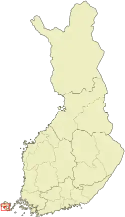 Location of Jomala in Finland | |
 Jomala Location in Åland | |
| Coordinates: 60°09′N 019°57′E | |
| Country | |
| Region | Åland |
| Sub-region | Åland Countryside sub-region |
| Government | |
| • Municipal manager | Christian Dreyer |
| Area (2018-01-01)[1] | |
| • Total | 687.00 km2 (265.25 sq mi) |
| • Land | 142.53 km2 (55.03 sq mi) |
| • Water | 544.43 km2 (210.21 sq mi) |
| Area rank | 282nd largest in Finland |
| Population (2020-07-31)[2] | |
| • Total | 5,306 |
| • Rank | 164th largest in Finland |
| • Density | 37.23/km2 (96.4/sq mi) |
| Population by native language | |
| • Swedish | 92.1% (official) |
| • Finnish | 4.7% |
| • Others | 3.2% |
| Population by age | |
| • 0 to 14 | 20.6% |
| • 15 to 64 | 67.1% |
| • 65 or older | 12.3% |
| Time zone | UTC+02:00 (EET) |
| • Summer (DST) | UTC+03:00 (EEST) |
| Municipal tax rate[5] | 17% |
| Website | www.jomala.ax |

The municipality has a population of 5,306 (31 July 2020)[2] and covers an area of 687.00 square kilometres (265.25 sq mi) of which 544.43 km2 (210.21 sq mi) is water.[1] The population density is 37.23 inhabitants per square kilometre (96.4/sq mi).
The municipality is unilingually Swedish.
Mariehamn Airport is located in Jomala. Three of Åland's four highways cross the municipality of Jomala as they start from Mariehamn; highway 1 runs west to Eckerö, highway 2 northeast to Sund and highway 3 east to Lumparland.
History
"Jomala" is the name of a god common to many Finno-Ugric peoples. Jumala is Finnish for god and Jomala is one of the sites where Christian church organized itself in Finland. Other versions of the name that have occurred are Jwmala 1356, Jomalum 1414, Jomala 1486 and Jwmala 1494. One of oldest churches in Finland stands here as testament to these times.
Jomala was inhabited around 2000 B.C with Jettböle being one of the most renowned prehistoric sites. Other ancient sites include Borgberget, where there was a Viking fortress, and Kasberget which was one of the many mountains where signal fires were lit when enemies were seen approaching.
Before the city of Mariehamn was established in 1861, the peninsula where the city is situated was a part of Jomala.
Sights


The church of Jomala is dedicated to the patron saint of Åland, St. Olav. It is the oldest surviving church in Finland[6] and it is situated in the village of Prästgården. The oldest parts of the church date from the 13th century. The church tower is 52 meters tall and there is also a memorial for all the Ålanders who emigrated. Another memorial refers to sailors who lost their lives on sea. The "King of Åland" Julius Sundblom is buried here. A large medieval cemetery with graves from the Iron Age can be visited behind the church.
The Lemström channel divides Jomala from its neighboring municipality, Lemland. It was widened by Russian POWs in 1882.
The Kungsö battery was one of the ten coastal batteries which the Russians built in Åland during the First World War in 1916. The battery was situated 32 meters above sea level, on the highest point of Dalsberg. Finnish, Swedish and German troops invaded it in 1918. It was dismantled in 1919 by Finnish civilian workers.
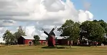
There are various well-preserved windmills in Jomala, e.g. on Norrgård farm in Björsby.[7]
Culture
Since Jomala belongs to the Swedish-speaking areas of Finland, Midsummer is celebrated every year by hoisting up a maypole. It was a tribute to the sun in the ancient times. Harvest festivities are held every September.
Geography
Jomala is bordered by Lemland in the southwest, Mariehamn in the south, Hammarland in the northwest, Finström in the north and Sund in the northeast.
Villages
These are Andersböle, Björsby, Buskböle, Dalkarby, Djurvik, Gottby, Gölby, Hammarudda, Hinderböle, Ingby, Jomalaby, Karrböle, Kila, Kungsöby, Möckelby, Möckelö, Norrsunda, Rasmansböle, Ringsböle, Sviby, Södersunda, Torp, Ulvsby, Vargsunda, Västansunda, Västerkalmar, Ytterby, Ytternäs, Ödanböle, Önningeby, Österkalmar and Överby.
People from Jomala
- Janne Holmén, long distance runner, European champion in men's marathon
References
- "Area of Finnish Municipalities 1.1.2018" (PDF). National Land Survey of Finland. Retrieved 30 January 2018.
- "Suomen virallinen tilasto (SVT): Väestön ennakkotilasto [verkkojulkaisu]. Heinäkuu 2020" (in Finnish). Statistics Finland. Retrieved 13 September 2020.
- "Population according to language and the number of foreigners and land area km2 by area as of 31 December 2008". Statistics Finland's PX-Web databases. Statistics Finland. Retrieved 29 March 2009.
- "Population according to age and gender by area as of 31 December 2008". Statistics Finland's PX-Web databases. Statistics Finland. Retrieved 28 April 2009.
- "List of municipal and parish tax rates in 2011". Tax Administration of Finland. 29 November 2010. Retrieved 13 March 2011.
- http://www.muuka.com/finnishpumpkin/churches/aland/church_aland.html
- Kjell Ekström: Åland - skärgård i Östersjön, p. 46. Mariehamn 2006
External links
![]() Media related to Jomala at Wikimedia Commons
Media related to Jomala at Wikimedia Commons
- Municipality of Jomala – Official website
- Map of Jomala municipality