Kavrayskiy VII projection
The Kavrayskiy VII projection is a map projection invented by Soviet cartographer Vladimir V. Kavrayskiy in 1939[1] for use as a general-purpose pseudocylindrical projection. Like the Robinson projection, it is a compromise intended to produce good-quality maps with low distortion overall. It scores well in that respect compared to other popular projections, such as the Winkel tripel,[2][3] despite straight, evenly spaced parallels and a simple formulation. Regardless, it has not been widely used outside the former Soviet Union.
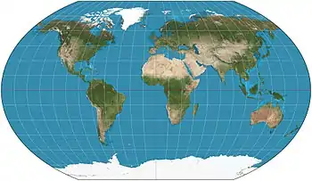
Kavrayskiy VII projection of the Earth
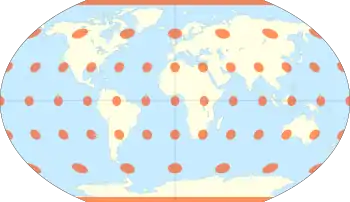
The Kavrayskiy VII projection with Tissot's indicatrix of deformation
The projection is defined as

References
- Snyder, John P. (1993). Flattening the Earth: Two Thousand Years of Map Projections. Chicago: University of Chicago Press. p. 202. ISBN 0-226-76747-7. Retrieved 2014-11-05.
- Goldberg, David M.; Gott III, J. Richard (2007). "Flexion and Skewness in Map Projections of the Earth" (PDF). Cartographica. 42 (4): 297–318. arXiv:astro-ph/0608501. doi:10.3138/carto.42.4.297. Retrieved 2014-11-05.
- Capek, Richard (2001). "Which is the best projection for the world map?". Proceedings of the 20th International Cartographic Conference. Beijing, China. 5: 3084–93. Retrieved 2014-11-05.
External links
| Wikimedia Commons has media related to Maps with Kavrayskiy VII projection. |
- Curvature in Map Projections, quantification of overall distortion in projections.
- Mapthematics Kavrayskiy VII, bivariate distortion map.
- Deducing the Kavrayskiy VII Projection, description of the properties of the Kavrayskiy VII projection.
This article is issued from Wikipedia. The text is licensed under Creative Commons - Attribution - Sharealike. Additional terms may apply for the media files.