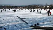
Koseze Pond
Koseze Pond (Slovene: Koseški bajer), Martinek Pond (Martinek bajer) or Lake Koseze (Koseško jezero) is an artificial pond at the edge of Ljubljana, the capital of Slovenia,[1] between Šiška Hill to the west and the neighborhood of Mostec to the east.[2][3] It is part of the Tivoli–Rožnik Hill–Šiška Hill Landscape Park and is named after the nearby Koseze neighborhood in Ljubljana's Šiška District. Near Koseze Pond, the Path of Remembrance and Comradeship touches Tivoli–Rožnik Hill–Šiška Hill Landscape Park.[4]
| Koseze Pond | |
|---|---|
 Koseze Pond | |
 Koseze Pond | |
| Location | Šiška District, City Municipality of Ljubljana, Slovenia |
| Coordinates | 46°4′2.35″N 14°28′7.76″E |
| Type | artificial pond |
| Primary inflows | Mostec Creek |
| Basin countries | Slovenia |
| Surface area | 3.8 ha (9.4 acres) |
| Max. depth | 2–3 m (6 ft 7 in–9 ft 10 in) |
The pond has an area of 3.8 hectares (9.4 acres)[5] and a maximum depth of 2–3 metres (6 ft 7 in–9 ft 10 in).[6] It is fed by Mostec Creek.[7] It was created after a former clay pit[8] at the site, which supplied the brickworks operated by Gustav Tönnies (1814–1886), was closed. The pit was then overgrown by grass, but the Agrostroj company later flooded the area to test irrigation pumps.[9]
Koseze Pond is now used as a recreation area by local residents. In the summer it is used for racing radio-controlled model boats and fishing. Swimming is prohibited due to the poor quality of the water, which is also contaminated by cyanobacteria.[10] In the winter it is used for skating. Koseze Pond is a natural habitat for the edible frog, migrant hawker, common bulrush, and common reed.[11]
See also
- Tivoli Pond, another pond in the Tivoli–Rožnik Hill–Šiška Hill Landscape Park

References
- Struna Bregar, Ana; Kuhar, Špela (17 June 2011). "Koseški bajer, Ljubljana" (PDF). Mladina: Bivanje (in Slovenian) (24).
- "Ljubljanska pot" [Ljubljana Trail]. Vodnik po regionalnih pešpoteh v Ljubljanski urbani regiji [A Guide Through the Regional Trails in the Ljubljana Urban Region] (PDF) (in Slovenian). Regional Development Agency of the Ljubljana Urban Region. August 2010.
- Drobnič, Žiga (2006). "6.4. Primerjava sosesk Savsko naselje (1957) in Mostec (2001)" [6.4. A Comparison of the Sava Settlement (1975) and Mostec (2001) Neighborhoods]. Javne zelene površine v Ljubljani [Public Green Areas in Ljubljana] (PDF) (in Slovenian). Department of Geography, Faculty of Arts, University of Ljubljana. p. 75.
- "Pot spominov in tovarištva - na kratko PST" [The Path of Remembrance and Comradeship (PST)]. Pot spominov in tovarištva [The Path of Remembrance and Comradeship] (PDF) (in Slovenian and English). Ljubljana Tourist Board. April 2006. pp. 10–11.
- Pestotnik, Simona (2011). "Koseški bajer" [Koseze Pond]. Hidrološki model Glinščice s programom Flo-2D: diplomska naloga št. 175 [Hydrological Model of the Glinščica Watershed with the Software Flo-2D: Graduation Thesis No. 175] (PDF). Faculty of Civil and Geodetic Engineering, University of Ljubljana. p. 39.
- Petkovšek, Janez (25 July 2011). "Koseški bajer ogroža zdravje ljudi?" [Koseze Pond Endangers the Health of People?]. Delo.si (in Slovenian).
- Smrekar, Aleš. Bojan Erhartič. Mateja Šmid Hribar (2011). Krajinski park Tivoli, Rožnik in Šišenski hrib [The Tivoli–Rožnik–Šiška Hill Landscape Park]. ZRC Publishing House. p. 56. ISBN 978-961-254-291-7.CS1 maint: uses authors parameter (link)
- Savnik, Roman, ed. 1971. Krajevni leksikon Slovenije, vol. 2. Ljubljana: Državna založba Slovenije. p. 344.
- Gričnik, Anton. 1997. Bela Ljubljana: zgodbe iz slovenske prestolnice. Ljubljana: Kmečki glas, p. 75.
- Koseški bajer ogroža zdravje ljudi? (Koseze Pond a Health Threat?) (in Slovene)
- City Municipality of Ljubljana. 2004. Koseški bajer (sign posted at the pond). Ljubljana: MOL, ZRSVN.
External links
| Wikimedia Commons has media related to Koseze Pond. |
- Ljubljana: 'Koseški bajer' - ribnik [Ljubljana: Koseze Pond]. 2007. VR panorama. Boštjan Burger. (Rich media - may be viewed with QuickTime). Accessed on 19 February 2012.
- Ljubljana: The Green Ring of Ljubljana. The Path of Remembrance and Comradeship at Koseze Pond. 8 May 2009 – 9 May 2009. VR panorama (surround photography). Boštjan Burger. (Rich media - may be viewed with QuickTime). Accessed on 19 February 2012.