Le Pouliguen
Le Pouliguen (French pronunciation: [lə puliɡɛ̃]; Breton: Ar Poulgwenn) is a commune in the Loire-Atlantique department in western France.
Le Pouliguen
Ar Poulgwenn | |
|---|---|
Commune | |
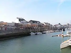 Port and promenade | |
.svg.png.webp) Coat of arms | |
Location of Le Pouliguen 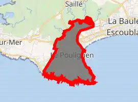
| |
 Le Pouliguen  Le Pouliguen | |
| Coordinates: 47°16′40″N 2°25′45″W | |
| Country | France |
| Region | Pays de la Loire |
| Department | Loire-Atlantique |
| Arrondissement | Saint-Nazaire |
| Canton | La Baule-Escoublac |
| Intercommunality | Cap Atlantique |
| Government | |
| • Mayor (2020–2026) | Norbert Samama |
| Area 1 | 4.39 km2 (1.69 sq mi) |
| Population (2017-01-01)[1] | 4,275 |
| • Density | 970/km2 (2,500/sq mi) |
| Time zone | UTC+01:00 (CET) |
| • Summer (DST) | UTC+02:00 (CEST) |
| INSEE/Postal code | 44135 /44510 |
| Elevation | 0–23 m (0–75 ft) |
| 1 French Land Register data, which excludes lakes, ponds, glaciers > 1 km2 (0.386 sq mi or 247 acres) and river estuaries. | |
Population
| Year | Pop. | ±% |
|---|---|---|
| 1856 | 868 | — |
| 1861 | 921 | +6.1% |
| 1872 | 969 | +5.2% |
| 1881 | 1,182 | +22.0% |
| 1891 | 1,222 | +3.4% |
| 1901 | 1,505 | +23.2% |
| 1911 | 1,690 | +12.3% |
| 1921 | 1,746 | +3.3% |
| 1931 | 2,140 | +22.6% |
| 1946 | 5,148 | +140.6% |
| 1954 | 4,037 | −21.6% |
| 1962 | 3,658 | −9.4% |
| 1968 | 3,788 | +3.6% |
| 1975 | 4,276 | +12.9% |
| 1982 | 4,383 | +2.5% |
| 1990 | 4,912 | +12.1% |
| 1999 | 5,265 | +7.2% |
| 2009 | 4,977 | −5.5% |
| 2017 | 4,275 | −14.1% |
International relations
It is twinned with a town in the Vale of Glamorgan, Wales called Llantwit Major.
References
- "Populations légales 2017". INSEE. Retrieved 6 January 2020.
| Wikimedia Commons has media related to Le Pouliguen. |
This article is issued from Wikipedia. The text is licensed under Creative Commons - Attribution - Sharealike. Additional terms may apply for the media files.