List of cultural property of national significance in Switzerland: Valais
This list contains all cultural property of national significance (class A) in the canton of Valais from the 2009 Swiss Inventory of Cultural Property of National and Regional Significance. It is sorted by municipality and contains 58 individual buildings, 16 collections, 15 archaeological finds and 2 other, special sites or objects.
The geographic coordinates provided are in the Swiss coordinate system as given in the Inventory.
Albinen
| KGS No.? |
Picture | Name | Street Address | CH1903 X coordinate | CH1903 Y coordinate | Location |
|---|---|---|---|---|---|---|
| Unknown | ISOS Dorf: Albinen |
Anniviers
| KGS No.? |
Picture | Name | Street Address | CH1903 X coordinate | CH1903 Y coordinate | Location |
|---|---|---|---|---|---|---|
| 9699 |  Ilôt Bosquet / Chlasche |
 Grimentz | 610.100 | 113.250 | 46.170644°N 7.569413°E |
| Unknown | ISOS village: Ayer | |||||
| Unknown | ISOS village: Grimentz | |||||
| Unknown | ISOS village: Saint-Jean | |||||
| Unknown | ISOS village: Vissoie | |||||
| Unknown | ISOS hameau: Pinsec |
Bellwald
| KGS No.? |
Picture | Name | Street Address | CH1903 X coordinate | CH1903 Y coordinate | Location |
|---|---|---|---|---|---|---|
| Unknown | ISOS Weiler: Bodma |
Bettmeralp
| KGS No.? |
Picture | Name | Street Address | CH1903 X coordinate | CH1903 Y coordinate | Location |
|---|---|---|---|---|---|---|
| Unknown | ISOS Weiler: Eggen |
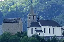
Binn
| KGS No.? |
Picture | Name | Street Address | CH1903 X coordinate | CH1903 Y coordinate | Location |
|---|---|---|---|---|---|---|
| 6629 |  Bogenbrücke (Bridge) with the Chapel of St. Anton |
 Bei der Brücke | 657.358 | 135.005 | 46.363969°N 8.183964°E |
| Unknown | ISOS Dorf: Schmidigehischere | |||||
| Unknown | ISOS Weiler: Fäld |
Bitsch
| KGS No.? |
Picture | Name | Street Address | CH1903 X coordinate | CH1903 Y coordinate | Location |
|---|---|---|---|---|---|---|
| Unknown | ISOS Weiler: Wasen |
Blatten
| KGS No.? |
Picture | Name | Street Address | CH1903 X coordinate | CH1903 Y coordinate | Location |
|---|---|---|---|---|---|---|
| Unknown | ISOS Dorf: Blatten | |||||
| Unknown | ISOS Weiler: Eisten | |||||
| Unknown | ISOS Weiler: Weissenried |
Bourg-Saint-Pierre
| KGS No.? |
Picture | Name | Street Address | CH1903 X coordinate | CH1903 Y coordinate | Location |
|---|---|---|---|---|---|---|
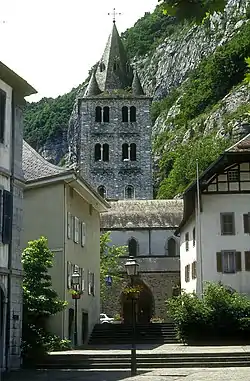
| 6648 | 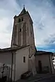 Church of St-Pierre with romanesque Tower |
582.130 | 088.640 | 45.949106°N 7.208191°E | |
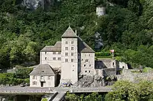
| 6649 |  Hospice with outbuildings library, museum and archives |
Col du Grand Saint-Bernard | 579.196 | 079.752 | 45.869073°N 7.170747°E |
| Unknown | ISOS petite City / bourg: Bourg-Saint-Pierre | |||||
| Unknown | ISOS cas particulier: Grand-Saint-Bernard |
Brig-Glis
| KGS No.? |
Picture | Name | Street Address | CH1903 X coordinate | CH1903 Y coordinate | Location |
|---|---|---|---|---|---|---|
| 6661 | 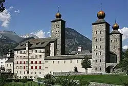 Old and New Stockalperpalast |
 Alte Simplonstrasse 28 | 642.520 | 129.468 | 46.315265°N 7.990656°E |
| 6659 | Gamsenmauer | Talsperre | 639.240 | 128.000 | 46.30226°N 7.947951°E | |
| 6660 | 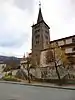 Church of Mariä Himmelfahrt with Ossuary |
 641.550 | 128.950 | 46.310666°N 7.978018°E | |
| Unknown | ISOS Stadt: Brig-Glis |
Bürchen
| KGS No.? |
Picture | Name | Street Address | CH1903 X coordinate | CH1903 Y coordinate | Location |
|---|---|---|---|---|---|---|
| Unknown | ISOS Spezialfall:Turtig/Wandfluh shared between Bürchen, Raron, Unterbäch |
Chamoson
| KGS No.? |
Picture | Name | Street Address | CH1903 X coordinate | CH1903 Y coordinate | Location |
|---|---|---|---|---|---|---|
| 6682 |  Church of St-Pierre and Priory |
 Rue De L’Eglise | 584.460 | 115.650 | 46.19213°N 7.237345°E |
| Unknown | ISOS village: Saint-Pierre de Clages |
Conthey
| KGS No.? |
Picture | Name | Street Address | CH1903 X coordinate | CH1903 Y coordinate | Location |
|---|---|---|---|---|---|---|
| Unknown | ISOS cas particulier: Conthey-Bourg / Saint-Séverin |
Crans-Montana
| KGS No.? |
Picture | Name | Street Address | CH1903 X coordinate | CH1903 Y coordinate | Location |
|---|---|---|---|---|---|---|
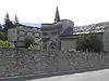
| 6853 |  Fairy Rock Castle (Roches Des Fées) |
 606.280 | 130.460 | 46.325505°N 7.520183°E | |
| 10361 | Hotel Bella Lui | Montana-Station 21 | 602.862 | 128.976 | 46.312178°N 7.475791°E |
Eischoll
| KGS No.? |
Picture | Name | Street Address | CH1903 X coordinate | CH1903 Y coordinate | Location |
|---|---|---|---|---|---|---|
| Unknown | ISOS Dorf: Eischoll |
Eisten
| KGS No.? |
Picture | Name | Street Address | CH1903 X coordinate | CH1903 Y coordinate | Location |
|---|---|---|---|---|---|---|
| Unknown | ISOS Village: Eisten |
Ernen
| KGS No.? |
Picture | Name | Street Address | CH1903 X coordinate | CH1903 Y coordinate | Location |
|---|---|---|---|---|---|---|
| 6709 | 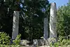 Erner Galgen |
 654.500 | 139.360 | 46.403382°N 8.14734°E | |
| 10356 | Jost-Sigristen House | Dorf | 654.406 | 138.807 | 46.398415°N 8.146053°E | |
| 6715 |  Tellen House |
 Dorf | 654.390 | 138.870 | 46.398983°N 8.145852°E |
| Unknown | ISOS Village: Ernen | |||||
| Unknown | ISOS Village: Mühlebach |
Evionnaz
| KGS No.? |
Picture | Name | Street Address | CH1903 X coordinate | CH1903 Y coordinate | Location |
|---|---|---|---|---|---|---|
| Unknown | ISOS village: Evionnaz |
Evolène
| KGS No.? |
Picture | Name | Street Address | CH1903 X coordinate | CH1903 Y coordinate | Location |
|---|---|---|---|---|---|---|
| 9698 | 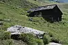 Alpage De Cotter Prehistoric Rock Carvings |
606.200 | 107.320 | 46.117348°N 7.518837°E | |
| 10358 |  Maison d’habitation |
 Les Haudères | 604.000 | 106.000 | 46.105491°N 7.490368°E |
| Unknown | ISOS village: Evolène | |||||
| Unknown | ISOS village: Les Haudères | |||||
| Unknown | ISOS hameau: Lana |
Ferden
| KGS No.? |
Picture | Name | Street Address | CH1903 X coordinate | CH1903 Y coordinate | Location |
|---|---|---|---|---|---|---|
| 10360 | Rotigostadel | 624.600 | 138.070 | 46.39354°N 7.758467°E |
Finhaut
| KGS No.? |
Picture | Name | Street Address | CH1903 X coordinate | CH1903 Y coordinate | Location |
|---|---|---|---|---|---|---|
| Unknown | ISOS cas particulier: Finhaut |
Fully
| KGS No.? |
Picture | Name | Street Address | CH1903 X coordinate | CH1903 Y coordinate | Location |
|---|---|---|---|---|---|---|
| Unknown | ISOS hameau: Branson |
Goms
| KGS No.? |
Picture | Name | Street Address | CH1903 X coordinate | CH1903 Y coordinate | Location |
|---|---|---|---|---|---|---|
| 6878 | 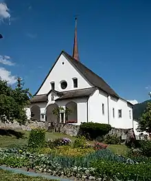 Church of St. Maria with Cemetery Chapel |
Münster-Geschinen | 663.480 | 148.750 | 46.487056°N 8.265391°E |
| 6948 | 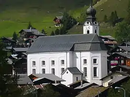 Church of Mariä Geburt |
 Furkastrasse, Reckingen-Gluringen | 661.738 | 146.781 | 46.469508°N 8.242443°E |
| Unknown | ISOS Dorf: Niederwald | |||||
| Unknown | ISOS Dorf: Gluringen | |||||
| Unknown | ISOS Dorf: Reckingen | |||||
| Unknown | ISOS Dorf: Biel | |||||
| Unknown | ISOS Dorf: Ritzingen | |||||
| Unknown | ISOS Dorf: Selkingen | |||||
| Unknown | ISOS Dorf: Geschinen | |||||
| Unknown | ISOS Dorf: Münster | |||||
| Unknown | ISOS Weiler: Ammere / Gadme /Wiler | |||||
| Unknown | ISOS Weiler: Bodmen |
Grengiols
| KGS No.? |
Picture | Name | Street Address | CH1903 X coordinate | CH1903 Y coordinate | Location |
|---|---|---|---|---|---|---|
| Unknown | ISOS Dorf: Grengiols |
Guttet-Feschel
| KGS No.? |
Picture | Name | Street Address | CH1903 X coordinate | CH1903 Y coordinate | Location |
|---|---|---|---|---|---|---|
| Unknown | ISOS Dorf: Feschel |
Hérémence
| KGS No.? |
Picture | Name | Street Address | CH1903 X coordinate | CH1903 Y coordinate | Location |
|---|---|---|---|---|---|---|
| 10521 |  Catholic Church |
 597.361 | 114.329 | 46.180421°N 7.404461°E | |
| 6775 | 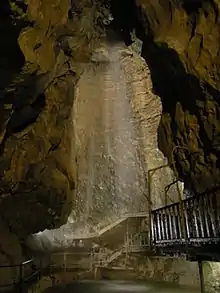 aux Fées Cave |
 596.000 | 109.830 | 46.139943°N 7.386874°E | |
| 9047 |  La Grande Dixence Dam |
 597.255 | 103.230 | 46.08058°N 7.403153°E | |
| Unknown | ISOS village: Hérémence | |||||
| Unknown | ISOS hameau: Mâche / Mâchette |
Isérables
| KGS No.? |
Picture | Name | Street Address | CH1903 X coordinate | CH1903 Y coordinate | Location |
|---|---|---|---|---|---|---|
| Unknown | ISOS village: Isérables |
Kippel
| KGS No.? |
Picture | Name | Street Address | CH1903 X coordinate | CH1903 Y coordinate | Location |
|---|---|---|---|---|---|---|
| Unknown | ISOS Dorf: Kippel |
Lens
| KGS No.? |
Picture | Name | Street Address | CH1903 X coordinate | CH1903 Y coordinate | Location |
|---|---|---|---|---|---|---|
| Unknown | ISOS village: Lens |
Leuk
| KGS No.? |
Picture | Name | Street Address | CH1903 X coordinate | CH1903 Y coordinate | Location |
|---|---|---|---|---|---|---|
| 6808 |  Dalaturm |
 614.182 | 129.490 | 46.316659°N 7.62276°E | |
| 6801 |  Church of St. Stephan |
 Hauptplatz 16 | 615.125 | 129.564 | 46.317304°N 7.635005°E |
| 6802 |  Rathaus (Town council house) |
 Rathausplatz 1 | 615.113 | 129.434 | 46.316135°N 7.634845°E |
| 6803 |  Ringacker Chapel of Mariä Empfängnis with Hermitage |
615.150 | 129.190 | 46.313939°N 7.635317°E | |
| 6804 |  Zen-Ruffinen Castle / Loretan |
 615.037 | 129.440 | 46.31619°N 7.633858°E | |
| Unknown | ISOS Kleinstadt / Flecken: Leuk | |||||
| Unknown | ISOS Village: Erschmatt |
Leukerbad
| KGS No.? |
Picture | Name | Street Address | CH1903 X coordinate | CH1903 Y coordinate | Location |
|---|---|---|---|---|---|---|
| 6820 | 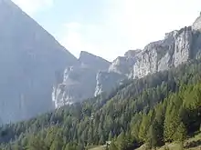 Gemmi Daubenwand |
 613.680 | 138.041 | 46.39359°N 7.616494°E |
Liddes
| KGS No.? |
Picture | Name | Street Address | CH1903 X coordinate | CH1903 Y coordinate | Location |
|---|---|---|---|---|---|---|
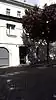
| 6825 | .jpg.webp) Les Moulins |
Les Moulins | 579.037 | 094.794 | 46.004375°N 7.168032°E | |
| Unknown | ISOS village: Liddes |
Martigny
| KGS No.? |
Picture | Name | Street Address | CH1903 X coordinate | CH1903 Y coordinate | Location |
|---|---|---|---|---|---|---|
| 6831 |  Centre valaisan du film |
 Avenue du Grand-St-Bernard 4 | 571.618 | 105.511 | 46.100507°N 7.071616°E |
| 6832 | La Bâtiaz Castle | 571.440 | 106.020 | 46.105078°N 7.069284°E | ||
| 9384 |  |
Gallo-Roman Museum, Automobile Museum, Fondation Pierre Gianadda |
571.549 | 104.914 | 46.095134°N 7.07076°E | |
| 9700 |  City, Roman era and Modern City |
571.800 | 105.300 | 46.098616°N 7.073983°E | |
| Unknown | ISOS ville: Martigny-Ville | |||||
| Unknown | ISOS petite City / bourg: Martigny-Bourg |

Martigny-Combe
| KGS No.? |
Picture | Name | Street Address | CH1903 X coordinate | CH1903 Y coordinate | Location |
|---|---|---|---|---|---|---|
| Unknown | ISOS cas particulier: Plan Cerisier |
Massongex
| KGS No.? |
Picture | Name | Street Address | CH1903 X coordinate | CH1903 Y coordinate | Location |
|---|---|---|---|---|---|---|
| 9701 | 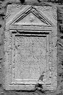 |
Tarnaiae, Celtic - Gallo Roman Vicus |
565.320 | 121.375 | 46.242915°N 6.989001°E |
Mont-Noble
| KGS No.? |
Picture | Name | Street Address | CH1903 X coordinate | CH1903 Y coordinate | Location |
|---|---|---|---|---|---|---|
| Unknown | ISOS village: Mase |
Naters
| KGS No.? |
Picture | Name | Street Address | CH1903 X coordinate | CH1903 Y coordinate | Location |
|---|---|---|---|---|---|---|
| 6888 | Ossuary | Beinhausweg | 642.320 | 130.600 | 46.325461°N 7.988163°E | |
| 6887 |  Church of St. Mauritius |
 642.300 | 130.615 | 46.325597°N 7.987905°E | |
| Unknown | ISOS Urbanized Village: Naters | |||||
| Unknown | ISOS Village: Blatten | |||||
| Unknown | ISOS Hamlet: Bodmen |

Niedergesteln
| KGS No.? |
Picture | Name | Street Address | CH1903 X coordinate | CH1903 Y coordinate | Location |
|---|---|---|---|---|---|---|
| 6903 | 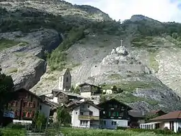 Gestelnburg |
 626.540 | 129.150 | 46.313226°N 7.78318°E | |
| Unknown | ISOS Dorf: Niedergesteln |
Noble-Contrée
| KGS No.? |
Picture | Name | Street Address | CH1903 X coordinate | CH1903 Y coordinate | Location |
|---|---|---|---|---|---|---|
| 7163 | Tower | 607.199 | 128.480 | 46.307684°N 7.532085°E | ||
| Unknown | ISOS village: Venthône |
Obergoms
| KGS No.? |
Picture | Name | Street Address | CH1903 X coordinate | CH1903 Y coordinate | Location |
|---|---|---|---|---|---|---|
| Unknown | ISOS Dorf: Obergesteln | |||||
| Unknown | ISOS Dorf: Ulrichen | |||||
| Unknown | ISOS Spezialfall: Gletsch |
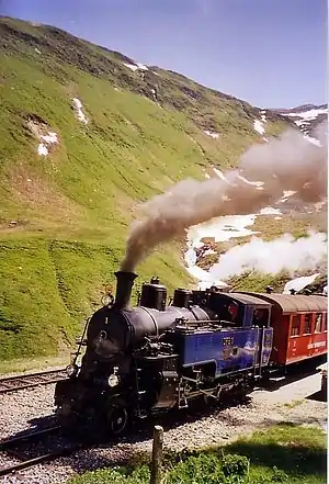
Oberwald
| KGS No.? |
Picture | Name | Street Address | CH1903 X coordinate | CH1903 Y coordinate | Location |
|---|---|---|---|---|---|---|
| 10362 | Furkabahn Cog-Wheel Railway |
669.000 | 154.000 | 46.533734°N 8.33806°E |
Orsières
| KGS No.? |
Picture | Name | Street Address | CH1903 X coordinate | CH1903 Y coordinate | Location |
|---|---|---|---|---|---|---|
| 10447 | 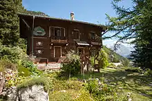 Botanical Gardens of Alpin Flore-Alpe |
 Champex | 574.109 | 098.241 | 46.035211°N 7.104229°E |
| Unknown | ISOS hameau: Commeire |
Raron
| KGS No.? |
Picture | Name | Street Address | CH1903 X coordinate | CH1903 Y coordinate | Location |
|---|---|---|---|---|---|---|
| 6940 | Heidnischbühl, Prehistoric Site |
628.600 | 128.800 | 46.309993°N 7.809901°E | ||
| 6936 | 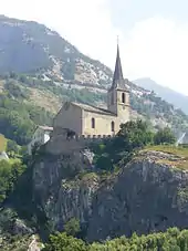 Church of St. Roman with old Rectory |
Burghügel | 628.085 | 128.872 | 46.310662°N 7.80322°E |
| 6939 |  Wohnturm der Viztume |
 628.126 | 128.895 | 46.310867°N 7.803754°E | |
| Unknown | ISOS Dorf: Raron | |||||
| Unknown | ISOS Weiler: Rarner Chumma | |||||
| Unknown | ISOS Spezialfall:Turtig/Wandfluh shared with Bürchen, Raron and Unterbäch |
Riederalp
| KGS No.? |
Picture | Name | Street Address | CH1903 X coordinate | CH1903 Y coordinate | Location |
|---|---|---|---|---|---|---|
| Unknown | ISOS Dorf: Goppisberg | |||||
| Unknown | ISOS Dorf: Greich |
Saas-Balen
| KGS No.? |
Picture | Name | Street Address | CH1903 X coordinate | CH1903 Y coordinate | Location |
|---|---|---|---|---|---|---|
| 6967 | 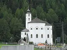 Church of Mariä Himmelfahrt |
 637.711 | 111.452 | 46.153491°N 7.92677°E | |
| Unknown | ISOS Weiler: Bidermatten |
Saillon
| KGS No.? |
Picture | Name | Street Address | CH1903 X coordinate | CH1903 Y coordinate | Location |
|---|---|---|---|---|---|---|
| 10448 |  Fortifications |
 580.392 | 113.356 | 46.171388°N 7.184748°E | |
| 6975 |  Bayard Tower |
 580.230 | 113.260 | 46.17052°N 7.182654°E | |
| Unknown | ISOS petite city / bourg: Saillon |
Saint-Gingolph
| KGS No.? |
Picture | Name | Street Address | CH1903 X coordinate | CH1903 Y coordinate | Location |
|---|---|---|---|---|---|---|
| Unknown | ISOS cas particulier: Saint-Gingolph |
Saint-Léonard
| KGS No.? |
Picture | Name | Street Address | CH1903 X coordinate | CH1903 Y coordinate | Location |
|---|---|---|---|---|---|---|
| 9702 | Crête Des Barmes, gravures rupestres néolithiques |
598.850 | 123.700 | 46.264723°N 7.423721°E |
Saint-Luc
| KGS No.? |
Picture | Name | Street Address | CH1903 X coordinate | CH1903 Y coordinate | Location |
|---|---|---|---|---|---|---|
| 7106 |  Groupe Des 5 Moulins |
 612.840 | 118.360 | 46.216565°N 7.60503°E |
Saint-Maurice
| KGS No.? |
Picture | Name | Street Address | CH1903 X coordinate | CH1903 Y coordinate | Location |
|---|---|---|---|---|---|---|
| 7114 8825 8669 9703 |
 |
St-Maurice D’Agaune Abbey, Foundation of Historical Archives, Archeological Discoveries of the Abbey |
566.420 | 118.750 | 46.219358°N 7.003451°E | |
| 7117 8710 |
 Castle, Cantonal Military Museum |
Route du Chablais | 566.396 | 119.184 | 46.223261°N 7.003109°E |
| 7118 |  Maison de la Pierre |
 Grand-Rue 54 | 566.527 | 118.750 | 46.219364°N 7.004838°E |
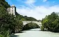
| 10365 | Bridge over the Rhône, shared with Bex, Vaud |
Route du Chablais / Route de Saint-Maurice | 566.421 | 119.207 | 46.223469°N 7.003431°E | |
| Unknown | ISOS petite City / bourg: Saint-Maurice |
Salvan
| KGS No.? |
Picture | Name | Street Address | CH1903 X coordinate | CH1903 Y coordinate | Location |
|---|---|---|---|---|---|---|
| 6980 | .JPG.webp) Les Marécottes, A Storage Basin for the Swiss Federal Railways |
Les Marécottes, A Storage Basin for the Swiss Federal Railways |
566.500 | 106.500 | 46.109169°N 7.005364°E | |
| Unknown | ISOS hameau: Le Trétien |
Sembrancher
| KGS No.? |
Picture | Name | Street Address | CH1903 X coordinate | CH1903 Y coordinate | Location |
|---|---|---|---|---|---|---|
| Unknown | ISOS petite City / bourg: Sembrancher |
Sierre
| KGS No.? |
Picture | Name | Street Address | CH1903 X coordinate | CH1903 Y coordinate | Location |
|---|---|---|---|---|---|---|
| 7007 | 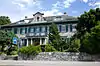 Centrale Électrique and Bâtiments Alusuisse |
 Chippis | 607.850 | 125.770 | 46.283299°N 7.54049°E |
| Unknown | ISOS cas particulier: Sierre |
Simplon
| KGS No.? |
Picture | Name | Street Address | CH1903 X coordinate | CH1903 Y coordinate | Location |
|---|---|---|---|---|---|---|
| 7030 |  Old Hospiz |
 644.495 | 120.575 | 46.235142°N 8.015448°E | |
| Unknown | ISOS Dorf: Simplon Village | |||||
| Unknown | ISOS Weiler: Eggen | |||||
| Unknown | ISOS Spezialfall: Simplon Pass |
Sion
| KGS No.? |
Picture | Name | Street Address | CH1903 X coordinate | CH1903 Y coordinate | Location |
|---|---|---|---|---|---|---|
| 8823 | Archives De L’Etat Du Valais | Rue Des Vergers 7 | 593.822 | 120.028 | 46.231664°N 7.358555°E | |
| 8723 8904 8903 |
 Archives and Museum de l’Evêché de Sion et Archives du vénérable Chapitre cathédral de Sion |
Rue de la Tour 12 | 593.801 | 120.258 | 46.233732°N 7.358279°E |
| 7035 |  Notre-Dame Cathedral |
 593.875 | 120.286 | 46.233985°N 7.359238°E | |
| 7058 9349 |
 Couvent des Capucins and Library |
 593.840 | 120.700 | 46.237709°N 7.358779°E | |
| 7037 | Church and Castle Notre-Dame de Valère | Ruelle de Tous-Vents 15 | 594.267 | 120.249 | 46.233656°N 7.36432°E | |
| 7038 |  Church of St-Théodule |
 593.858 | 120.236 | 46.233535°N 7.359018°E | |
| 7040 |  Hôtel de Ville (City Hall) |
 Rue du Grand-Pont 12 | 593.985 | 120.263 | 46.233779°N 7.360664°E |
| 7041 | La Majorie Castle | Rue des châteaux 19 | 594.083 | 120.338 | 46.234455°N 7.361934°E | |
| 10367 |  Le Vidomnat |
 Place de la Majorie15 | 594.033 | 120.327 | 46.234355°N 7.361286°E |
| 7042 |  Maison Supersaxo |
 Rue Supersaxo 4 | 593.928 | 120.208 | 46.233284°N 7.359926°E |
| 9316 | 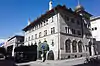 Médiathèque Valais Sion |
 Rue des Vergers 9 | 593.822 | 120.028 | 46.231664°N 7.358555°E |
| 8721 8722 |
 Cantonal Museum of Fine Arts and History Museum |
 594.075 | 120.311 | 46.234212°N 7.361831°E | |
| 7044 | .JPG.webp) Ruins of Tourbillon Castle |
Ruins of Tourbillon Castle | 594.470 | 120.560 | 46.236455°N 7.366948°E | |
| 9704 |  Old City, Neolithic and Modern City |
593.600 | 119.800 | 46.229611°N 7.35568°E | |
| Unknown | ISOS ville: Sion | |||||
| Unknown | ISOS village: Bramois |


Stalden
| KGS No.? |
Picture | Name | Street Address | CH1903 X coordinate | CH1903 Y coordinate | Location |
|---|---|---|---|---|---|---|
| 7086 | 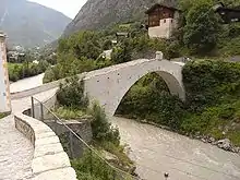 Kinbrücke (bridge) over the Mattervispa with a Wayside shrine |
633.370 | 119.880 | 46.229533°N 7.871183°E | |
| Unknown | ISOS Dorf: Stalden (VS) | |||||
| Unknown | ISOS Spezialfall: Neubrück |
Törbel
| KGS No.? |
Picture | Name | Street Address | CH1903 X coordinate | CH1903 Y coordinate | Location |
|---|---|---|---|---|---|---|
| 7134 |  Mill |
 Walke | 631.175 | 120.940 | 46.239174°N 7.842802°E |
| Unknown | ISOS Dorf: Törbel | |||||
| Unknown | ISOS Weiler: Burge | |||||
| Unknown | ISOS Weiler: Feld |
Turtmann
| KGS No.? |
Picture | Name | Street Address | CH1903 X coordinate | CH1903 Y coordinate | Location |
|---|---|---|---|---|---|---|
| Unknown | ISOS Dorf: Turtmann |
Unterbäch
| KGS No.? |
Picture | Name | Street Address | CH1903 X coordinate | CH1903 Y coordinate | Location |
|---|---|---|---|---|---|---|
| Unknown | ISOS Spezialfall:Turtig/Wandfluh shared with Bürchen, Raron, Unterbäch |
Val-d'Illiez
| KGS No.? |
Picture | Name | Street Address | CH1903 X coordinate | CH1903 Y coordinate | Location |
|---|---|---|---|---|---|---|
| 10368 |  Maison D’Habitation |
 Plat | 557.560 | 116.364 | 46.197395°N 6.888848°E |
Val de Bagnes
| KGS No.? |
Picture | Name | Street Address | CH1903 X coordinate | CH1903 Y coordinate | Location |
|---|---|---|---|---|---|---|
| 6604 |  Alpage De Louvie |
 Mauvoisin | 589.920 | 100.060 | 46.051994°N 7.308404°E |
| 6603 | Church of St-Maurice, Ossuary and Former Rectory |
Le Châble | 582.230 | 103.240 | 46.080441°N 7.20893°E | |
| Unknown | ISOS village: Bruson | |||||
| Unknown | ISOS village: Le Châble | |||||
| Unknown | ISOS village: Médières | |||||
| Unknown | ISOS village: Sarreyer | |||||
| Unknown | ISOS hameau: Fontenelle | |||||
| Unknown | ISOS village: Vollèges | |||||
| Unknown | ISOS hameau: Vens |
Vernayaz
| KGS No.? |
Picture | Name | Street Address | CH1903 X coordinate | CH1903 Y coordinate | Location |
|---|---|---|---|---|---|---|
| Unknown | ISOS hameau: Miéville |
Vionnaz
| KGS No.? |
Picture | Name | Street Address | CH1903 X coordinate | CH1903 Y coordinate | Location |
|---|---|---|---|---|---|---|
| Unknown | ISOS village: Vionnaz |
Visp
| KGS No.? |
Picture | Name | Street Address | CH1903 X coordinate | CH1903 Y coordinate | Location |
|---|---|---|---|---|---|---|
| Unknown | ISOS Kleinstadt / Flecken: Visp |
Visperterminen
| KGS No.? |
Picture | Name | Street Address | CH1903 X coordinate | CH1903 Y coordinate | Location |
|---|---|---|---|---|---|---|
| 9705 | Oberstalden, Bronze Age / Medieval Settlement |
635.200 | 124.600 | 46.271899°N 7.895259°E | ||
| Unknown | ISOS Weiler: Barmüli | |||||
| Unknown | ISOS Weiler: Bitzinen | |||||
| Unknown | ISOS Weiler: Niederhäusern | |||||
| Unknown | ISOS Weiler: Oberstalden | |||||
| Unknown | ISOS Weiler: Unterstalden |
Vouvry
| KGS No.? |
Picture | Name | Street Address | CH1903 X coordinate | CH1903 Y coordinate | Location |
|---|---|---|---|---|---|---|
| Unknown | ISOS village: Vouvry |
Zermatt
| KGS No.? |
Picture | Name | Street Address | CH1903 X coordinate | CH1903 Y coordinate | Location |
|---|---|---|---|---|---|---|
| 9706 | Hubelwäng, Petroglyphs / Prehistoric Grinding Stones |
Felszeichnungen / prähistorische | 622.500 | 095.600 | 46.011575°N 7.729122°E |
Zwischbergen
| KGS No.? |
Picture | Name | Street Address | CH1903 X coordinate | CH1903 Y coordinate | Location |
|---|---|---|---|---|---|---|
| 7229 | Ruins of the Gold Mine at Gondo | 654.150 | 115.400 | 46.187884°N 8.140004°E |
References
- All entries, addresses and coordinates are from: "Kantonsliste A-Objekte". KGS Inventar (in German). Federal Office of Civil Protection. 2009. Archived from the original on 28 June 2010. Retrieved 25 April 2011.
External links
- Swiss Inventory of Cultural Property of National and Regional Significance, 2009 edition:
- "Revision of the PCP Inventory (Revision des KGS-Inventars)". KGS Forum. Federal Office of Civil Protection (13/2008). 2008. Archived from the original on 5 May 2011. Retrieved 25 April 2011.
This article is issued from Wikipedia. The text is licensed under Creative Commons - Attribution - Sharealike. Additional terms may apply for the media files.