List of peaks in Rocky Mountain National Park
The list of peaks in Rocky Mountain National Park includes the following:[1]
| Trailhead | Image | Peak | Height | Location |
|---|---|---|---|---|
| Bear Lake | 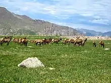 | Flattop Mountain | 12,326 ft / 3,757 m | 40.309°N 105.690°W[2] |
| Bear Lake | .jpg.webp) | Hallett Peak | 12,598 ft / 3,840 m | 40.303°N 105.686°W[3] |
| Bear Lake | Hayden Spire | 12,421 ft / 3,786 m | 40.351°N 105.740°W[4] | |
| Bear Lake | Knobtop Mountain | 12,336 ft / 3,760 m | 40.324°N 105.701°W[5] | |
| Bear Lake | 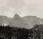 | Little Matterhorn | 11,532 ft / 3,515 m | 40.327°N 105.692°W[6] |
| Bear Lake | Notchtop Mountain | 11,929/ ft / 3,636 m | 40.318°N 105.694°W[7] | |
| Bear Lake | Ptarmigan Point | 12,270 ft / 3,740 m | 40.313°N 105.701°W[8] | |
| Bear Lake | Snowdrift Peak | 12,205 ft / 3,720 m | 40.310°N 105.743°W[9] | |
| Chapin Pass | Desolation Peaks | 12,674 ft / 3,863 m | 40.472°N 105.693°W[10] | |
| Chapin Pass | Mount Chapin | 12,438 ft / 3,791 m | 40.433°N 105.701°W[11] | |
| Chapin Pass | 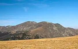 | Mount Chiquita (center) | 13,051 ft / 3,978 m | 40.443°N 105.688°W[12] |
| Chapin Pass | 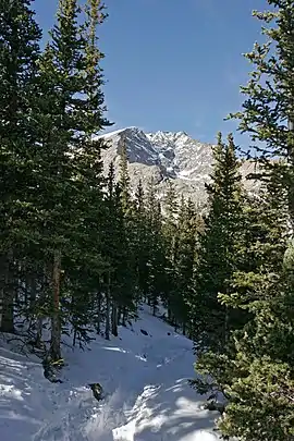 | Ypsilon Mountain | 13,445 ft / 4,098 m | 40.456°N 105.681°W[13] |
| Colorado River | Howard Mountain | 12,762 ft / 3,890 m | 40.426°N 105.898°W[14] | |
| Colorado River | _July_2016.jpg.webp) | Lead Mountain | 12,474 ft / 3,802 m | 40.448°N 105.897°W[15] |
| Colorado River | Lulu Mountain | 12,201 ft / 3,719 m | 40.479°N 105.862°W[16] | |
| Colorado River | Mount Cirrus | 12,730 ft / 3,880 m | 40.434°N 105.901°W[17] | |
| Colorado River | Mount Cumulus | 12,733 ft / 3,881 m | 40.410°N 105.902°W[18] | |
| Colorado River | Mount Nimbus | 12,644 ft / 3,854 m | 40.396°N 105.904°W[19] | |
| Cow Creek | Dark Mountain | 10,827 ft / 3,300 m | 40.432°N 105.5719°W[20] | |
| Emmaline Lake | Comanche Peak | 12,690 ft / 3,868 m | 40.548°N 105.677°W[21] | |
| Emmaline Lake | Fall Mountain | 12,257 ft / 3,736 m | 40.528°N 105.661°W[22] | |
| Fern Lake | Stones Peak | 12,894 ft / 3,930 m | 40.354°N 105.721°W[23] | |
| Glacier Gorge | Arrowhead | 12,651 ft / 3,856 m | 40.268°N 105.650°W[24] | |
| Glacier Gorge | Chiefs Head Peak | 13,579 ft / 4,121 m | 40.249°N 105.641°W[25] | |
| Glacier Gorge | Half Mountain | 11,437 ft / 3,486 m | 40.290°N 105.633°W[26] | |
| Glacier Gorge | McHenrys Peak | 13,327 ft / 4,062 m | 40.263°N 105.658°W[27] | |
| Glacier Gorge | Otis Peak | 12,444 ft / 3,793 | 40.292°N 105.680°W[28] | |
| Glacier Gorge | Pagoda Mountain | 13,392 ft / 4,082 m | 40.251°N 105.626°W[29] | |
| Glacier Gorge |  | Petit Grepon | 12,000 ft / 3,658 m | 40.280°N 105.673°W[30] |
| Glacier Gorge |  | Powell Peak | 13,149 ft / 4,008 m | 40.2658°N 105.6647°W[31] |
| Glacier Gorge | The Sharkstooth | 12,411 ft / 3,783 m | 40.280°N 105.674°W[32] | |
| Glacier Gorge | The Spearhead | 12,533 ft / 3,820 m | 40.255°N 105.638°W[33] | |
| Glacier Gorge | 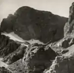 | Taylor Peak | 13,117 ft / 3,998 m | 40.274°N 105.680°W[34] |
| Glacier Gorge | Thatchtop | 12,657 ft / 3,858 m | 40.279°N 105.653°W[35] | |
| Green Mountain | Nakai Peak | 11,916 ft / 3,632 m | 40.346°N 105.776°W[36] | |
| Green Mountain | Sprague Mountain | 12,697 ft / 3,870 m | 40.347°N 105.736°W[37] | |
| Lake Agnes | 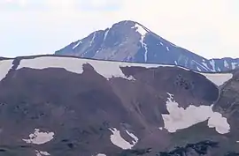 | Mount Richthofen | 12,890 ft / 3,929 m | 40.469°N 105.895°W[38] |
| Lake Agnes | _July_2016.jpg.webp) | Static Peak | 12,575 ft / 3,833 m | 40.477°N 105.892°W[39] |
| Lake Agnes | Tepee Mountain | 12,306 ft / 3,751 m | 40.463°N 105.899°W[40] | |
| Lawn Lake |  | Fairchild Mountain | 13,508 ft / 4,116 m | 40.468°N 105.664°W[41] |
| Lawn Lake | 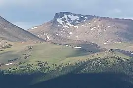 | Hagues Peak | 13,570 ft / 4,096 m | 40.485°N 105.646°W[42] |
| Lawn Lake | 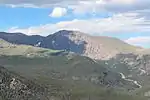 | Mummy Mountain | 13,382 ft / 4,079 m | 40.476°N 105.626°W[43] |
| Lawn Lake | Rowe Peak | 13,399 ft / 4,084 m | 40.490°N 105.645°W[44] | |
| Longs Peak | Estes Cone | 11,010 ft / 3,356 m | 40.295°N 105.567°W[45] | |
| Longs Peak | 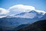 | Longs Peak | 14,258 ft / 4,346 m | 40.255°N 105.616°W[46] |
| Longs Peak | Mount Lady Washington | 13,245 ft / 4,037 m | 40.263°N 105.607°W[47] | |
| Longs Peak |  | Mount Meeker (left) | 13,868 ft / 4,227 m | 40.249°N 105.605°W[48] |
| Longs Peak | Storm Peak | 13,320 ft / 4,060 m | 40.266°N 105.6205°W[49] | |
| Lumpy Ridge | Lumpy Ridge / The Needles | 10,059 ft / 3,066 m | 40.416°N 105.551°W[50] | |
| Meeker Park | Horsetooth Peak | 10,341 ft / 3,152 m | 40.232°N 105.560°W[51] | |
| Meeker Park | Lookout Mountain | 10,702 ft / 3,262 m | 40.227°N 105.565°W[52] | |
| Milner Pass | Chief Cheley Peak | 12,815 ft / 3,906 m | 40.367°N 105.774°W[53] | |
| Milner Pass | Cracktop | 12,762 ft / 3,890 m | 40.366°N 105.766°W[54] | |
| Milner Pass |  | Mount Ida | 12,844 ft / 3,915 m | 40.372°N 105.779°W[55] |
| Milner Pass | _viewed_from_Trail_Ridge_Road.jpg.webp) | Mount Julian | 12,920 ft / 3,938 m | 40.371°N 105.758°W[56] |
| Milner Pass | Terra Tomah Mountain | 12,693 ft / 3,869 m | 40.3763°N 105.750°W[57] | |
| Saint Vrain Mountain | Meadow Mountain | 11,634 ft / 3,546 m | 40.175°N 105.570°W[58] | |
| Saint Vrain Mountain | Saint Vrain Mountain | 12,149 ft / 3,703 m | 40.161°N 105.585°W[59] | |
| Stormy Peaks | Stormy Peaks | 12,113 ft / 3,692 m | 40.520°N 105.587°W[60] | |
| Trail Ridge Road |  | Sundance Mountain | 12,447 ft / 3,794 m | 40.408°N 105.711°W[61] |
| Twin Sisters |  | Twin Sisters Peaks | 11,332 ft / 3,454 m | 40.289°N 105.518°W[62] |
| Wild Basin | Copeland Mountain | 13,166 ft / 4,013 m | 40.182°N 105.646°W[63] | |
| Wild Basin | Elk Tooth | 12,848 ft / 3,916 m | 40.168°N 105.654°W[64] | |
| Wild Basin | Isolation Peak | 13,067 ft / 3,983 m | 40.203°N 105.677°W[65] | |
| Wild Basin | Mount Alice | 13,281 ft / 4,048 m | 40.239°N 105.663°W[66] | |
| Wild Basin | Ogalalla Peak | 13,081 ft / 3,987 m | 40.170°N 105.667°W[67] | |
| Wild Basin | Ouzel Peak | 12,677 ft / 3,864 m | 40.186°N 105.671°W[68] | |
| Wild Basin | Pilot Mountain | 12,113 ft / 3,692 m | 40.231°N 105.658°W[69] | |
| Wild Basin | The Cleaver | 12,178 / 3,712 | 40.217°N 105.671°W [70] | |
| Map |
|---|
| Create a map of all Rocky Mountain National Park peak coordinates using this OpenStreetMap (OSM) link |
References
- "Rocky Mountain National Park - Trailheads and Peaks". Summit Post. Retrieved October 31, 2016.
- "Flattop Mountain". Geographic Names Information System. United States Geological Survey. October 13, 1978. Retrieved November 1, 2016.
- "Hallett Peak". Geographic Names Information System. United States Geological Survey. October 13, 1978. Retrieved November 1, 2016.
- "Hayden Spire". Geographic Names Information System. United States Geological Survey. October 13, 1978. Retrieved November 1, 2016.
- "Knobtop Mountain". Geographic Names Information System. United States Geological Survey. October 13, 1978. Retrieved November 1, 2016.
- "Little Matterhorn". Geographic Names Information System. United States Geological Survey. October 13, 1978. Retrieved November 1, 2016.
- "Notchtop Mountain". Geographic Names Information System. United States Geological Survey. October 13, 1978. Retrieved November 1, 2016.
- "Ptarmigan Point". Geographic Names Information System. United States Geological Survey. October 13, 1978. Retrieved November 1, 2016.
- "Snowdrift Peak". Geographic Names Information System. United States Geological Survey. October 13, 1978. Retrieved November 1, 2016.
- "Desolation Peaks". Geographic Names Information System. United States Geological Survey. October 13, 1978. Retrieved November 1, 2016.
- "Mount Chapin". Geographic Names Information System. United States Geological Survey. October 13, 1978. Retrieved November 1, 2016.
- "Mount Chiquita". Geographic Names Information System. United States Geological Survey. October 13, 1978. Retrieved November 1, 2016.
- "Ypsilon Mountain". Geographic Names Information System. United States Geological Survey. October 13, 1978. Retrieved November 1, 2016.
- "Howard Mountain". Geographic Names Information System. United States Geological Survey. October 13, 1978. Retrieved November 1, 2016.
- "Lead Mountain". Geographic Names Information System. United States Geological Survey. October 13, 1978. Retrieved November 1, 2016.
- "Lulu Mountain". Geographic Names Information System. United States Geological Survey. October 13, 1978. Retrieved November 1, 2016.
- "Mount Cirrus". Geographic Names Information System. United States Geological Survey. October 13, 1978. Retrieved November 3, 2016.
- "Mount Cumulus". Geographic Names Information System. United States Geological Survey. October 13, 1978. Retrieved November 3, 2016.
- "Mount Nimbus". Geographic Names Information System. United States Geological Survey. October 13, 1978. Retrieved November 7, 2016.
- "Dark Mountain". Geographic Names Information System. United States Geological Survey. October 13, 1978. Retrieved November 7, 2016.
- "Comanche Peak". Geographic Names Information System. United States Geological Survey. October 13, 1978. Retrieved November 7, 2016.
- "Fall Mountain". Geographic Names Information System. United States Geological Survey. October 13, 1978. Retrieved November 7, 2016.
- "Stones Peak". Geographic Names Information System. United States Geological Survey. October 13, 1978. Retrieved November 7, 2016.
- "Arrowhead". Geographic Names Information System. United States Geological Survey. October 13, 1978. Retrieved November 7, 2016.
- "Chiefs Head Peak". Geographic Names Information System. United States Geological Survey. October 13, 1978. Retrieved November 7, 2016.
- "Half Mountain". Geographic Names Information System. United States Geological Survey. October 13, 1978. Retrieved November 7, 2016.
- "McHenrys Peak". Geographic Names Information System. United States Geological Survey. October 13, 1978. Retrieved November 7, 2016.
- "Otis Peak". Geographic Names Information System. United States Geological Survey. October 13, 1978. Retrieved November 7, 2016.
- "Pagoda Mountain". Geographic Names Information System. United States Geological Survey. October 13, 1978. Retrieved November 7, 2016.
- "Petit Grepon", Google maps, retrieved November 10, 2016
- "Powell Peak". Geographic Names Information System. United States Geological Survey. October 13, 1978. Retrieved November 8, 2016.
- "The Sharkstooth". Geographic Names Information System. United States Geological Survey. October 13, 1978. Retrieved November 8, 2016.
- "The Spearhead". Geographic Names Information System. United States Geological Survey. October 13, 1978. Retrieved November 8, 2016.
- "Taylor Peak". Geographic Names Information System. United States Geological Survey. October 13, 1978. Retrieved November 8, 2016.
- "Thatchtop". Geographic Names Information System. United States Geological Survey. October 13, 1978. Retrieved November 8, 2016.
- "Nakai Peak". Geographic Names Information System. United States Geological Survey. October 13, 1978. Retrieved November 8, 2016.
- "Sprague Mountain". Geographic Names Information System. United States Geological Survey. October 13, 1978. Retrieved November 8, 2016.
- "Mount Richthofen". Geographic Names Information System. United States Geological Survey. October 13, 1978. Retrieved November 8, 2016.
- "Static Peak". Geographic Names Information System. United States Geological Survey. October 13, 1978. Retrieved November 8, 2016.
- "Tepee Mountain". Geographic Names Information System. United States Geological Survey. October 13, 1978. Retrieved November 8, 2016.
- "Fairchild Mountain". Geographic Names Information System. United States Geological Survey. October 13, 1978. Retrieved November 9, 2016.
- "Hagues Peak". Geographic Names Information System. United States Geological Survey. October 13, 1978. Retrieved November 9, 2016.
- "Mummy Mountain". Geographic Names Information System. United States Geological Survey. October 13, 1978. Retrieved November 9, 2016.
- "Rowe Peak". Geographic Names Information System. United States Geological Survey. October 13, 1978. Retrieved November 9, 2016.
- "Estes Cone". Geographic Names Information System. United States Geological Survey. October 13, 1978. Retrieved November 10, 2016.
- "Longs Peak". Geographic Names Information System. United States Geological Survey. October 13, 1978. Retrieved November 10, 2016.
- "Mount Lady Washington". Geographic Names Information System. United States Geological Survey. October 13, 1978. Retrieved November 10, 2016.
- "Mount Meeker". Geographic Names Information System. United States Geological Survey. October 13, 1978. Retrieved November 10, 2016.
- "Storm Peak". Geographic Names Information System. United States Geological Survey. October 13, 1978. Retrieved November 10, 2016.
- "The Needles". Geographic Names Information System. United States Geological Survey. October 13, 1978. Retrieved November 10, 2016.
- "Horsetooth Peak". Geographic Names Information System. United States Geological Survey. October 13, 1978. Retrieved November 10, 2016.
- "Lookout Mountain". Geographic Names Information System. United States Geological Survey. October 13, 1978. Retrieved November 10, 2016.
- "Chief Cheley Peak". Geographic Names Information System. United States Geological Survey. October 13, 1978. Retrieved November 10, 2016.
- "Cracktop". Geographic Names Information System. United States Geological Survey. October 13, 1978. Retrieved November 10, 2016.
- "Mount Ida". Geographic Names Information System. United States Geological Survey. October 13, 1978. Retrieved November 10, 2016.
- "Mount Julian". Geographic Names Information System. United States Geological Survey. October 13, 1978. Retrieved November 10, 2016.
- "Terra Tomah Mountain". Geographic Names Information System. United States Geological Survey. October 13, 1978. Retrieved November 10, 2016.
- "Meadow Mountain". Geographic Names Information System. United States Geological Survey. October 13, 1978. Retrieved November 10, 2016.
- "Saint Vrain Mountain". Geographic Names Information System. United States Geological Survey. October 13, 1978. Retrieved November 10, 2016.
- "Stormy Peaks". Geographic Names Information System. United States Geological Survey. October 13, 1978. Retrieved November 10, 2016.
- "Sundance Mountain". Geographic Names Information System. United States Geological Survey. October 13, 1978. Retrieved November 10, 2016.
- "Twin Sisters Peaks". Geographic Names Information System. United States Geological Survey. October 13, 1978. Retrieved November 10, 2016.
- "Copeland Mountain". Geographic Names Information System. United States Geological Survey. October 13, 1978. Retrieved November 10, 2016.
- "Elk Tooth". Geographic Names Information System. United States Geological Survey. October 13, 1978. Retrieved November 10, 2016.
- "Isolation Peak". Geographic Names Information System. United States Geological Survey. October 13, 1978. Retrieved November 10, 2016.
- "Mount Alice". Geographic Names Information System. United States Geological Survey. October 13, 1978. Retrieved November 10, 2016.
- "Ogalalla Peak". Geographic Names Information System. United States Geological Survey. October 13, 1978. Retrieved November 10, 2016.
- "Ouzel Peak". Geographic Names Information System. United States Geological Survey. October 13, 1978. Retrieved November 10, 2016.
- "Pilot Mountain". Geographic Names Information System. United States Geological Survey. October 13, 1978. Retrieved November 10, 2016.
- "The Cleaver". Geographic Names Information System. United States Geological Survey. October 13, 1978. Retrieved November 10, 2016.
This article is issued from Wikipedia. The text is licensed under Creative Commons - Attribution - Sharealike. Additional terms may apply for the media files.