List of scheduled monuments in Cheshire since 1539
There are over two hundred scheduled monuments in Cheshire, a county in North West England, which date from the Neolithic period to the middle of the 20th century. This list includes the scheduled monuments in Cheshire from 1540 to the present, the periods accepted by Revealing Cheshire's Past as post-medieval and modern.[1]
A scheduled monument is a nationally important archaeological site or monument which is given legal protection by being placed on a list (or "schedule") by the Secretary of State for Culture, Media and Sport; English Heritage takes the leading role in identifying such sites. The current legislation supporting this is the Ancient Monuments and Archaeological Areas Act 1979. The term "monument" can apply to the whole range of archaeological sites, and they are not always visible above ground. Such sites have to have been deliberately constructed by human activity. They range from prehistoric standing stones and burial sites, through Roman remains and medieval structures such as castles and monasteries, to later structures such as industrial sites and buildings constructed for the World Wars or the Cold War. The monuments were formerly called "scheduled ancient monuments" but as they include structures dating from as late as the 1940s and 1950s, the word "ancient" has been dropped.[2]
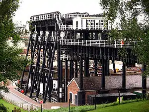
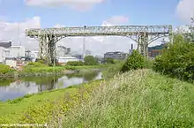
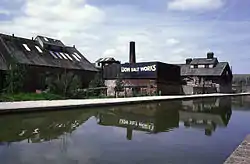
This list includes structures dating from the early post-medieval period, through the period of the Industrial Revolution, to sites prepared for warfare in the 20th century. The monuments from the earlier part of the period tend to be similar in type to those in the medieval period, namely moats or moated sites, and churchyard crosses and also include a dovecote and a duck decoy. Structures dating from the Industrial Revolution include the remains of a mine, canal locks and a bridge, a salt works, a boat lift, and a transporter bridge within a factory. The structures dating from the 20th century consist of a former Royal Air Force airfield and the remains of three sites for anti-aircraft guns.
|
 Beeston lock 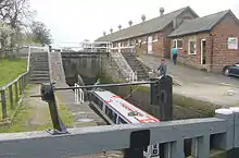 Bunbury locks 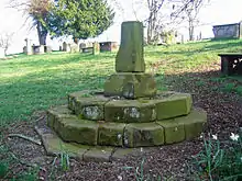 Over churchyard cross 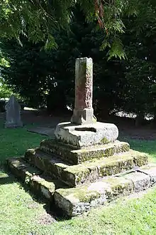 Shocklach churchyard cross 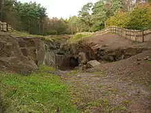 An entry to one of the mines in the West Mine Plant on Alderley Edge |
See also
References
- Revealing Cheshire's Past, archived from the original on 6 March 2009, retrieved 3 March 2009
- The Schedule of Monuments, English Heritage, archived from the original on 23 February 2009, retrieved 28 February 2009
- Historic England, "Anderton Boat Lift, aqueduct, basins, meter building, toll houses and buried remains of salt chutes, inclined planes, the east basin and dockside features (1021152)", National Heritage List for England, retrieved 13 December 2012
- Historic England, "Anderton Boat Lift (72982)", PastScape, retrieved 13 December 2012
- Revealing Cheshire's Past: Anderton Boat Lift, aqueduct, basins, meter building, toll houses, buried remains of salt chutes, inclined planes, the east basin and dockside feature, retrieved 30 January 2009
- Historic England, "The Armada Beacon, Alderley Edge (1019850)", National Heritage List for England, retrieved 13 December 2012
- Historic England, "Monument No. 76339 (76339)", PastScape, retrieved 13 December 2012
- Revealing Cheshire's Past: The Armada Beacon, retrieved 6 April 2009
- Historic England, "Dovecote at the site of Aston Old Hall, 40m east of Gamekeepers Cottage (1018703)", National Heritage List for England, retrieved 13 December 2012
- Historic England, "Monument No. 1195093 (1195093)", PastScape, retrieved 13 December 2012
- Revealing Cheshire's Past: Dovecote at site of Aston Old Hall, 40m east of Gamekeepers Cottage, retrieved 6 February 2009
- Historic England, "Bank Quay transporter bridge, Warrington (1006768)", National Heritage List for England, retrieved 13 December 2012
- Historic England, "Bank Quay Transporter Bridge (71703)", PastScape, retrieved 13 December 2012
- Revealing Cheshire's Past: Bank Quay Transporter Bridge, retrieved 23 January 2009
- Historic England, "Transporter Bridge to part of Joseph Crosfield and Sons Ltd's Works, Warrington (1139433)", National Heritage List for England, retrieved 13 December 2012
- Historic England, "Beeston Iron Lock (71068)", PastScape, retrieved 13 December 2012
- Revealing Cheshire's Past: Beeston Cast Iron Lock, retrieved 19 January 2009
- Historic England, "Bunbury locks, bridge and stables (1006766)", National Heritage List for England, retrieved 13 December 2012
- Historic England, "Bunbury locks (71064)", PastScape, retrieved 13 December 2012
- Revealing Cheshire's Past: Bunbury Locks, Bridge and Stables, retrieved 21 January 2009
- Historic England, "Shropshire Union Canal Bunbury locks (1115812)", National Heritage List for England, retrieved 13 December 2012
- Historic England, "Icehouse 110m south west of Burton Manor College main building (1016918)", National Heritage List for England, retrieved 13 December 2012
- Historic England, "Monument No. 1194396 (1194396)", PastScape, retrieved 13 December 2012
- Revealing Cheshire's Past: Ice House 110m southwest of Burton Manor College main building, retrieved 3 February 2009
- Historic England, "Crossley Bridge or Colleymill Bridge (1006772)", National Heritage List for England, retrieved 13 December 2012
- Historic England, "Colleymill or Crossley Bridge (76200)", PastScape, retrieved 13 December 2012
- Revealing Cheshire's Past: Crossley Bridge or Colleymill Bridge, retrieved 19 January 2009
- Historic England, "Colley Mill Bridge (1159386)", National Heritage List for England, retrieved 13 December 2012
- Historic England, "Danebower Colliery ventilation chimney, 750m north east of Holt (1018820)", National Heritage List for England, retrieved 13 December 2012
- Historic England, "Monument No. 1194373 (1194373)", PastScape, retrieved 13 December 2012
- Revealing Cheshire's Past: Danebower Colliery Airshaft Chimney, retrieved 6 April 2009
- Historic England, "Daresbury (1417593)", National Heritage List for England, retrieved 29 March 2014
- Historic England, "Former soda ash and calcium nitrate works (1450800)", National Heritage List for England, retrieved 20 July 2018
- Historic England, "Gawsworth Hall gardens (1016587)", National Heritage List for England, retrieved 13 December 2012
- Historic England, "Monument No. 1063161 (1063161)", PastScape, retrieved 13 December 2012
- Revealing Cheshire's Past: Gawsworth Old Hall Garden, retrieved 21 January 2009
- Revealing Cheshire's Past: Gawsworth Old Hall Garden Walls, retrieved 21 January 2009
- Revealing Cheshire's Past: Gawsworth Old Hall, retrieved 21 January 2009
- Revealing Cheshire's Past: Wall Pool, retrieved 21 January 2009
- Revealing Cheshire's Past: Fifth pool at Gawsworth, retrieved 21 January 2009
- Revealing Cheshire's Past: Gawsworth Old Hall Gardens, retrieved 21 January 2009
- Revealing Cheshire's Past: Gawsworth Old Hall Gardens, retrieved 21 January 2009
- Historic England, "Icehouse with associated iceyard at Great Moreton Hall, 70m east of the hall gardens (1018705)", National Heritage List for England, retrieved 13 December 2012
- Historic England, "Monument No. 1195455 (1195455)", PastScape, retrieved 13 December 2012
- Revealing Cheshire's Past: Icehouse Tower at Great Moreton Hall, retrieved 23 January 2009
- Historic England, "Icehouse tower at Great Moreton Hall (1138737)", National Heritage List for England, retrieved 13 December 2012
- Historic England, "Duck decoy pond 200m south east of Marsh Bridge, Hale (1014717)", National Heritage List for England, retrieved 13 December 2012
- Historic England, "Monument No. 69741 (69741)", PastScape, retrieved 13 December 2012
- Revealing Cheshire's Past: Duck Decoy Pond, retrieved 17 January 2009
- Halton Duck Decoy, Halton Borough Council, archived from the original on 3 April 2008, retrieved 2 March 2009
- Historic England, "Huntington Hall moated site (1012112)", National Heritage List for England, retrieved 13 December 2012
- Historic England, "Huntington Hall (69302)", PastScape, retrieved 13 December 2012
- Revealing Cheshire's Past: Huntington Hall Moated Site, retrieved 2009-01-23
- Historic England, "Dovecote and pigstys 270m south east of Jodrell Bank Farm (1018704)", National Heritage List for England, retrieved 13 December 2012
- Historic England, "Monument No. 1195139 (1195139)", PastScape, retrieved 13 December 2012
- Revealing Cheshire's Past: Terra Nova School, retrieved 6 April 2009
- Historic England, "Kinderton Hall moated site, two annexes, five fishponds, garden and prospect mound (1012358)", National Heritage List for England, retrieved 13 December 2012
- Historic England, "Monument No. 74705 (74705)", PastScape, retrieved 13 December 2012
- Revealing Cheshire's Past: Kinderton Hall gardens, retrieved 23 January 2009
- Historic England, "Lion Salt Works and remains of part of the Alliance Salt Works (1020841)", National Heritage List for England, retrieved 13 December 2012
- Historic England, "Lion Salt Works (1362066)", PastScape, retrieved 13 December 2012
- Historic England, "Alliance Salt Works (973072)", PastScape, retrieved 13 December 2012
- Revealing Cheshire's Past: Lion Salt Works, retrieved 2009-02-06
- Historic England, "Pan Sheds and Stoves and Store Shed behind Lion Salt Works (1329875)", National Heritage List for England, retrieved 13 December 2012
- Historic England, "Office in Works Yard, Lion Salt Works (1139103)", National Heritage List for England, retrieved 13 December 2012
- Historic England, "Engine shed and Pump House at Lion Salt Works (1160985)", National Heritage List for England, retrieved 13 December 2012
- Historic England, "Canal Salt Shed at Lion Salt Works (1329876)", National Heritage List for England, retrieved 13 December 2012
- Historic England, "Two cockpits 125m west of Lymm Hall (1018340)", National Heritage List for England, retrieved 13 December 2012
- Historic England, "Monument No. 931357 (931357)", PastScape, retrieved 13 December 2012
- Revealing Cheshire's Past: Two cockpits 125m west of Lymm Hall, retrieved 6 April 2009
- Historic England, "Marton moated monastic grange, three fishponds, connecting channels and base of stone cross (1009863)", National Heritage List for England, retrieved 13 December 2012
- Historic England, "Marton Grange (72878)", PastScape, retrieved 13 December 2012
- Revealing Cheshire's Past: Marton Grange, retrieved 23 January 2009
- Historic England, "Murgatroyd's Brine Works (1020122)", National Heritage List for England, retrieved 16 December 2012
- Historic England, "Monument No. 1346105 (1346105)", PastScape, retrieved 16 December 2012
- Revealing Cheshire's Past: Brine pumps at Brooks Lane, retrieved 6 April 2009
- Historic England, "Standing cross in St Mary's churchyard, Newbold Astbury (1020625)", National Heritage List for England, retrieved 16 December 2012
- Historic England, "Monument No. 1258741 (1258741)", PastScape, retrieved 16 December 2012
- Revealing Cheshire's Past: Standing Cross St Mary's churchyard, retrieved 25 January 2009
- Historic England, "Cross base and shaft in Churchyard of St. Mary, Newbold Astbury (1138741)", National Heritage List for England, retrieved 16 December 2012
- Historic England, "Heavy Anti-aircraft Battery at Norley 365m south east of Finger Post Farm (1020982)", National Heritage List for England, retrieved 16 December 2012
- Historic England, "Monument No. 1323912 (1323912)", PastScape, retrieved 16 December 2012
- Revealing Cheshire's Past: Heavy Anti Aircraft Battery at Norley 365m SE of Finger Post Farm, retrieved 6 February 2009
- Historic England, "Standing cross in the churchyard of St Chad's Church, Over, 10m from the south wall of the chancel (1013782)", National Heritage List for England, retrieved 16 December 2012
- Revealing Cheshire's Past: Standing Cross, St Chad's Church, Over, retrieved 25 January 2009
- Historic England, "Cross base in churchyard of St Chad, Over (1310386)", National Heritage List for England, retrieved 16 December 2012
- Historic England, "Medieval and post-medieval settlement remains and associated field system immediately east of Overton Hall (1016589)", National Heritage List for England, retrieved 16 December 2012
- Historic England, "Monument No. 68710 (68710)", PastScape, retrieved 16 December 2012
- Revealing Cheshire's Past: Medieval & Post Medieval settlement remains & associated field system immediately E of Overton Hall, retrieved 3 February 2009
- Historic England, "Pickett-Hamilton fort 600m south east of Limekiln Farm (1020869)", National Heritage List for England, retrieved 16 December 2012
- Historic England, "Monument No. 1372811 (1372811)", PastScape, retrieved 16 December 2012
- Revealing Cheshire's Past: Pickett-Hamilton fort, retrieved 30 March 2009
- Historic England, "Icehouse at the site of Poynton Hall, 170m north of Towers Yard Farm (1018819)", National Heritage List for England, retrieved 16 December 2012
- Historic England, "Monument No. 1194872 (1194872)", PastScape, retrieved 16 December 2012
- Revealing Cheshire's Past: Ice House at site of Poynton Hall, retrieved 6 April 2009
- Historic England, "Icehouse, Poynton (1277105)", National Heritage List for England, retrieved 16 December 2012
- Historic England, "Heavy Anti-aircraft gunsite, 250m north east of New Farm Cottages (1019848)", National Heritage List for England, retrieved 16 December 2012
- Historic England, "Heavy Anti Aircraft Battery Mersey H21 (1340983)", PastScape, retrieved 16 December 2012
- Revealing Cheshire's Past: Heavy Anti-aircraft gunsite, 250m north east of New Farm Cottages, retrieved 8 February 2009
- Historic England, "World War II defences of the former airfield of RAF Cranage (1020762)", National Heritage List for England, retrieved 16 December 2012
- Historic England, "RAF Cranage (1365531)", PastScape, retrieved 16 December 2012
- Revealing Cheshire's Past: RAF Cranage Airfield, retrieved 6 February 2009
- Revealing Cheshire's Past: RAF Cranage Airfield Defences - Battle Head Quarters, retrieved 6 February 2009
- Revealing Cheshire's Past: RAF Cranage Airfield Defences - Aircrew Sleeping Shelter, retrieved 6 February 2009
- Revealing Cheshire's Past: RAF Cranage Airfield Defences - western pillbox, retrieved 6 February 2009
- Revealing Cheshire's Past: RAF Cranage Airfield Defences - northern pillbox, retrieved 6 February 2009
- Revealing Cheshire's Past: RAF Cranage Airfield Defences - southern pillbox, retrieved 6 February 2009
- Revealing Cheshire's Past: RAF Cranage Airfield Defences - eastern pillbox, retrieved 6 February 2009
- Historic England, "Standing cross in St Edith's churchyard, Church Shocklach (1018076)", National Heritage List for England, retrieved 16 December 2012
- Historic England, "Monument No. 68882 (68882)", PastScape, retrieved 16 December 2012
- Revealing Cheshire's Past: Standing cross in St Edith's churchyard, retrieved 23 January 2009
- Historic England, "Medieval Cross in St Edith's Churchyard, South of Church, Church Shocklach (1228350)", National Heritage List for England, retrieved 16 December 2012
- Historic England, "Heavy Anti-aircraft gunsite, 400m west of Sutton Fields Farm (1019849)", National Heritage List for England, retrieved 16 December 2012
- Historic England, "Heavy anti aircraft battery Mersey H18 (1412952)", PastScape, retrieved 16 December 2012
- Revealing Cheshire's Past: Heavy Anti-aircraft gunsite, 400m west of Sutton Fields Farm, retrieved 6 February 2009
- Historic England, "Garden gateway at Tilstone Hall 130m south of Tilstone Hall Farm (1018339)", National Heritage List for England, retrieved 21 December 2012
- Historic England, "Monument No. 1184571 (1184571)", PastScape, retrieved 21 December 2012
- Revealing Cheshire's Past: Garden gateway at Tilstone hall, retrieved 6 April 2009
- Historic England, "Tilstone Hall Folly (1160231)", National Heritage List for England, retrieved 21 December 2012
- Historic England, "Wood Mine cobalt works and associated mines, 340m east of White Barn Farm (1020181)", National Heritage List for England, retrieved 21 December 2012
- Historic England, "Wood Mine Ore Treatment Works (1461902)", PastScape, retrieved 21 December 2012
- Revealing Cheshire's Past: West Mine Acid Leaching Plant and Copper Precipitation Tanks, retrieved 19 January 2009
- Revealing Cheshire's Past: West Mine - Wood Mine Tramway, retrieved 19 January 2009
- Revealing Cheshire's Past: West Mine - Wood Mine Adit 'Scout Hole', retrieved 19 January 2009
- Revealing Cheshire's Past: West Mine - West Mine Cottages, retrieved 24 January 2009
- Revealing Cheshire's Past: West Mine Workings of Cobalt fault, retrieved 24 January 2009
- Revealing Cheshire's Past: West Mine Building Remains, retrieved 24 January 2009
- Revealing Cheshire's Past: West Mine, retrieved 24 January 2009
- Revealing Cheshire's Past: West Mine OpenCast, retrieved 24 January 2009
- Revealing Cheshire's Past: West Mine Engine Winding House, retrieved 24 January 2009
- Revealing Cheshire's Past: Well at West Mine, retrieved 24 January 2009
- Historic England, "Wrenbury wooden lifting bridge (1004639)", National Heritage List for England, retrieved 21 December 2012
- Historic England, "Wrenbury Bridge (70942)", PastScape, retrieved 21 December 2012
- Revealing Cheshire's Past: Wrenbury Wooden Lifting Bridge, retrieved 19 January 2009
- Historic England, "Wrenbury bridge (1357425)", National Heritage List for England, retrieved 21 December 2012
