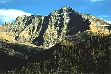
Mount Cleveland (Montana)
Mount Cleveland is the highest mountain in Glacier National Park, located in Montana, United States.[3] It is also the highest point in the Lewis Range, which spans part of the northern portion of the Park and extends into Canada. It is located approximately 3 mi (4.8 km) southeast of the southern end of Waterton Lake, and approximately 5 mi (8.0 km) south of the US/Canada border. The east side of the future national park was purchased by the federal government from the Blackfoot Confederacy in 1895 during the second term of President Cleveland. According to the United States Board on Geographic Names, the mountain is named for the former president.
| Mount Cleveland | |
|---|---|
 Mount Cleveland | |
| Highest point | |
| Elevation | 10,479 ft (3,194 m) NAVD 88[1] |
| Prominence | 5,226 ft (1,593 m) [2] |
| Parent peak | Mount Evans[2] |
| Listing |
|
| Coordinates | 48°55′30″N 113°50′54″W [1] |
| Geography | |
 Mount Cleveland Location in Montana  Mount Cleveland Location in the United States | |
| Location | Glacier National Park, Glacier County, Montana, U.S. |
| Parent range | Lewis Range |
| Topo map | USGS Mount Cleveland |
| Climbing | |
| First ascent | 1920 Frank B. Wynn |
| Easiest route | West Face: Scramble class 3/4 |
- For other mountains by this name, see Mount Cleveland (disambiguation).
While not of great absolute elevation (the mountain is more than 2,300 ft (700 m) lower than Granite Peak, the highest peak in Montana), Mount Cleveland is notable for its large, steep rise above local terrain. For example, its west flank rises over 5,500 ft (1,700 m) in less than 2 mi (3.2 km); the northwest face, steepest on the mountain, rises 4,000 ft (1,200 m) in less than 0.4 mi (0.64 km). The other faces show almost as much vertical relief. This scale and steepness of relief is quite rare in the contiguous United States. Mount Cleveland is 50th on a list of peaks in the contiguous U.S. with the most topographic prominence.[4] The massif upon which Mount Cleveland is situated also includes 10,001-foot (3,048 m) Kaiser Point, which is the seventh tallest peak in the park and is only .67 mi (1.08 km) to the northeast.
The first recorded ascent of Mount Cleveland was in 1920 by Frank B. Wynn.[5] The easiest route on the peak is the West Face route, starting from the Waterton Valley; it is a scramble (Class 3) with the possibility of some short exposed sections (Class 4).[6]
Other routes include the Stoney Indian Route, from Stoney Indian Pass to the south of the peak, first descended by noted Sierra mountaineer Norman Clyde and party in 1937; various routes on the Southeast Face; and the more difficult North (or Northwest) Face, climbed partially in 1971 and completely in 1976.[6]
Although the peak has a relatively low fatality record, five Montana climbers were killed on the peak's west face in December 1969. The climbers were swept away by an avalanche and were not found for seven months. [7]
See also
References
- "Cleveland". NGS data sheet. U.S. National Geodetic Survey. Retrieved 2011-05-21.
- "Mount Cleveland". Peakbagger.com. Retrieved 2009-12-08.
- Mount Cleveland, MT (Map). TopoQwest (United States Geological Survey Maps). Retrieved June 4, 2018.
- "AMERICA'S 57 - the Ultras". 2005-05-19. Retrieved 2009-12-08.
- Walters, D. C. (2009), "Exploring a Definition of Leadership and the Biography of Dr. Frank B. Wynn 1860-1922", ProQuest: 214–220
- Edwards, J. Gordon (1995). A Climber's Guide to Glacier National Park. Falcon Press.
- Jenkins, McKay (1 February 2000). "And None Came Back". Outsider Online. Retrieved 7 March 2019.
External links
- "Mount Cleveland". Geographic Names Information System. United States Geological Survey. Retrieved 2009-12-08.
- "Mount Cleveland". SummitPost.org. Retrieved 2009-12-08.
