Northwest Branch Anacostia River
Northwest Branch Anacostia River is a 21.5-mile-long (34.6 km)[1] free-flowing stream in Montgomery County and Prince George's County, Maryland. It is a tributary of the Anacostia River, which flows to the Potomac River and the Chesapeake Bay.
| Northwest Branch Anacostia River | |
|---|---|
.jpg.webp) | |
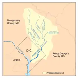 Map of the Anacostia River watershed showing the Northwest Branch | |
| Location | |
| Country | United States |
| State | Maryland |
| Cities | Wheaton, Silver Spring, Hyattsville |
| Physical characteristics | |
| Source | |
| • location | Sandy Spring, Maryland |
| Mouth | Anacostia River |
• location | Bladensburg, MD |
• coordinates | 38.942832°N 76.944036°W |
| Length | 21.5 mi (34.6 km) |
| Basin size | 53.5 sq mi (139 km2) |
| Basin features | |
| Tributaries | |
| • left | Old Orchard, Bryants Nursery, Norwood, Rolling Stone |
| • right | Bachelors Forest, Longmeade, Bel Pre Creek, Wheaton Park, Lamberton Dr, Sligo Creek |
Course
The headwaters of the Northwest Branch are located near the community of Sandy Spring.[2] The stream flows southward for 21.5 miles (34.6 km) to its confluence with the Northeast Branch near Bladensburg to form the main stem of the Anacostia.[3]
Watershed
The watershed in Montgomery County includes portions of the communities of Norwood, Bel Pre Manor, Colesville, Layhill, Glenmont, Wheaton, Hillandale, White Oak, Silver Spring, Kemp Mill, Four Corners and Takoma Park. The Prince George's County portion of the watershed includes Adelphi, Langley Park, University Park, Chillum, Hyattsville, Avondale and Brentwood. The total watershed area, including a small portion of land in Washington, D.C., is 53.5 square miles (139 km2), with a resident population of about 254,000.[4][5]
The middle section of the Northwest Branch is referred to as the Rachel Carson Environmental Area. It flows through a small gorge underneath the Capital Beltway between Colesville Road and Adelphi Mill. Located at the north end of the Northwest Branch Trail, near the home of noted environmental author Rachel Carson, it is deliberately left rustic and unimproved.[6]
The majority of the Northwest Branch stream valley is a riparian buffer, protected as parkland by the Maryland-National Capital Park and Planning Commission (M-NCPPC).[4] The Rachel Carson Greenway planned by M-NCPPC will extend the Northwest Branch Trail into northern Montgomery County as an unimproved hiking trail, connecting to the Anacostia Tributary Trail System in Prince George's County.
Geology
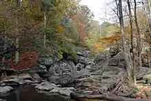
Northwest Branch crosses the geological fall line between the Piedmont and Atlantic coastal plain regions, which forms a small waterfall on the stream 0.5 miles (0.80 km) south of the Burnt Mills Dam parks.[7] This area was a favorite spot of Theodore Roosevelt.[8]
Tributaries
The total stream channel length of Northwest Branch and all tributaries is 75 miles (121 km).
- Bachelors Forest Tributary
- Bel Pre Creek
- Bryants Nursery Tributary
- Lamberton Drive Tributary
- Lockridge Drive Tributary
- Longmeade Tributary
- Norwood Tributary
- Old Orchard Tributary
- Rolling Stone Tributary
- Sandy Spring Tributary
- Sligo Creek
- Wheaton Park Tributary
See also
- List of Maryland rivers
- Anacostia Tributary Trails
References
- "The National Map". National Hydrography Dataset high-resolution flowline data. U.S. Geological Survey. Retrieved August 15, 2011.
- 39°08′46.9″N 77°02′08.3″W
- "Mission Statement". Neighbors of the Northwest Branch. Retrieved August 31, 2009.
- "Northwest Branch: Profile". Anacostia Watershed Restoration Partnership (AWRP). Washington, DC. January 6, 2016. Retrieved June 21, 2010.
- "Sligo Creek: Profile". AWRP. Retrieved June 21, 2010.
- "Rachel Carson Greenway & Northwest Branch Stream Valley Park Trails". Montgomery Parks/MNCPPC. Retrieved November 14, 2009.
- "Northwest Branch". DC Great Outdoors.
- Meyer, Eugene (November 21, 2009). "When Presidents Came to Visit". Bethesda Magazine.
Bibliography
- "Northwest Branch Watershed Study" (PDF). Montgomery County Department of Environmental Protection (MCDEP). Rockville, MD. March 17, 1997.
- "Countywide Stream Protection Strategy: Northwest Branch Watershed". MCDEP. Retrieved August 30, 2009.
- "Anacostia River Watershed Restoration Plan: Interim Report Framework". Anacostia Watershed Restoration Partnership. November 21, 2008.
Report to Congress
CS1 maint: date and year (link)
External links
- Neighbors of the Northwest Branch
- Anacostia Watershed Society - Detailed maps and photos of stream conditions
- Anacostia Watershed Restoration Partnership
- Northwest Branch Trail - Montgomery County Dept. of Parks
- Wheaton Regional Park - Montgomery County Dept. of Parks
- Anacostia Tributary Trail System - Prince George's County Dept. of Parks & Recreation
- Anacostia, Northwest Branch
- Northwest Branch Climbing Sections
| Authority control |
|
|---|