Pemba Airport (Tanzania)
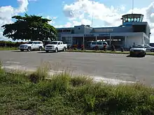
Pemba Airport (IATA: PMA, ICAO: HTPE) is an airport in the Zanzibar Archipelago located on Pemba Island. It is also known as Karume Airport and Wawi Airport. It is located approximately 7 kilometres (4.3 mi) southeast of Chake-Chake, the capital of the island. The Zanzibar government is looking into the possibility of renaming the airport to Thabit Kombo Jecha in recognition of his role in the Zanzibar Revolution.[3]
Pemba / Karume Airport Uwanja wa Ndege wa Pemba (Swahili) | |||||||||||
|---|---|---|---|---|---|---|---|---|---|---|---|
 | |||||||||||
| Summary | |||||||||||
| Airport type | Public | ||||||||||
| Owner | Government of Zanzibar | ||||||||||
| Operator | Zanzibar Airports Authority | ||||||||||
| Serves | Chake-Chake | ||||||||||
| Location | Pemba Island, Zanzibar | ||||||||||
| Elevation AMSL | 80 ft / 24 m | ||||||||||
| Coordinates | 5°15′30″S 39°48′40″E | ||||||||||
| Map | |||||||||||
 PMA Location of airport in Tanzania | |||||||||||
| Runways | |||||||||||
| |||||||||||
The Pemba non-directional beacon (Ident: PA) is located on the field.[4]
Airlines and destinations
| Airlines | Destinations |
|---|---|
| As Salaam Air | Tanga, Zanzibar |
| Auric Air | Dar es Salaam, Mwanza, Tanga, Zanzibar |
| Coastal Aviation | Arusha, Dar es Salaam, Kilwa, Tanga, Zanzibar[5] |
| Precision Air | Zanzibar |
| Tropical Air | Zanzibar |
| ZanAir | Arusha, Dar es Salaam, Zanzibar |
Accidents and Incidents
See also
 Tanzania portal
 Aviation portal
- List of airports in Tanzania
- Transport in Tanzania
References
- Airport information for PMA at Great Circle Mapper.
- Google Maps - Pemba
- "Zanzibar airports authority to improve services". Daily News, Tanzania. 27 January 2011. Archived from the original on 18 April 2013. Retrieved 19 January 2013.
- "SkyVector: Flight Planning / Aeronautical Charts". skyvector.com. Retrieved 28 August 2018.
- http://www.coastal.co.tz/destinations/pemba/
- Ranter, Harro. "Incident Let L-410UVP-E9 5H-ZAP, 24 Jan 2014". aviation-safety.net. Retrieved 28 August 2018.
This article is issued from Wikipedia. The text is licensed under Creative Commons - Attribution - Sharealike. Additional terms may apply for the media files.