San Isidro, Leyte
San Isidro, officially the Municipality of San Isidro (Cebuano: Lungsod sa San Isidro; Waray: Bungto han San Isidro; Tagalog: Bayan ng San Isidro), is a 4th class municipality in the province of Leyte, Philippines. According to the 2015 census, it has a population of 31,641 people. [3]
San Isidro | |
|---|---|
| Municipality of San Isidro | |
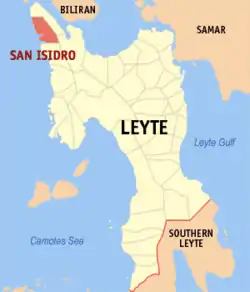 Map of Leyte with San Isidro highlighted | |
OpenStreetMap 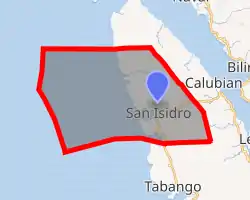
| |
.svg.png.webp) San Isidro Location within the Philippines | |
| Coordinates: 11°25′N 124°21′E | |
| Country | |
| Region | Eastern Visayas (Region VIII) |
| Province | Leyte |
| District | 3rd District |
| Barangays | 19 (see Barangays) |
| Government | |
| • Type | Sangguniang Bayan |
| • Mayor | Remedio B. Veloso |
| • Vice Mayor | Isidro C. Balmoria |
| • Representative | Vicente Sofronio E. Veloso III |
| • Councilors | List
|
| • Electorate | 22,367 voters (2019) |
| Area | |
| • Total | 122.50 km2 (47.30 sq mi) |
| Elevation | 34 m (112 ft) |
| Population | |
| • Total | 31,641 |
| • Density | 260/km2 (670/sq mi) |
| • Households | 7,861 |
| Economy | |
| • Income class | 4th municipal income class |
| • Poverty incidence | 41.92% (2015)[4] |
| • Revenue | ₱82,802,224.58 (2016) |
| Time zone | UTC+8 (PST) |
| ZIP code | 6535 |
| PSGC | |
| IDD : area code | +63 (0)53 |
| Climate type | tropical rainforest climate |
| Native languages | Cebuano Tagalog |
History
The Battle of Leyte Gulf during the Second World War is considered by most historians as the biggest naval battle in history. The scope of the encounter in terms of warships, warplanes, and manpower involved is nothing short of astounding. The casualties borne by both warring parties are incomparable to other similar engagements, to say the least. It was, by all standards, a decisive victory for the American naval forces and could easily have turned the tide in favor of the Japanese Imperial Navy had the result been otherwise.
The battle was waged in an attempt by the Japanese to thwart General Douglas MacArthur's bold return via the Leyte Landings on October 20, 1944, the second biggest amphibious invasion in modern history after the Normandy Invasion less than five months earlier. The Japanese naval forces organized three attack forces with the American landing armada in the Leyte Gulf as target. The largest attack group, organized hastily by the Japanese, was the Central Force headed by Admiral Kurita. This powerful force encountered a token fleet of American escort ships in the Philippine Sea off the island of Samar. Despite overwhelming superiority, the Japanese Central Force surprisingly retreated through the San Bernardino Strait. Part of the remnants of the Central Force was pursued and destroyed by American warplanes.
There are six sunken Japanese warships in San Isidro Bay, northwest of Leyte Island. The warships were destroyed on or about the same period when the Battle for Leyte Gulf was waged. This paper will attempt to establish the circumstances that led to the sinking and destruction of these ships. It will try to find out if the ill-fated vessels were among the remnants of the Japanese Central Force which retreated after almost bringing the Leyte Landings of the Allied Forces to their doom.
The Battle for Leyte Gulf was the most savage naval engagement of World War II.[5]
Barangays
Climate
| Climate data for San Isidro, Leyte | |||||||||||||
|---|---|---|---|---|---|---|---|---|---|---|---|---|---|
| Month | Jan | Feb | Mar | Apr | May | Jun | Jul | Aug | Sep | Oct | Nov | Dec | Year |
| Average high °C (°F) | 28 (82) |
29 (84) |
29 (84) |
31 (88) |
31 (88) |
30 (86) |
30 (86) |
30 (86) |
30 (86) |
29 (84) |
29 (84) |
29 (84) |
30 (85) |
| Average low °C (°F) | 22 (72) |
22 (72) |
22 (72) |
23 (73) |
24 (75) |
25 (77) |
25 (77) |
25 (77) |
25 (77) |
24 (75) |
24 (75) |
23 (73) |
24 (75) |
| Average precipitation mm (inches) | 73 (2.9) |
56 (2.2) |
75 (3.0) |
71 (2.8) |
114 (4.5) |
174 (6.9) |
172 (6.8) |
163 (6.4) |
167 (6.6) |
161 (6.3) |
158 (6.2) |
125 (4.9) |
1,509 (59.5) |
| Average rainy days | 15.2 | 12.5 | 16.2 | 17.3 | 23.9 | 27.3 | 28.4 | 26.9 | 26.9 | 27.1 | 23.8 | 19.3 | 264.8 |
| Source: Meteoblue [6] | |||||||||||||
Demographics
|
| ||||||||||||||||||||||||||||||||||||||||||
| Source: Philippine Statistics Authority [3] [7] [8][9] | |||||||||||||||||||||||||||||||||||||||||||
In the 2015 census, the population of San Isidro, Leyte, was 31,641 people, [3] with a density of 260 inhabitants per square kilometre or 670 inhabitants per square mile.
References
- Municipality of San Isidro | (DILG)
- "Province: Leyte". PSGC Interactive. Quezon City, Philippines: Philippine Statistics Authority. Retrieved 12 November 2016.
- Census of Population (2015). "Region VIII (Eastern Visayas)". Total Population by Province, City, Municipality and Barangay. PSA. Retrieved 20 June 2016.
- "PSA releases the 2015 Municipal and City Level Poverty Estimates". Quezon City, Philippines. Retrieved 12 October 2019.
- "Sunken Warships in San Isidro, Leyte". "ejournals.ph". Retrieved January 17, 2019.
- "San Isidro: Average Temperatures and Rainfall". Meteoblue. Retrieved 29 February 2020.
- Census of Population and Housing (2010). "Region VIII (Eastern Visayas)". Total Population by Province, City, Municipality and Barangay. NSO. Retrieved 29 June 2016.
- Censuses of Population (1903–2007). "Region VIII (Eastern Visayas)". Table 1. Population Enumerated in Various Censuses by Province/Highly Urbanized City: 1903 to 2007. NSO.
- "Province of Leyte". Municipality Population Data. Local Water Utilities Administration Research Division. Retrieved 17 December 2016.
External links
- San Isidro Profile at PhilAtlas.com
- Philippine Standard Geographic Code
- Philippine Census Information
- Local Governance Performance Management System
Places adjacent to San Isidro, Leyte | ||||||||||
|---|---|---|---|---|---|---|---|---|---|---|
| ||||||||||
Tacloban (capital) | |
| Municipalities |
|
| Component city | |
| Independent component city |
|
| Highly urbanized city |
|