Starý Poddvorov
Starý Poddvorov is a municipality and village in Hodonín District in the South Moravian Region of the Czech Republic. It has about 1,000 inhabitants.
Starý Poddvorov | |
|---|---|
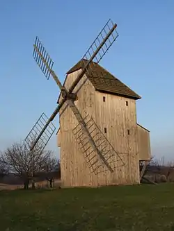 Wind mill from 1870 | |
 Flag  Coat of arms | |
 Starý Poddvorov Location in the Czech Republic | |
| Coordinates: 48°52′29″N 16°59′17″E | |
| Country | |
| Region | South Moravian |
| District | Hodonín |
| First mentioned | 1704 |
| Area | |
| • Total | 5.45 km2 (2.10 sq mi) |
| Elevation | 224 m (735 ft) |
| Population (2020-01-01[1]) | |
| • Total | 959 |
| • Density | 180/km2 (460/sq mi) |
| Time zone | UTC+1 (CET) |
| • Summer (DST) | UTC+2 (CEST) |
| Postal code | 696 16 |
| Website | www |
Starý Poddvorov lies approximately 12 kilometres (7 mi) west of Hodonín, 46 km (29 mi) south-east of Brno, and 230 km (143 mi) south-east of Prague.
Twin towns – sister cities
Starý Poddvorov is a member of the Charter of European Rural Communities, a town twinning association across the European Union, alongside with:[2]
 Bienvenida, Spain
.svg.png.webp) Bièvre, Belgium
Bièvre, Belgium Bucine, Italy
 Cashel, Ireland
 Cissé, France
 Desborough, England, United Kingdom
 Esch (Haaren), Netherlands
 Hepstedt, Germany
 Ibănești, Romania
 Kandava, Latvia
 Kannus, Finland
 Kolindros, Greece
 Lassee, Austria
 Medzev, Slovakia
 Moravče, Slovenia
 Næstved, Denmark
 Nagycenk, Hungary
 Nadur, Malta
 Ockelbo, Sweden
 Pano Lefkara, Cyprus
 Põlva, Estonia
 Samuel (Soure), Portugal
 Slivo Pole, Bulgaria
 Strzyżów, Poland
 Tisno, Croatia
 Troisvierges, Luxembourg
 Žagarė (Joniškis), Lithuania
References
- "Population of Municipalities – 1 January 2020". Czech Statistical Office. 2020-04-30.
- "Charter members". europeancharter.eu. Charter of European Rural Communities. Retrieved 2020-09-15.
This article is issued from Wikipedia. The text is licensed under Creative Commons - Attribution - Sharealike. Additional terms may apply for the media files.