Texas State Highway 184
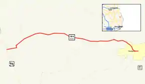
State Highway 184 (SH 184) is a Texas state highway running 11.079 miles (17.830 km) from Bronson east to Hemphill. This route was designated on November 30, 1932, along its current route,[2] and traverses several highly scenic vistas as it meanders through the Texas landscape. This highway was SH 87A before March 19, 1930, and this highway was erroneously omitted from the March 19, 1930 highway log.
| ||||
|---|---|---|---|---|
 | ||||
| Route information | ||||
| Maintained by TxDOT | ||||
| Length | 11.079 mi[1] (17.830 km) | |||
| Existed | 1932–present | |||
| Major junctions | ||||
| West end | ||||
| East end | ||||
| Highway system | ||||
| ||||
Major Junctions
The entire route is in Sabine County.
| Location | mi | km | Destinations | Notes | |
|---|---|---|---|---|---|
| Bronson | Western terminus | ||||
| West end of SH 184 / FM 1 overlap | |||||
| East end of SH 184 / FM 1 overlap | |||||
| | |||||
| | |||||
| Hemphill | Eastern terminus | ||||
1.000 mi = 1.609 km; 1.000 km = 0.621 mi
| |||||
References
- Transportation Planning and Programming Division (n.d.). "State Highway No. 184". Highway Designation Files. Texas Department of Transportation. Retrieved July 18, 2018.
- (PDF) https://publicdocs.txdot.gov/minord/MinuteOrderDocLib/003673821.pdf. Missing or empty
|title=(help)
This article is issued from Wikipedia. The text is licensed under Creative Commons - Attribution - Sharealike. Additional terms may apply for the media files.
