Third Avenue–149th Street station
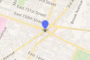
Third Avenue–149th Street is a station on the IRT White Plains Road Line of the New York City Subway. It is located at Third Avenue and East 149th Street (the latter of which is also known as Eugenio Maria de Hostos Boulevard) in the Hub in the South Bronx adjacent to Mott Haven and Melrose. The station is served by the 2 train at all times and the 5 train at all times except nights. The station is the second-busiest in the Bronx and 58th overall, with 6.7 million passengers as of 2018.[3]
3 Avenue–149 Street | ||||||||||||||||||||||||||||||||||||||||||||||||||||||||||||||||||||||||||||||||||||||||||||||||||||||||||||||
|---|---|---|---|---|---|---|---|---|---|---|---|---|---|---|---|---|---|---|---|---|---|---|---|---|---|---|---|---|---|---|---|---|---|---|---|---|---|---|---|---|---|---|---|---|---|---|---|---|---|---|---|---|---|---|---|---|---|---|---|---|---|---|---|---|---|---|---|---|---|---|---|---|---|---|---|---|---|---|---|---|---|---|---|---|---|---|---|---|---|---|---|---|---|---|---|---|---|---|---|---|---|---|---|---|---|---|---|---|---|---|
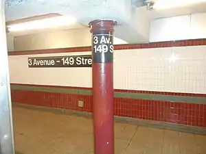
 The pillar and wall with their own signs as seen from the doors of a train. | ||||||||||||||||||||||||||||||||||||||||||||||||||||||||||||||||||||||||||||||||||||||||||||||||||||||||||||||
| Station statistics | ||||||||||||||||||||||||||||||||||||||||||||||||||||||||||||||||||||||||||||||||||||||||||||||||||||||||||||||
| Address | East 149th Street, Third, Willis & Melrose Avenues Bronx, NY 10455 | |||||||||||||||||||||||||||||||||||||||||||||||||||||||||||||||||||||||||||||||||||||||||||||||||||||||||||||
| Borough | The Bronx | |||||||||||||||||||||||||||||||||||||||||||||||||||||||||||||||||||||||||||||||||||||||||||||||||||||||||||||
| Locale | The Hub, Mott Haven | |||||||||||||||||||||||||||||||||||||||||||||||||||||||||||||||||||||||||||||||||||||||||||||||||||||||||||||
| Coordinates | 40.816099°N 73.917676°W | |||||||||||||||||||||||||||||||||||||||||||||||||||||||||||||||||||||||||||||||||||||||||||||||||||||||||||||
| Division | A (IRT) | |||||||||||||||||||||||||||||||||||||||||||||||||||||||||||||||||||||||||||||||||||||||||||||||||||||||||||||
| Line | IRT White Plains Road Line | |||||||||||||||||||||||||||||||||||||||||||||||||||||||||||||||||||||||||||||||||||||||||||||||||||||||||||||
| Services | 2 5 | |||||||||||||||||||||||||||||||||||||||||||||||||||||||||||||||||||||||||||||||||||||||||||||||||||||||||||||
| Transit | ||||||||||||||||||||||||||||||||||||||||||||||||||||||||||||||||||||||||||||||||||||||||||||||||||||||||||||||
| Structure | Underground | |||||||||||||||||||||||||||||||||||||||||||||||||||||||||||||||||||||||||||||||||||||||||||||||||||||||||||||
| Platforms | 2 side platforms | |||||||||||||||||||||||||||||||||||||||||||||||||||||||||||||||||||||||||||||||||||||||||||||||||||||||||||||
| Tracks | 2 | |||||||||||||||||||||||||||||||||||||||||||||||||||||||||||||||||||||||||||||||||||||||||||||||||||||||||||||
| Other information | ||||||||||||||||||||||||||||||||||||||||||||||||||||||||||||||||||||||||||||||||||||||||||||||||||||||||||||||
| Opened | July 10, 1905 | |||||||||||||||||||||||||||||||||||||||||||||||||||||||||||||||||||||||||||||||||||||||||||||||||||||||||||||
| Station code | 434[1] | |||||||||||||||||||||||||||||||||||||||||||||||||||||||||||||||||||||||||||||||||||||||||||||||||||||||||||||
| Accessible | ||||||||||||||||||||||||||||||||||||||||||||||||||||||||||||||||||||||||||||||||||||||||||||||||||||||||||||||
| Opposite- direction transfer | No | |||||||||||||||||||||||||||||||||||||||||||||||||||||||||||||||||||||||||||||||||||||||||||||||||||||||||||||
| Traffic | ||||||||||||||||||||||||||||||||||||||||||||||||||||||||||||||||||||||||||||||||||||||||||||||||||||||||||||||
| 2019 | 6,768,255[2] | |||||||||||||||||||||||||||||||||||||||||||||||||||||||||||||||||||||||||||||||||||||||||||||||||||||||||||||
| Rank | 59 out of 424[2] | |||||||||||||||||||||||||||||||||||||||||||||||||||||||||||||||||||||||||||||||||||||||||||||||||||||||||||||
| Station succession | ||||||||||||||||||||||||||||||||||||||||||||||||||||||||||||||||||||||||||||||||||||||||||||||||||||||||||||||
| Next north | East 180th Street (express): 5 Jackson Avenue (local): 2 | |||||||||||||||||||||||||||||||||||||||||||||||||||||||||||||||||||||||||||||||||||||||||||||||||||||||||||||
| Next south | 149th Street–Grand Concourse: 2 | |||||||||||||||||||||||||||||||||||||||||||||||||||||||||||||||||||||||||||||||||||||||||||||||||||||||||||||
| ||||||||||||||||||||||||||||||||||||||||||||||||||||||||||||||||||||||||||||||||||||||||||||||||||||||||||||||
| ||||||||||||||||||||||||||||||||||||||||||||||||||||||||||||||||||||||||||||||||||||||||||||||||||||||||||||||
| ||||||||||||||||||||||||||||||||||||||||||||||||||||||||||||||||||||||||||||||||||||||||||||||||||||||||||||||
| ||||||||||||||||||||||||||||||||||||||||||||||||||||||||||||||||||||||||||||||||||||||||||||||||||||||||||||||
History

The station opened on July 10, 1905, along with the 149th Street–Grand Concourse station and the connection with the IRT Lenox Avenue Line in Manhattan. Free transfers were provided between the subway and the existing 149th Street elevated station of the IRT Third Avenue Line, which opened in 1887.[4][5] The convergence of the two rapid transit lines, the surface trolley lines along Third Avenue and 149th Street, and the ensuing commercial development led to the coining of the name "the Hub" for the intersection in the early 20th century.[5][6]
Following the closure of the Third Avenue elevated in 1973,[7][8] free paper transfers were provided between the subway and the Bx55 limited-stop bus, which replaced the elevated.[9][10][11][12] However, scalpers would often resell these transfers for 50 cents.[13] Because of the unique transfer, the station was one of the first to test the MetroCard system in the early 1990s,[11] and the paper transfers were finally scrapped in 1997 with the wider rollout of the MetroCard.[14]
In 1981, the MTA listed the station among the 69 most deteriorated stations in the subway system.[15]
Station layout
| G | Street level | Exit/entrance |
| P Platform level |
Side platform | |
| Northbound | ← ← ← | |
| Southbound | | |
| Side platform | ||
The station has two tracks and two side platforms, with no crossovers between the platforms. The station has been renovated, with ADA-accessible elevators installed on both sides of the station.
The station tiles have dark red and dark green/gray lower accents and dark red upper border. There are ceramic mosaics, installed in 1996 under the MTA's Arts for Transit program, entitled Una Raza, Un Mundo, Universo (One Race, One World, One Universe), by Jose Ortega. Four such mosaics are on each platform near the fare control.[16] The token booths are built into the wall. Prior to the renovation, terra cotta "3" plaques were on the platform walls. One of these has been preserved at the New York Transit Museum.
Immediately east (railroad north) of the station, past Bergen Avenue, the tracks ascend to become an elevated structure for the trip to East 180th Street. This is the longest section of elevated track built under IRT Contract I. At the El level, one can still see the shortened supports for former track connections with the Third Avenue El.[17] The express run to the next express station north, East 180th Street is 3.4 miles (5.5 km) long and bypasses seven stations, making it the second-longest express run in the system behind the 3.5-mile (5.6 km) express run between 125th Street and 59th Street–Columbus Circle on the IND Eighth Avenue Line, which also bypasses seven stations.
Exits
The fare control is at platform level and there is a closed crossunder. Each fare control area has a bus transfer booth, which was used for the connection to the former Bx55 bus route that replaced the IRT Third Avenue Line in the Bronx. The extra booths and turnstiles, while still present, are no longer in use, having closed in July 1997 when system-wide free transfers were introduced with the MetroCard.[18]
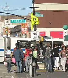
For each platform, three staircases lead up from fare control to the street; the north side of 149th Street for the Manhattan-bound platform, and the south side for the Bronx-bound platform. The elevators are located on the west side of the intersection.[19][20]
Points of interest
The station is located in the Hub, the oldest major shopping locale in the Bronx.[21]
Nearby points of interest include:
- Alfred E. Smith Career and Technical Education High School[19]
- Bronx Opera House[19]
- College of New Rochelle, John Cardinal O'Connor Campus.[19]
- Patterson Houses[19]
- South Bronx Educational Campus, formerly South Bronx High School.[19]
See also
References
- "Station Developers' Information". Metropolitan Transportation Authority. Retrieved June 13, 2017.
- "Facts and Figures: Annual Subway Ridership 2014–2019". Metropolitan Transportation Authority. 2020. Retrieved May 26, 2020.
- "Subway Trains Running From Bronx to Battery" (PDF). The New York Times. July 10, 1905. ISSN 0362-4331. Archived (PDF) from the original on March 24, 2020. Retrieved October 4, 2011.
- Herzberg, Joseph G. (September 4, 1972). "The Bronx Had Everything, Including Own Shows" (PDF). The New York Times. ISSN 0362-4331. Retrieved October 7, 2015.
-
- "Bronx Has New Crosstown Trolley Line Entering Manhattan Through 149th Street" (PDF). The New York Times. October 22, 1911. ISSN 0362-4331. Archived (PDF) from the original on March 24, 2020. Retrieved October 7, 2015.
- "Crosstown Line Between Broadway and the Bronx At 149th Street" (PDF). The New York Times. May 7, 1911. ISSN 0362-4331. Archived (PDF) from the original on March 24, 2020. Retrieved October 7, 2015.
- "The Real Estate Field – Bronx Plot Sells for $200 a Front Foot – John D. Rockefeller, Jr., Takes Title to the Francis S. Kinney House – $148,000 Paid for Theatre and Office Building Site in Jamaica, L.I." (PDF). The New York Times. March 2, 1912. ISSN 0362-4331. Retrieved October 7, 2015.
- "The Real Estate Field – Bronx Plot Sells for $200 a Front Foot – John D. Rockefeller, Jr., Takes Title to the Francis S. Kinney House – $148,000 Paid for Theatre and Office Building Site in Jamaica, L.I." (PDF). The New York Times. March 3, 1912. ISSN 0362-4331. Archived (PDF) from the original on March 24, 2020. Retrieved October 7, 2015.
- Donovan, Aaron (July 29, 2001). "If You're Thinking of Living In/Belmont; Close-Knit Bronx Area With Italian Aura". The New York Times. ISSN 0362-4331. Archived from the original on March 24, 2020. Retrieved March 24, 2020.
- Blumenthal, Ralph (August 27, 1977). "Now That El's Gone, Bronx Hub Sees a Brighter Future" (PDF). The New York Times. Retrieved September 24, 2015.
- Seigel, Max H. (July 18, 1972). "City Plans to Raze 3d Ave. El in Bronx" (PDF). The New York Times. ISSN 0362-4331. Retrieved September 24, 2015.
- "The 3rd Avenue Corridor". The Bronx Journal. March 27, 2013. Archived from the original on March 28, 2019. Retrieved September 24, 2015.
- Faison, Seth (November 18, 1992). "Bronx Bus Line Riders Get Glimpse of Future". The New York Times. ISSN 0362-4331. Retrieved September 24, 2015.
- "3d Avenue El Closes Saturday; Fleet of 60 Buses to Replace It" (PDF). The New York Times. April 22, 1973. ISSN 0362-4331. Retrieved October 7, 2015.
- Almeida, Miguel (February 26, 1995). "NEIGHBORHOOD REPORT: SOUTH BRONX; Business Is Booming for the Hub's Transfer Hucksters". The New York Times. ISSN 0362-4331. Retrieved March 24, 2020.
- "Transfer Scheme Ends". The New York Times. July 8, 1997. ISSN 0362-4331. Retrieved March 24, 2020.
- Gargan, Edward A. (June 11, 1981). "Agency Lists Its 69 Most Deteriorated Subway Stations". The New York Times. p. B5. Retrieved August 13, 2016.
- Cotter, Holland (May 7, 1999). "Way Up in the Bronx A Hardy Spirit Blooms". The New York Times. p. E29. Retrieved October 7, 2015.
- "30 Hurt, 500 in Peril in Odd Train Wreck on 3d Av. Elevated – Cars Jump the Rails at Switch and Dash a Signal Tower to Pieces – Flames Menace Wreckage – Police Climb From Street and Put Out the Fire With Sand – Debris Hits Man in Street – Six Among the Victims Seriously Injured – Towerman Disappears – Bronx Prosecutor to Investigate" (PDF). The New York Times. May 31, 1921. p. 1. Retrieved October 7, 2015.
- "Transfer Scheme Ends". The New York Times. July 8, 1997. p. B3. Retrieved October 7, 2015.
- "Third Avenue–149th Street Neighborhood Map" (PDF). new.mta.info. Metropolitan Transportation Authority. April 2018. Retrieved February 28, 2019.
- "NYC Official Accessibility Guide" (PDF). nyc.gov. City of New York. 2008. Archived from the original (PDF) on August 7, 2015. Retrieved September 20, 2015.
- Community Board District 1, The South Bronx. Accessed September 23, 2007.
External links
| Wikimedia Commons has media related to Third Avenue – 149th Street (IRT White Plains Road Line). |
- nycsubway.org – IRT White Plains Road Line: 3rd Avenue/149th Street
- nycsubway.org — Una Raza, Un Mundo, Universo (One Race, One World, One Universe) Artwork by Jose Ortega (1996)
- Station Reporter — 2 Train
- Station Reporter — 5 Train
- The Subway Nut — 3rd Avenue–149th Street Pictures
- MTA's Arts For Transit — 3rd Avenue–149th Street (IRT White Plains Road Line)
- Third Avenue entrance from Google Maps Street View
- Platforms from Google Maps Street View


