Typhoon Trami
Typhoon Trami, known in the Philippines as Typhoon Paeng, was the second typhoon to affect Japan within a month. The twenty-fourth tropical storm and tenth typhoon of the annual typhoon season, Trami developed from a low-pressure area southeast of Guam on September 20. It intensified into a tropical storm on the next day, and intensified into a typhoon on September 22. Trami steadily intensified and reached its peak intensity late on September 24. On the following day, Trami slowed and drifted northward. It began to weaken due to upwelling. Trami accelerated and turned northeastward on September 29, before it struck Japan on the next day, and became extratropical on October 1. The extratropical remnants persisted for days until dissipated completely on October 8.
| Typhoon (JMA scale) | |
|---|---|
| Category 5 super typhoon (SSHWS) | |
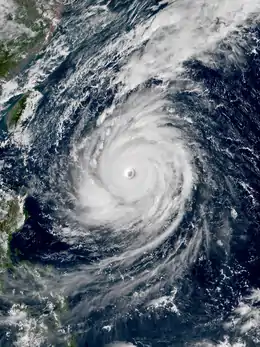
 Typhoon Trami at peak intensity south of Okinawa on September 25 | |
| Formed | September 20, 2018 |
| Dissipated | October 8, 2018 |
| (Extratropical after October 1) | |
| Highest winds | 10-minute sustained: 195 km/h (120 mph) 1-minute sustained: 260 km/h (160 mph) |
| Lowest pressure | 915 hPa (mbar); 27.02 inHg |
| Fatalities | 4 total |
| Damage | $2.69 billion (2018 USD) |
| Areas affected | Mariana Islands, Taiwan, Japan, Russian Far East, Alaska |
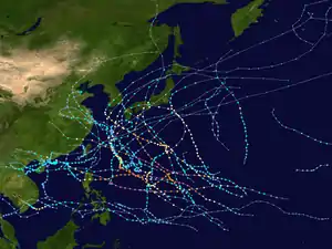
| Part of the 2018 Pacific typhoon season | |
Trami caused additional damage to Japan, while it still recovering from the impacts of Typhoon Jebi. Transportation was disrupted with several domestic flights were cancelled. Over 380,000 people were evacuated. In total, Trami killed 4 people and left hundreds of injures. Insurance loss were estimated to be ¥306 billion (2018 JPY, $2.69 billion USD).
Meteorological history

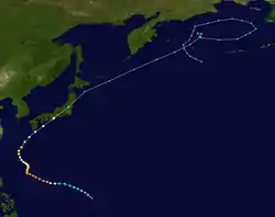
On September 20, the Japan Meteorological Agency (JMA) began to track a tropical depression located to the southeast of Guam.[1] Moving northwestward, the depression gained some organization, and the Joint Typhoon Warning Center (JTWC) issued a Tropical Cyclone Formation Alert (TCFA),[2] and classified the system as a tropical depression later that day, giving the numeral designation 28W.[3] The JMA started issuing advisories once the system attained winds of 55 km/h (30 mph).[4] The JTWC upgraded 28W to a tropical storm on September 21, as it became better organized.[5] The JMA followed suit later that day, assigning the international name Trami.[6]
The system moved west-northwestward on September 22, under the influence of a subtropical ridge to its north. Benefited from the favourable condition such as high sea surface temperatures (SSTs) of 28 °C (82 °F) and low wind shear, Trami gradually intensified, attaining severe tropical storm on the morning,[7] and became the tenth typhoon of the annual typhoon season later that day.[8] The JTWC followed suit three hours later.[9] Continued moving west-northwestward, Trami kept on intensifying thanks to favourable environmental condition. It developed a pinhole eye on that day,[10] but soon entered a period of eyewall replacement cycle. Trami completed this cycle early on September 24 and resumed its intensification, with its eye became larger.[11] According to JMA, the storm achieved its peak intensity at 18:00 UTC that day, with 10-minute maximum sustained winds of 195 km/h (120 mph), and a central pressure of 915 hPa (mbar; 27.02 inHg). The JTWC said that Trami has become a Category 5-equivalent super typhoon three hours later, with 1-minute sustained winds of 260 km/h (160 mph).[12]
Soon afterwards, Trami lost its steering current and slowed as it is situated between two subtropical high pressure,[13] an area called the pressure field of the saddle type.[14] The typhoon's persistence over the same location for several days resulted in tremendous upwelling of cooler waters, with sea surface temperatures dropping from 28 to 21 °C (82 to 70 °F).[15] The combined effect of cooler water and dry air resulted in significant weakening, and Trami dropping below super typhoon status late on September 25.[16] However, the previously small eye of Trami expanded dramatically.[17] On September 28, the subtropical ridge over the Pacific Ocean slightly intensified, and Trami accelerated to the northwest.[18] Trami turned to the northeast along a westerlies on September 29,[19] and passed just west of the Okinawa Island.[20] The typhoon made landfall near Tanabe, Wakayama at 8:00 p.m. JST on September 30 (11:00 UTC), with winds of 150 km/h (90 mph).[21] After Trami impacted Honshu, it completely transitioned into a hurricane-force extratropical cyclone and impacted the Kuril Islands and weakened to a storm-force system. Its extratropical remnants were last tracked in the Bering Sea, near the Aleutian Islands.
Impact
Taiwan
On September 28, the Central Weather Bureau (CWB) issued the heavy rain and extremely heavy rain alert to 7 cities and counties of Taiwan, warned that the rainfall in 24 hours will reach 200 mm (7.9 in) in those alerted area.[22] The CWB also warned that the coastal and open areas may be affected by winds of Beaufort scale 9–11.[23] Although Taiwan avoided a direct hit from Trami, large waves still affected the northern Taiwan. Wave heights at 4 m (13 ft) were recorded, and 4 people were injured by the large surf.[24]
Japan

Trami made its closest approach to the Okinawa Island in the afternoon of September 29, passing just 30 km (19 mi) west of the Naha Airport.[20] Wind gusts reached 50.8 m/s (183 km/h) in Naha, Okinawa.[25] 50 people were injured, and about 600 people were evacuated to the shelters.[26] 30 cities and towns in Okinawa were suffering power outage.[27] Almost 200 flights to the prefecture were cancelled.[28] A guanyin statue in Ryukyu Golden Palace collapsed, estimated loss of about ¥100 million (US$880,000).[29]
Trami brought strong winds and waves to Japan. The typhoon broke the historical records of 10-minute maximum sustained winds at 30 weather stations and the maximum gust at 55 weather stations in Japan, mostly on September 30. In mainland Japan, the maximum gust from Trami were recorded at Hachioji, Tokyo, of 45.6 metres per second (164 km/h), which broke the record set in 2011. Trami also produced storm surge of 11.71 m (38.4 ft) at Cape Irōzaki.[30] More than 1,000 flights in Japan were cancelled, including 45 from Hong Kong.[31] At least 4 deaths and more than 200 injuries were reported across the country.[26] Insurance loss were estimated to be ¥306.1 billion (US$2.69 billion).[32]
See also
References
- "WWJP25 RJTD 200000 WARNING AND SUMMARY 200000". Japan Meteorological Agency. September 20, 2018. Archived from the original on September 21, 2018. Retrieved September 21, 2018.
- "Tropical Cyclone Formation Alert". Joint Typhoon Warning Center. September 20, 2018. Archived from the original on September 21, 2018. Retrieved September 21, 2018.
- "Tropical Depression 28W (Twenty-eight) Warning Nr. 1". Joint Typhoon Warning Center. September 20, 2018. Archived from the original on September 21, 2018. Retrieved September 21, 2018.
- "RSMC Tropical Cyclone Advisory". Japan Meteorological Agency. September 20, 2018. Archived from the original on September 21, 2018. Retrieved September 21, 2018.
- "Tropical Storm 28W (Twenty-eight) Warning Nr. 3". Joint Typhoon Warning Center. September 21, 2018. Archived from the original on September 22, 2018. Retrieved September 22, 2018.
- "RSMC Tropical Cyclone Advisory". Japan Meteorological Agency. September 21, 2018. Archived from the original on September 22, 2018. Retrieved September 22, 2018.
- "RSMC Tropical Cyclone Advisory". Japan Meteorological Agency. September 22, 2018. Archived from the original on September 22, 2018. Retrieved September 22, 2018.
- "RSMC Tropical Cyclone Advisory". Japan Meteorological Agency. September 22, 2018. Archived from the original on September 23, 2018. Retrieved September 23, 2018.
- "Typhoon 28W (Twenty-eight) Warning Nr. 9". Joint Typhoon Warning Center. September 22, 2018. Archived from the original on September 23, 2018. Retrieved September 23, 2018.
- "這隻真的要注意一下!中颱「潭美」將開眼 2天後恐成強颱" (in Chinese). SET News. September 23, 2018. Retrieved September 23, 2018.
- 李鴻典 (September 24, 2018). "潭美颱風眼變大了!台灣能否再躲過一次?" (in Chinese). SET News. Retrieved September 24, 2018.
- "Super Typhoon 28W (Twenty-eight) Warning Nr. 17". Joint Typhoon Warning Center. September 24, 2018. Archived from the original on September 25, 2018. Retrieved September 25, 2018.
- "強颱潭美陷「鞍型場」!時速5km原地打轉 龜速飄移2天等高壓" (in Chinese). ETtoday. September 25, 2018. Retrieved September 25, 2018.
- 張泉湧 (2015). 圖解大氣科學 (in Chinese). Wu-Nan Book Inc. p. 63. ISBN 957118330X. Retrieved September 25, 2018.
- "潭美滯留、打轉的傑作." Facebook (in Chinese). Taiwan Typhoon BBS. September 26, 2018. Retrieved September 26, 2018.
- "Typhoon 28W (Twenty-eight) Warning Nr. 21". Joint Typhoon Warning Center. September 25, 2018. Archived from the original on September 26, 2018. Retrieved September 26, 2018.
- 方佳琳 (September 26, 2018). "潭美減弱凋零 專家警告:底子夠好有機會再「長回來」" (in Chinese). TVBS. Retrieved September 26, 2018.
- "「特別的狀態」潭美原地打轉3天 鄭明典:終於要動了" (in Chinese). SET News. September 28, 2018. Retrieved September 28, 2018.
- 吳德榮 (September 28, 2018). "老大洩天機/潭美加速「變性」!北東山區防大雨" (in Chinese). SET News. Retrieved September 28, 2018.
- 張嘉敏 (September 29, 2018). "【颱風潭美.直擊】沖繩狂風暴雨酒店停水電 遊日港人摸黑捱杯麵" (in Chinese). HK01. Retrieved September 29, 2018.
- "平成30年 台風第24号に関する情報 第101号" (in Japanese). Japan Meteorological Agency. September 30, 2018. Archived from the original on September 30, 2018. Retrieved September 30, 2018.
- "潭美今明最接近台灣 北台灣豪大雨特報" (in Chinese). Liberty Times. September 28, 2018. Archived from the original on September 29, 2018. Retrieved September 29, 2018.
- "潭美風場影響! 北北基大雨特報、19縣市慎防強風" (in Chinese). Liberty Times. September 27, 2018. Retrieved September 27, 2018.
- 陳崇翰 (September 30, 2018). "潭美環流影響 八斗子掀4米巨浪傷人" (in Chinese). FTV News. Retrieved October 1, 2018.
- "台風24号:那覇で瞬間50.8メートル 暴風さらに強まる恐れ" (in Japanese). Okinawa Times. September 29, 2018. Retrieved September 29, 2018.
- 平成30年台風第24号による被害及び 消防機関等の対応状況(第9報) (pdf) (Report) (in Japanese). Fire and Disaster Management Agency. October 12, 2018. Retrieved October 13, 2018.
- Barnett, Helen (September 29, 2018). "Typhoon Trami hits Japan cutting power in 30 TOWNS as it nears Tokyo seeing hundreds flee". Daily Express. Retrieved September 29, 2018.
- Robinson, Matthew (September 28, 2018). "Typhoon Trami WARNING: 200 flights CANCELLED as devastating storm approaches Japan". Daily Express. Retrieved September 28, 2018.
- "台風24号で高さ25メートル重さ40トンの巨大観音菩薩、倒れる" (in Japanese). Ryūkyū Shimpō. September 30, 2018. Retrieved September 30, 2018.
- 台風第24号による暴風・高潮等 (pdf) (Report) (in Japanese). Japan Meteorological Agency. October 11, 2018. Retrieved October 12, 2018.
- Kao, Ernest (October 1, 2018). "Typhoon Trami leaves at least 45 flights between Hong Kong and Japan cancelled or delayed". South China Morning Post. Retrieved October 1, 2018.
- "自然災害保険金、過去最高の1.6兆円支払い 値上げへ". Asahi Shimbun. May 21, 2019. Retrieved May 25, 2019.
External links
| Wikimedia Commons has media related to Typhoon Trami (2018). |
- JMA General Information of Typhoon Trami (1824) from Digital Typhoon
- JMA Best Track Data of Typhoon Trami (1802) (in Japanese)
- 28W.TRAMI from the U.S. Naval Research Laboratory
