West Beckwith Mountain
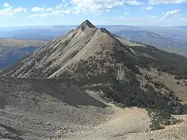
West Beckwith Mountain is a prominent mountain summit in the West Elk Mountains range of the Rocky Mountains of North America. The 12,185-foot (3,714 m) peak is located in the West Elk Wilderness of Gunnison National Forest, about 16.5 miles (26.5 km) southwest of Crested Butte in Gunnison County, Colorado, United States.[2][1]
| West Beckwith Mountain | |
|---|---|
| West Beckwith Peak | |
 West Beckwith Mountain viewed from the southeast. | |
| Highest point | |
| Elevation | 12,185 ft (3,714 m) [1] |
| Prominence | 1,465 ft (447 m) [1] |
| Isolation | 1.8 mi (2.9 km) [1] |
| Coordinates | 38°51′35″N 107°16′27″W [2] |
| Geography | |
 West Beckwith Mountain | |
| Location | Gunnison County, Colorado, US[2] |
| Parent range | West Elk Mountains[1] |
| Topo map | USGS 7.5' topographic map West Beckwith Mountain, Colorado[1] |
| Climbing | |
| Easiest route | hike |
West Beckwith Mountain is a laccolith, formed when magma intruded into Mancos Shale some 30 million years ago. Since then, erosion has removed the softer, overlying sedimentary rock, exposing the more resistant igneous rock. West Beckwith Mountain is one of over a dozen laccoliths in the West Elk and adjacent Elk Mountains.[3][4]
Historical names
- West Beckwith Peak[2]
References
- "West Beckwith Peak, Colorado". Peakbagger.com. Retrieved July 31, 2019.
- "West Beckwith Mountain". Geographic Names Information System. United States Geological Survey. Retrieved July 31, 2019.
- Prather, Thomas (1999). Geology of the Gunnison Country (2nd ed.). Gunnison, Colorado: B&B Printers. LCCN 82-177244.
- "Geologic Road Log of Kebler Pass" (PDF). United States Forest Service. Archived from the original (PDF) on February 23, 2017. Retrieved April 12, 2020.
External links
- "West Beckwith Mountain". Lists of John.
This article is issued from Wikipedia. The text is licensed under Creative Commons - Attribution - Sharealike. Additional terms may apply for the media files.
