Wurtulla, Queensland
Wurtulla is a coastal suburb of Kawana Waters in the Sunshine Coast Region, Queensland, Australia.[2] In the 2016 census, Wurtulla had a population of 5,905 people.[1]
| Wurtulla Kawana Waters, Queensland | |||||||||||||||
|---|---|---|---|---|---|---|---|---|---|---|---|---|---|---|---|
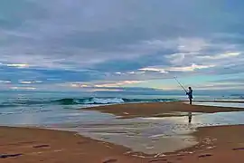
 Fisherman at Dawn, Wurtulla Beach, 2012 | |||||||||||||||
 Wurtulla | |||||||||||||||
| Coordinates | 26.7555°S 153.1266°E | ||||||||||||||
| Population | 5,905 (2016 census)[1] | ||||||||||||||
| • Density | 1,737/km2 (4,500/sq mi) | ||||||||||||||
| Postcode(s) | 4575 | ||||||||||||||
| Area | 3.4 km2 (1.3 sq mi) | ||||||||||||||
| Time zone | AEST (UTC+10:00) | ||||||||||||||
| Location |
| ||||||||||||||
| LGA(s) | Sunshine Coast Region | ||||||||||||||
| County | Canning | ||||||||||||||
| Parish | Bribie | ||||||||||||||
| State electorate(s) | Kawana | ||||||||||||||
| Federal Division(s) | Fisher | ||||||||||||||
| |||||||||||||||
Geography
Wurtulla is located within the Kawana Waters urban centre.
Wurtulla is bounded by the Coral Sea to the east, Currimundi Creek (also known as Currimundi Lake) to the south, Pangali Canal and Lake Kawana to the west and Lake Kawana Boulevarde and Wurley Drive to the north.[3]
The Nicklin Way passes through the suburb from north (Bokarina) to south (Currimundi).[3]
Currimundi Lake (Kathleen McArthur) Conservation Park is a protected area in the south-east of the locality of natural bushland, predominantly the wallum heath that was once commonplace in the coastal areas of South-East Queensland.[3][4]
History
Wurtulla was originally named as a town by Queensland Place Names Board on 1 September 1967 using a name suggested by the developer Alfred Grant Pty Ltd on 31 March 1960. The name is an Aboriginal word meaning southward. It was gazetted as a suburb and bounded on 8 July 1989.[2]
In the 2016 census, Wurtulla had a population of 5,905 people.[1]
Education
There are no schools in Wurtulla. The nearest primary schools are Kawana Waters State College in neighbouring Bokarina to the north and Talara Primary College in neighbouring Currimundi to the south. The nearest secondary school is Kawana Waters State College in Bokarina.[3]
References
- Australian Bureau of Statistics (27 June 2017). "Wurtulla (SSC)". 2016 Census QuickStats. Retrieved 20 October 2018.

- "Wurtulla – suburb in Sunshine Coast Region (entry 48949)". Queensland Place Names. Queensland Government. Retrieved 19 September 2020.
- "Queensland Globe". State of Queensland. Retrieved 13 October 2020.
- "Currimundi Lake (Kathleen McArthur) Conservation Park". Department of Environment and Science. Queensland Government. 21 October 2009. Archived from the original on 13 October 2020. Retrieved 13 October 2020.
External links
| Wikimedia Commons has media related to Wurtulla, Queensland. |
- "Wurtulla". Queensland Places. Centre for the Government of Queensland, University of Queensland.