Yavorivskyi National Park
Yavorivskyi National Park is located in the Ukrainian Roztocze, one of the most interesting physiographic regions of Western Ukraine. Ukrainian Roztocze is a narrow (average 25 km (16 mi)) range of hills 75 km (47 mi) long, which rises sharply to the north of the Lesser Polissya. In the southeastern part of it the main European watershed, on the slopes of which originate river belonging to the basins of two seas - the Black Sea and the Baltic.
| Yavorivskyi National Park | |
|---|---|
IUCN category II (national park) | |
 Yavorivskyi National Park | |
 Map of Ukraine | |
| Location | Western Ukraine |
| Coordinates | 49.981°N 23.732°E[1] |
| Area | 7,108 ha (17,560 acres) |
| Established | 1996 |
| Website | http://yavorpark.in.ua/ |
History
The park was established July 4, 1998, by the President of Ukraine on the base of Yavorivskyi Regional Landscape Park (which existed here since 1996 in the area of 4,190 hectares (10,400 acres)) and surrounding areas Starychivskoho Maherivskoho military and forestry enterprises. The total area of the national park is 7,108 hectares (17,560 acres), of which 2,915 ha (7,200 acres) park provided for permanent use, and 4,193 ha (10,360 acres) incorporated into its structure without removal from the land. In the institution has 44 people, including the scientific division - 4, in the service of - 16 people.

Climate
The climate of the area is typical for Roztocze that is located in the boundary zone of influence of Atlantic air currents from the west and continental - from the east. Overall climate is moderately humid. Average annual rainfall is 700 mm (28 in) and the average temperature - 7.5 °C (45.5 °F). The most rainfall in June and July, and the lowest - in January and February. The hottest month - July (17.7 °C (63.9 °F)) and the coldest - January (−4.2 °C (24.4 °F)). Annual temperature fluctuations are small and reaches 21.9 °C (71.4 °F).
Geography
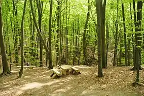
For Yavorivskyi National Park as a whole for Roztocze characterized by high forest cover. Here most common hornbeam-oak and pine-oak and pine forests, and in depressions - alder. Beech forests grow near the Eastern border of the range and are confined to the hilly landscape. Interesting island surviving pockets of spruce, fir and sycamore, which remained on the northeastern limit of its range. By the middle Holocene relicts are beech and pine forests. Herbaceous vegetation occupies a much smaller area and formed by natural meadows and areas of former pastures and settlements, as well as along rivers and channels. Due to favorable natural conditions National Park also has considerable recreational potential and is an interesting tourist destination.[3]
References
- "Yavorivskyi National Park". protectedplanet.net.
- "Yavorivskyi National Park". protectedplanet.net.
- http://ukrainaincognita.com/lvivska-oblast/yavorivskyi-raion/ivano-frankove/yavorivskyi-natsionalnyi-pryrodnyi-park
| Wikimedia Commons has media related to Yavorivskyi National Nature Park. |
