Étréchy, Cher
Étréchy is a commune in the Cher department in the Centre-Val de Loire region of France.
Étréchy | |
|---|---|
Location of Étréchy 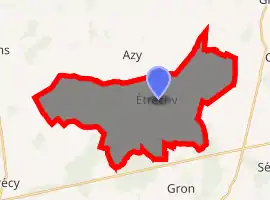
| |
 Étréchy  Étréchy | |
| Coordinates: 47°09′47″N 2°43′33″E | |
| Country | France |
| Region | Centre-Val de Loire |
| Department | Cher |
| Arrondissement | Bourges |
| Canton | Avord |
| Intercommunality | CC La Septaine |
| Government | |
| • Mayor (2008–2014) | Pierre Sarreau |
| Area 1 | 31.88 km2 (12.31 sq mi) |
| Population | 456 |
| • Density | 14/km2 (37/sq mi) |
| Time zone | UTC+01:00 (CET) |
| • Summer (DST) | UTC+02:00 (CEST) |
| INSEE/Postal code | 18090 /18800 |
| Elevation | 171–254 m (561–833 ft) (avg. 205 m or 673 ft) |
| 1 French Land Register data, which excludes lakes, ponds, glaciers > 1 km2 (0.386 sq mi or 247 acres) and river estuaries. | |
Geography
A farming area consisting of the village and a couple of hamlets situated some 15 miles (24 km) northeast of Bourges, at the junction of the D158 with the D52, D36 and D93 roads.
Population
| Year | Pop. | ±% |
|---|---|---|
| 1962 | 595 | — |
| 1968 | 596 | +0.2% |
| 1975 | 487 | −18.3% |
| 1982 | 448 | −8.0% |
| 1990 | 453 | +1.1% |
| 1999 | 419 | −7.5% |
| 2008 | 425 | +1.4% |
Sights
- The church of St. Germain, dating from the thirteenth century.
- The chateau of Astilly, dating from the fifteenth century.
See also
References
- "Populations légales 2017". INSEE. Retrieved 6 January 2020.
| Wikimedia Commons has media related to Étréchy (Cher). |
This article is issued from Wikipedia. The text is licensed under Creative Commons - Attribution - Sharealike. Additional terms may apply for the media files.