Connecticut panhandle
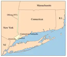
The Connecticut panhandle is the southwestern appendage of Connecticut, where it abuts New York State. It is contained entirely in Fairfield County and includes all of Greenwich, Stamford, New Canaan, and Darien,[1] as well as parts of Norwalk and Wilton. It has some of the most expensive residential real estate in the United States.


.png.webp)
The irregularity in the boundary is the result of territorial disputes in the late 17th century, culminating with New York giving up its claim to this area, whose residents considered themselves part of Connecticut. In exchange, New York received an equivalent area extending northwards from Ridgefield, Connecticut, to the Massachusetts border, as well as undisputed claim to Rye, New York.[2]
The two British colonies negotiated an agreement on November 28, 1683, establishing the New York–Connecticut border as 20 miles (32 km) east of the Hudson River, north to Massachusetts. The 61,660 acres (249.5 km2) east of the Byram River making up the Connecticut panhandle were granted to Connecticut, in recognition of the wishes of the residents. In exchange, Rye was granted to New York, along with a 1.81-mile (2.91 km) wide strip of land known as the "Oblong" running north from Ridgefield to Massachusetts, alongside the New York counties of Westchester, Putnam, and Dutchess.[3][4][5][6]
References
- Frank R. Abate (2001). Connecticut Trivia. Thomas Nelson Inc. p. 19. ISBN 9781558539259.
- Mark Stein (2008). How the States Got Their Shapes. HarperCollins. pp. 198–199. ISBN 9780061431395.
- "Surveying Connecticut's Borders | ConnecticutHistory.org". connecticuthistory.org. Retrieved 2018-07-19.
- "CT-NY-MA Tri-Point". www.ctmq.org. Retrieved 2018-07-19.
- "The Oblong in Pawling: A History of a Quaker Hill Community in the Hudson Valley". Retrieved 2018-07-19.
- "About Town: The Oblong | The Ridgefield Press". The Ridgefield Press. 2016-09-06. Archived from the original on 2018-07-19. Retrieved 2018-07-19.
