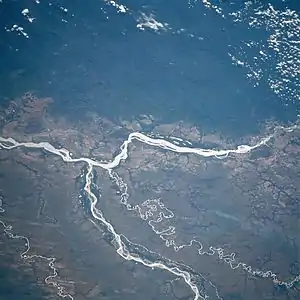
Deforestation by region
Rates and causes of deforestation vary from region to region around the world. In 2009, 2/3 of the world forests were in 10 top countries: 1) Russia, 2) Brazil, 3) Canada, 4) United States, 5) China, 6) Australia, 7) Congo, 8) Indonesia, 9) Peru and 10) India.[1]
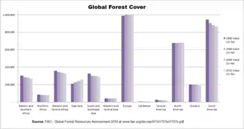
World annual deforestation is estimated as 13.7 million hectares a year, equal to the area of Greece. Only half of this area is compensated by new forests or forest growth. In addition to directly human-induced deforestation, the growing forests have also been affected by climate change, increasing risks of storms, and diseases. Kyoto protocol includes the agreement to prevent deforestation but not the actions to fulfill it.[1]
Africa
As of 2008, Africa is suffering deforestation at twice the world rate, according to the United Nations Environment Programme (UNEP).[2][3][4] Some sources claim that deforestation has already wiped out roughly 90% of West Africa's original forests.[5][6] Deforestation is accelerating in Central Africa.[7] According to the FAO, Africa lost the highest percentage of tropical forests of any continent during the 1980s, 1990s, and early 2000s.[8] According to the figures from the FAO (1997), only 22.8% of West Africa's moist forests remain, much of this degraded.[9] Nigeria has lost 81% of its old-growth forests in just 15 years (1990–2005).[10] Massive deforestation threatens food security in some African countries.[11] One factor contributing to the continent's high rates of deforestation is the dependence of 90% of its population on wood as fuel for heating and cooking.[12]
Research carried out by WWF International in 2006 shows that in Africa, rates of illegal logging vary from 50% in Cameroon and Equatorial Guinea to 70% in Gabon and 80% in Liberia[13] – where timber revenues played a major role in financing the Sierra Leone Civil War[14] and other regional armed conflicts until the UN Security Council imposed a ban on all Liberian timber in 2003.[15]
Democratic Republic of the Congo
Deforestation in the Democratic Republic of the Congo has been caused partly by unregulated logging and mining, but mostly by the demands made by the subsistence activities of a poor population. In the east of the country, for example, more than 3 million people live less than a day's walk from Virunga National Park. Wood from the park's forests is used by many of those people as firewood, as lumber for construction, and in the production of charcoal. Deforestation caused by subsistence living is an acute threat to the park in general, and to the habitat of the critically endangered mountain gorilla in particular.[16] From 2014 to 2018 the rate of tree-felling in the Democratic Republic of Congo has doubled.[17][18]
Ethiopia
The main cause of deforestation in the East African country of Ethiopia is a growing population and subsequent higher demand for agriculture, livestock production and fuel wood.[19] Other reasons include low education and inactivity from the government,[20] although the current government has taken some steps to tackle deforestation.[21] Organizations such as Farm Africa are working with the federal and local governments to create a system of forest management.[22] Ethiopia, the third largest country in Africa by population, has been hit by famine many times because of shortages of rain and a depletion of natural resources. Deforestation has lowered the chance of getting rain, which is already low, and thus causes erosion. Bercele Bayisa, an Ethiopian farmer, offers one example why deforestation occurs. He said that his district was forested and full of wildlife, but that overpopulation caused people to come to that land and clear it to plant crops, cutting all trees to sell as firewood.[23]
Ethiopia has lost 98% of its forested regions in the last 50 years.[22] At the beginning of the 20th century, around 420,000 km2 or 35% of Ethiopia's land was covered with forests. Recent reports indicate that forests cover less than 14.2%[22] or even only 11.9% as of 2005.[24] Between 1990 and 2005, the country lost 14% of its forests or 21,000 km2.
Kenya
In 1963 Kenya had forest cover of some 10 percent; by 2006 it had only 1.7 percent.[25]
Madagascar
Deforestation[26] with resulting desertification, water resource degradation and soil loss has affected approximately 94% of Madagascar's previously biologically productive lands. Since the arrival of humans 2000 years ago, Madagascar has lost more than 90% of its original forest.[27] Most of this loss has occurred since independence from the French, and is the result of local people using slash-and-burn agricultural practices as they try to subsist.[28] Largely due to deforestation, the country is currently unable to provide adequate food, fresh water and sanitation for its fast growing population.[29][30]
Nigeria
According to the FAO, Nigeria has the world's highest deforestation rate of primary forests. It has lost more than half of its primary forest in the last five years. Causes cited are logging, subsistence agriculture, and the collection of fuel wood. Almost 90% of West Africa's rainforest has been destroyed.[31]
Asia
Russia
Russia has the largest area of forests of any country on Earth, with around 12 million km2 of boreal forest, larger than the Amazon rainforest. Russia's forests contain 55% of the world's conifers and represent 11% of biomass on Earth. It is estimated that 20,000 km2 are deforested each year.[32] The present scale of deforestation in Russia is most easily seen using Google Earth. Areas nearer to China are most affected, as it is the main for the timber.[33] Deforestation in Russia is particularly damaging as the forests have a short growing season due to extremely cold winters and therefore will take longer to recover.
Southeast Asia
Forest loss is acute in Southeast Asia,[34] the second of the world's great biodiversity hot spots.[35] According to a 2005 report conducted by the FAO, Vietnam has the second highest rate of deforestation of primary forests in the world, second to only Nigeria.[36] More than 90% of the old-growth rainforests of the Philippine Archipelago have been cut.[37] Other Southeast Asian countries where major deforestation is ongoing are Cambodia and Laos. According to a documentary by TelePool, the deforestation is being directed by corrupt military personnel and government (forestry services).[38]
Cambodia


Cambodia is one of the world's most forest endowed countries that has not yet been drastically deforested. However, massive deforestation for economic development threatens its forests and ecosystems. As of 2015, the country has one of the highest rates of deforestation in the world.[39]
Deforestation has directly resulted from poorly managed commercial logging, fuel wood collection, agricultural invasion, and infrastructure and urban development. Indirect pressures include rapid population growth, inequalities in land tenure, lack of agriculture technology, and limited employment opportunities.[40]
The Cambodian government has played a large role in shaping the use of the country's forests. An unusually large area of Cambodia has been designated as protected areas and biodiversity corridors, over 38% (more than 7 million hectares) of the total land mass,[41] but many protections have subsequently been overruled by concessions sold to both national and foreign companies for agroindustrial plantations and mining developments, even in national parks. The government has been broadly criticized domestically and internationally for these contradicting policies, and a general lack of enforcement of environmental laws. They have faced pressures to practice a more sustainable forestry overall. The fate of Cambodia's forests will largely affect local communities that rely on the forests for their livelihood. Around 80% of its population lives in rural areas.[42]
Cambodia's primary forest cover fell dramatically from over 70% in 1970 at the end of the Vietnam War to just 3.1% in 2007, when less than 3,220 square kilometers of primary forest remained.[43] Deforestation is proceeding at an alarming rate: nearly 75% of forest loss has occurred since the end of 1990s. In total, Cambodia lost 25,000 square kilometers of forest between 1990 and 2005, 3,340 square kilometer of which was primary forest.[43] As 2016, 87,424 square kilometers of forest remained including 28, 612 square kilometers of evergreen forest,[44] with the result that the future sustainability of Cambodia's forest reserves is under severe threat.[45]Indonesia
As of 2008, at present rates, tropical rainforests in Indonesia would be logged out in 10 years, Papua New Guinea in 13 to 16 years.[46]
Indonesia had lost over 72% of intact forests and 40% of all forests completely in 2005.[47] Illegal logging took place in 37 out of 41 national parks. The illegal logging costs up to US$4 billion a year. The lowland forests of Sumatra and Borneo were at risk of being wiped out by 2022. According to Transparency International, numerous controversial court decisions in this area have raised concerns about the integrity of the judiciary.[48]
Malaysia
Philippines
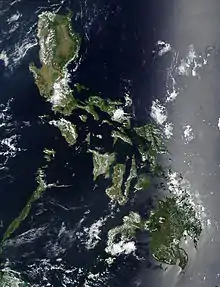
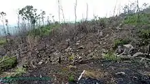
Along with other Southeast Asian countries deforestation in the Philippines is a major environmental issue. Over the course of the 20th century, the forest cover of the country dropped from 70 percent down to 20 percent.[50] Based on an analysis of land use pattern maps and a road map an estimated 9.8 million hectares of forests were lost in the Philippines from 1934 to 1988.[51]
A 2010 land cover mapping by the National Mapping and Resource Information Authority (NAMRIA) revealed that the total forest cover of the Philippines is 6,839,718 hectares (68,397.18 km2) or 23% of the country's total area of 30,000,000 hectares (300,000 km2).[52]Thailand

Deforestation in Thailand refers to the conversion of its forested land to other uses. Deforestation numbers are inexact due to the scope of the issue. According to the Royal Forest Department (RFD) in 2019, Thai forests cover 31.6% (102 million rai) of Thailand's landmass.[53] The department claims that forest coverage grew by 330,000 rai in 2018, an area equivalent in size to the island of Phuket.[54] A year earlier, an academic claimed that, since 2016, forested area has declined by 18,000 rai, a significant improvement over the period 2008–2013, when a forested million rai were lost each year.[55] In 1975, the government set a goal of 40% forest coverage—25% natural forest and 15% commercial forest—within 20 years. To achieve that target in 2018, 27 million rai would have to be afforested.[55]
Between 1945 and 1975, forest cover in Thailand declined from 61% to 34% of the country's land area. Over the succeeding 11 years, Thailand lost close to 28% of all of its remaining forests. This means that the country lost 3.1% of its forest cover each year over that period. An estimate by the World Wildlife Fund concluded that between 1973 and 2009, 43% of forest loss in the Greater Mekong subregion occurred in Thailand and Vietnam.[56] The Thai Highlands in northern Thailand, the most heavily forested region of the country, were not subject to central government control and settlement until the second half of the 19th century when British timber firms, notably the Bombay Burmah Trading Corporation and the Borneo Company Limited, entered the teak trade in the late-1880s and early-1890s.[57] The Royal Forest Department, created in 1896 and headed by a British forester until 1925, sought to conserve the forests against the worst business practices of British, Thai, and Chinese timber firms who worked in the region.
During the 20th century, deforestation in Thailand was driven primarily by agricultural expansion,[58] although teak deforestation happened as a direct result of logging. Much of Thailand's recent economic improvement can be attributed to increased agricultural production for export. The country was able to increase production by clearing much of their forest and converting it to cropland.
The Thai government is beginning to emphasize forest restoration.[59]Vietnam
According to a 2005 report conducted by the Food and Agriculture Organization of the United Nations (FAO), Vietnam has the second highest rate of deforestation of primary forests in the world, second only to Nigeria.[60]
However, regarding total forest cover, Vietnam has undergone a forest transition: its forest cover has increased since the early 1990s, after decades of deforestation.[61]
As of 2005, 12,931,000 hectares (the equivalent of 39.7% of Vietnam's land cover) was forested, although only 85,000 hectares (0.7% of the land cover) was primary forest, the most biodiverse form of forest.[62]
Vietnam has some 1,534 known species of fauna and 10,500 species of vascular plants, according to the World Conservation Monitoring Centre. 3.4% of Vietnam is protected under IUCN categories I-V.
Large areas of Vietnam were deforested during the Vietnam War due to the use of Agent Orange.Japan
Yoichi Kuroda sketches a history and current outline of 'large scale land and landscape destruction' here See also Mudslides and Erosion.
Sri Lanka
Europe
Europe has lost more than half of its forests in the past 6,000 years. This has primarily been due to agricultural expansion and demand for wood fuel.[66] According to satellite data, the loss of biomass in EU’s forests increased by 69% in the period from 2016 to 2018, compared with the period from 2011 to 2015.[67]

Finland
Iceland
Iceland has undergone extensive deforestation since Scandinavians settled in the ninth century. At the time of human settlement about 1140 years ago, birch forest and woodland covered 'at least 25%' of Iceland's land area. The settlers began by cutting down the forests and burning scrubland to create fields and grazing land. Deforestation did not end in Iceland until the middle of the 20th century. Afforestation and revegetation has restored small areas of land.[69] However, agriculture was the main reason birch forest and woodland did not grow back.
Italy
Sicily is an oft-cited example of man-made deforestation, practiced since Roman times, when the island was made an agricultural region,[70] and continued to this day. This gradually aridified the climate, leading to decline of rainfall and drying of rivers. Today, the entire central and southwest provinces are practically without any forests.[71] This has also affected Sicily's wild fauna, of which little is left in the island's pastures and crop fields.[70]
Russia
North America
Canada
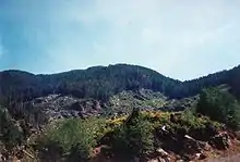
In 2005, an estimated 56,000 hectares were deforested in Canada. Deforestation affected less than 0.02% of Canada’s forests in 2005. The agricultural sector accounted for just over half of the deforestation in 2005, the result of forests having been cleared for pasture or crops. The remainder was caused by urban development, transportation corridors, and recreation (19%); hydroelectric development (10%); the forest sector (10%); and other natural resource extraction industries (8%). About two thirds of this deforestation occurred in Canada’s boreal forest, mainly in Alberta, Saskatchewan, and Manitoba where the forest borders the Prairies. [72]
In Canada, prior to 2000, less than 8% of the boreal forest was protected from development and more than 50% has been allocated to logging companies for cutting.[73]
British Columbia
United States

In 1600, prior to the arrival of European-Americans, roughly half of the land area of the present-day United States was forest—about 4,000,000 square kilometres (990,000,000 acres). For the next 300 years land was cleared, mostly for agriculture, at a rate that matched the rate of population growth. For every person added to the population, one to two hectares of land was cultivated. This trend continued until the 1920s when the amount of crop land stabilized in spite of continued population growth. As abandoned farmland reverted to forest, the amount of forestland increased from 1952, reaching a peak in 1963 of 3,080,000 square kilometres (760,000,000 acres). Since 1963 there has been a steady decrease of forest area with the exception of some gains from 1997.
Central America and the Caribbean
The history of most Central American countries involves cycles of deforestation and reforestation. By the fifteenth century, intensive Mayan agriculture had significantly thinned the forests. Before Europeans arrived, forests covered 500,000 square kilometers – approximately 90% of the region. Eventually, the forcing of "Europe's money economy on Latin America" created the demand for the exportation of primary products, which introduced the need for large amounts of cleared agricultural land to produce those products.[76] Since the 1960s, cattle ranching has become the primary reason for land clearing. The lean grass-fed cattle produced by Central American ranches (as opposed to grain-fed cattle raised elsewhere) was perfectly suited for American fast-food restaurants and this seemingly bottomless market has created the so-called "hamburger connection" which links "consumer lifestyles in North America with deforestation in Central America".[76]
Haiti

South America
Amazon Rainforest
The Amazon rainforest is the largest rainforest in the world, covering an area of 5,500,000 km2 (2,100,000 sq mi). It represents over half of the planet's rainforests, and comprises the largest and most biodiverse tract of tropical rainforest in the world. This region includes territory belonging to nine nations. The majority of the forest is contained within Brazil, with 60%, followed by Peru with 13%, Colombia with 10%, and with minor amounts in Venezuela, Ecuador, Bolivia, Guyana, Suriname and France (French Guiana).
The cattle sector of the Brazilian Amazon, incentivized by the international beef and leather trades,[78] has been responsible for about 80% of all deforestation in the region,[79][80] or about 14% of the world's total annual deforestation, making it the world's largest single driver of deforestation.[81] The vast majority of agricultural activity resulting in deforestation was subsidized by government tax revenue.[82] By 1995, 70% of formerly forested land in the Amazon, and 91% of land deforested since 1970 had been converted to cattle ranching.[83][84] Much of the remaining deforestation within the Amazon has resulted from farmers clearing land (sometimes using the slash-and-burn method) for small-scale subsistence agriculture[85] or mechanized cropland producing soy, palm, and other crops.[86]
More than one-third of the Amazon forest belongs to more than 3,344 formally acknowledged indigenous territories. Until 2015, only 8% of Amazonian deforestation occurred in forests inhabited by indigenous peoples, while 88% of occurred in the less than 50% of the Amazon area that is neither indigenous territory nor protected area. Historically, the livelihoods of indigenous Amazonian peoples have depended on the forest for food, shelter, water, fibre, fuel and medicines. The forest is also interconnected with their identity and cosmology. For this reason the deforestation rates are lower in indigenous territories, despite pressures encouraging deforestation being stronger.[87]
According to 2018 satellite data compiled by a deforestation monitoring program called Prodes, deforestation has hit its highest rate in a decade. About 7,900 km2 (3,050 sq miles) of the rainforest was destroyed between August 2017 and July 2018. Most of the deforestation occurred in the states of Mato Grosso and Pará. The BBC reported the environment minister, Edson Duarte, as saying illegal logging was to blame, but critics suggest expanding agriculture is also encroaching on the rainforest.[88] It is suggested that at some point the forest will reach a tipping point, where it will no longer be able to produce enough rainfall to sustain itself.[89]Brazil
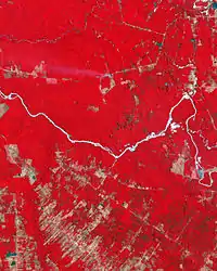
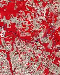
There is no agreement on what drives deforestation in Brazil, though a broad consensus exists that expansion of croplands and pastures is important. Increases in commodity prices may increase the rate of deforestation.[90][91] Recent development of a new variety of soybean has led to the displacement of beef ranches and farms of other crops, which, in turn, move farther into the forest.[92] Certain areas such as the Atlantic Rainforest have been diminished to just 7% of their original size.[93] Although much conservation work has been done, few national parks or reserves are efficiently enforced.[94] Some 80% of logging in the Amazon is illegal.[95]
In 2008, Brazil's government announced a record rate of deforestation in the Amazon.[96][97] Deforestation jumped by 69% in 2008 compared to 2007's twelve months, according to official government data.[98] Deforestation could wipe out or severely damage nearly 60% of the Amazon rainforest by 2030, according to a 2007 report from WWF.[99]
Chile
Despite modern views of Atacama Desert as fully devoid of vegetation in pre-Hispanic and Colonial times a large flatland area known as Pampa del Tamarugal was forested, with demand of firewood associated silver and saltpeter mining causing widespread deforestation. While Tarapacá was still part of Peru demand of firewood by salpeter processing using the paradas method led to widespread deforestation around La Tirana and Canchones plus some areas to the south of these localities.[100] Reforestation effors in Pampa del Tamarugal begun in 1963 and since 1987 reforestated areas are protected in the Pampa del Tamarugal National Reserve.[100]
Colombia
Colombia loses 2,000 km2 of forest annually to deforestation, according to the United Nations in 2003.[101] Some suggest that this figure is as high as 3,000 km² due to illegal logging in the region.[101] Deforestation results mainly from logging for timber, small-scale agricultural ranching, mining, development of energy resources such as hydro-electricity, infrastructure, cocaine production, and farming.[101]
Deforestation in Colombia is mainly targeted at primary rainforest which covers more than 80% of Colombia. This has a profound ecological impact in that Colombia is extremely rich in biodiversity, with 10% of the world's species, making it the second most biologically diverse country on Earth.[101]Peru
Oceania
Australia
Due to relatively recent colonisation, Australia has had high rates of deforestation, primarily due to clearing for agricultural purposes. In recent years much of the clearing has occurred in Tasmania and Queensland.[102] In 2007, rates were expected to decrease with the implementation of new legislation.[103][104] In 1998, deforestation is thought to have been responsible for around 12% of Australia's total carbon emissions.
An additional factor currently causing the loss of forest cover is the expansion of urban areas. Littoral rainforest growing along coastal areas of eastern Australia is now rare due to ribbon development to accommodate the demand for seachange lifestyles.[105]
Vast amounts of logging continue in Australia despite the devastation of the Black Summer Bushfires in 2019–2020.
New Zealand
In the 800 years of human occupation of New Zealand 75% of the forests were lost. Initially it was by wholesale burning by the British but remaining forests were logged for lumber for the burgeoning population. By 2000 all logging of native trees on public land was stopped. Logging on private land is controlled with a permit system and with the Resource Management Act.
Papua New Guinea
Papua New Guinea (PNG) has one of the world’s largest rainforests. Illegal logging was among highest in the world in 2007, estimated as ca 70-90% of all timber export.[106]
See also
- List of conservation issues
- List of environmental issues
- Reducing emissions from deforestation and forest degradation (REDD)
- Indian Council of Forestry Research and Education
References
- Al Gore: Our Choice, A plan to solve the climate crises, Bloomsbury 2009, Chapter 9 Forests 170-195; pages 174, 192, 184, 186, 192, 172
- Nature laid waste: The destruction of Africa, The Independent, June 11, 2008
- Africa's deforestation twice world rate, says atlas, Reuters, June 10, 2008
- Deforestation reaches worrying level - UN Archived 2008-12-06 at the Wayback Machine. AfricaNews.
- Forests and deforestation in Africa - the wasting of an immense resource Archived 2009-05-20 at the Wayback Machine, afrol News
- Nix, Steve (9 July 2019). "The Territory and Current Status of the African Rainforest". ThoughtCo.
- Adelaja, Abiose (June 8, 2007). "Deforestation accelerating in Central Africa". SciDev.Net.
- Africa's deforestation rate may be underestimated. mongabay.com. June 22, 2006.
- Tropical Deforestation Rates in Africa. mongabay.com. Retrieved on May 31, 2009.
- "Nigeria: Environmental Profile". Rainforests.mongabay.com. Retrieved 2010-09-10.
- Raphael Mweninguwe. "Massive deforestation threatens food security". Newsfromafrica.org. Archived from the original on 2011-07-18. Retrieved 2010-09-10.
- Agyei, Yvonne. Deforestation in Sub-Saharan Africa. African Technology Forum, Volume 8, Number 1. Retrieved on May 31, 2009.
- Paul Toyne, Cliona O’Brien and Rod Nelson (2002). "The Timber Footprint of the G8 and China" (PDF). WWF International. p. 35-36. Archived from the original (PDF) on 2017-02-03. Retrieved 2019-05-07.
- Blondel, Alice. "The Logs of War" Archived 2006-11-16 at the Wayback Machine. Monde Diplomatique. January 2004.
- Black, Richard. "New Dawn for Liberia's 'Blood Forests'" Archived 2006-11-16 at the Wayback Machine. BBC News. October 12, 2006.
- These deforesting activities have been amply documented by numerous authors (Accion contra el Hambre, 1999; Biswas & Tortajada-Quiroz, 1996; Fuelwood Crisis Consortium, 1994; Henquin & Blondel, 1996; Lodhi et al., 1998; Blondel, 1997; Leusch, 1995; and Languy, 1995).
- Kinver, Mark (2019-09-12). "World 'losing battle against deforestation'". BBC News.
- Harvey, Fiona (2019-09-12). "Deforestation damage goes far beyond the Amazon". The Guardian.
- Sucoff, E. (2003). "Deforestation". Environmental Encyclopedia. pp. 358-359. Detroit: Gale.
- Mccann, J.C. (1999). Green land, Brown land, Black land: An environmental history of Africa 1800-1990. Portsmouth, NH: Heinemann.
- Maddox, G.H. (2006). Sub-Saharan Africa: An environmental history. Santabarbara, CA: ABC-CLIO.
- Parry, J. (2003).
- Haileselassie, A. Ethiopia's struggle over land reform. World press Review 51.4 (April 2004):32(2). Expanded Academic ASAP
- "Statistics: Ethiopia". Rhett A. Butler, mongabay.com. n.d. Retrieved June 4, 2007.
- Sheila Masinde and Lisa Karanja. "The plunder of Kenya's forests: Resettling the settlers and holding the loggers accountable" (PDF). Global Corruption Report 2011: Climate Change. Transparency International. p. 280-282. Archived from the original (PDF) on 2019-10-16. Retrieved 2019-05-07.
- Saving the Wildlife of Madagascar, TIME, September 25, 2008
- World Wildlife Fund, ed. (2001). "Madagascar subhumid forests". WildWorld Ecoregion Profile. National Geographic Society. Archived from the original on 2010-03-08.
- "Deforestation causes species extinction in Madagascar". News.mongabay.com. Retrieved 2010-09-10.
- "What are rainforests?". Kids.mongabay.com. Retrieved 2010-09-10.
- "Deforestation in Madagascar". American.edu. Retrieved 2010-09-10.
- "Rainforests & Agriculture". Csupomona.edu. Archived from the original on 2012-09-30. Retrieved 2010-09-10.
- Russia’s Boreal Forests Archived 2011-09-17 at the Wayback Machine WWF November 2007
- "China: Exporting deforestation and promoting tree monocultures". World Rainforest Movement. 2001-04-13. Retrieved 2019-05-07.
- "China is black hole of Asia's deforestation", Asia News, March 24, 2016
- SE Asia faces 'catastrophic' extinction rate, BBC News
- "Nigeria has worst deforestation rate, FAO revises figures". News.mongabay.com. 2005-11-17. Retrieved 2010-09-10.
- "The Lost Forest". Fieldmuseum.org. Archived from the original on 2010-12-31. Retrieved 2010-09-10.
- "Die Tropenholz-Mafia – Kriminelle Geschäfte mit dem Regenwald – Telepool, 2008". Youtube.com. 2008-11-08. Retrieved 2010-09-10.
- "Cambodia's Forests Are Disappearing". earthobservatory.nasa.gov. 2017-01-10. Retrieved 2019-12-10.
- Sin, Meng Srun. Forestry in Cambodia: The Dilemma of Development and Preservation. Phnom Penh: n.p., 2014. Print.
- "សម្ព័ន្ធសហភាពសហគមន៍អភិរក្សធនធានធម្មជាតិ នឹងបង្កើតឡើងដើម្បីពង្រឹងការគ្រប់គ្រងធនធានធម្មជាតិនៅកម្ពុជា – ក្រសួងបរិស្ថាន" (in Khmer). Retrieved 2019-12-10.
- "Cambodia | FAO Regional Office for Asia and the Pacific | Food and Agriculture Organization of the United Nations". www.fao.org. Retrieved 2019-12-10.
- "Brief on National Forest Inventory - Cambodia" (PDF). Food and Agriculture Organization of the United Nations. June 2007. Retrieved 2013-06-23.
- Cambodia Forest Cover 2016 (PDF). Cambodia: Ministry of Environment. 2018. p. 21.
- "Logging threatens Cambodian tragedy - UN". Thomson Reuters. March 6, 2003.
- China is black hole of Asia's deforestation, Asia News, 24 March 2008.
- Greenpeace Southeast Asia (March 30, 2009). "Indonesian deforestation factsheet: Indonesia, a great country?" (PDF). Retrieved May 7, 2019.
- Transparency International (September 14, 2009). "Global Corruption Report 2009: Corruption and the Private Sector". transparency.org. p. 264. Retrieved May 7, 2019.
- "Malaysia Forest Information and Data". Rainforests.mongabay.com. Retrieved 19 May 2020.
- Lasco, R. D.; R. D. (2001). "Secondary forests in the Philippines: formation and transformation in the 20th century" (PDF). Journal of Tropical Forest Science. 13 (4): 652–670.
- Liu, D; L Iverson; S Brown (1993). "Rates asind patterns of deforestation in the Philippines: application of geographic information system analysis" (PDF). Forest Ecology and Management. 57 (1–4): 1–16. doi:10.1016/0378-1127(93)90158-J. ISSN 0378-1127.
- "County Report; Philippines" (PDF). Global Forest Resources Assessment 2015. Rome: 4. 2015.
- "Forest area of Thailand, 1973-2018". Royal Forest Department. Retrieved 7 December 2019.
- Yonpiam, Chairith (7 December 2019). "Pareena probe must set a precedent" (Opinion). Bangkok Post. Retrieved 7 December 2019.
- Panyasuppakun, Kornrawee (11 September 2018). "Thailand's green cover in slow decline as 40% goal remains out of reach". The Nation. Retrieved 11 September 2018.
- Living Forests Report, Chapter 5 (PDF). Gland, Switzerland: World Wildlife Fund. 2015. p. 35.
Between 1973 and 2009 forests in the Greater Mekong declined by almost a third: 43 per cent in Vietnam and Thailand; 24 per cent in Lao PDR and Myanmar; and 22 per cent in Cambodia.
- Barton, G.A. and B.M. Bennett. (2010) Forestry as Foreign Policy: Anglo-Siamese Relations and the Origins of Britain's Informal Empire in the Teak Forests of Northern Siam, 1883–1925 34 (1): 65-86
- Delang, C.O. (2002) Deforestation in Northern Thailand: the Result of Hmong Swidden Farming Practices or Thai Development Strategies? Society and Natural Resources 15 (6): 483-501]
- Wipatayotin, Apinya; Theparat, Chatrudee (2012-02-28). "Govt to spend B3bn on forest restoration". Bangkok Post. Retrieved 6 Apr 2015.
- Butler, Rhett A. "Nigeria has worst deforestation rate, FAO revises figures" Archived 2009-06-18 at the Wayback Machine. mongabay.com. November 17, 2005.
- Patrick Meyfroidt, Eric F. Lambin (2008). "Forest transition in Vietnam and its environmental impacts." Global Change Biology 14 (6), pp. 1319–1336.
- "Vietnam Deforestation Rates and Related Forestry Figures" Archived 2008-03-03 at the Wayback Machine. mongabay.com. Retrieved on May 31, 2009.
- "Sri Lanka". MSN Encarta Encyclopedia. Archived from the original on 2009-10-31. Retrieved April 22, 2009.
- "Sri Lanka". www.mongabay.com. Mongabay. Retrieved April 22, 2009.
- "Estimating Deforestation and Forest Degradation in Sri Lanka" (PDF). University of Gothenburg. 25–28 August 2008. Retrieved April 22, 2009.
- "More than half of Europe's forests lost over 6,000 years". Mongabay Environmental News. 2018-01-24. Retrieved 2020-02-03.
- Harvey, Fiona (2020-07-01). "Europe losing forest to harvesting at alarming rate, data suggests". The Guardian. ISSN 0261-3077. Retrieved 2020-07-07.
- Miten päästöt saadaan kuriin Helsingin Sanomat 9.8.2019 A6-A7 (ref The Finnish Climate Change Panel Mr. Markku Ollikainen)
- "LandUse: Why Iceland". Landbunadur.is. 2008-05-09. Retrieved 2010-09-10.
- Darwin Porter; Danforth Prince (2009). Frommer's Sicily. Frommer's. p. 268. ISBN 9780470398999.
- Trabia, Carlo (2002). "A Sicilian Desert?". Best of Sicily Magazine.
- "Deforestation in Canada - What Are the Facts?" (PDF). Cfs.nrcan.gc.ca. Retrieved 2018-04-17.
- Global Forest Watch Canada 2000. Canada's Forests At A Crossroads — An Assessment in the Year 2000
- "The State of British Columbia's Forests - Third Edition (2010)" (PDF). p. 36. Archived from the original (PDF) on 2013-04-14. Retrieved 2013-03-05.
- "The State of British Columbia's Forests - Third Edition (2010)" (PDF). p. 39. Archived from the original (PDF) on 2013-04-14. Retrieved 2013-03-05.
- Myers, Norman, and Richard Tucker. "Deforestation in Central America: Spanish Legacy and North American Consumers." Environmental Review: ER 11, no. 1 (1987): 55-71.
- Gerald Murray. "The wood tree as a peasant cash‑crop: An anthropological strategy for the domestication of energy" (PDF). Retrieved 18 February 2018.
- Siegle, Lucy (9 August 2015). "Has the Amazon rainforest been saved, or should I still worry about it?". The Guardian. Retrieved 21 October 2015.
- Adam, David (May 31, 2009). "British supermarkets accused over destruction of Amazon rainforest". The Guardian. Retrieved October 21, 2015.
- Liotta, Edoardo (August 23, 2019). "Feeling Sad About the Amazon Fires? Stop Eating Meat". Vice. Retrieved August 25, 2019.
- "Slaughtering the Amazon". Greenpeace. June 1, 2009. Retrieved October 21, 2015.
- "Government Subsidies for Agriculture May Exacerbate Deforestation, says new UN report". Sustainable Development Goals. UN. 3 September 2015.
- Steinfeld, Henning; Gerber, Pierre; Wassenaar, T. D.; Castel, Vincent (2006). Livestock's Long Shadow: Environmental Issues and Options. Food and Agriculture Organization of the United Nations. ISBN 978-92-5-105571-7. Retrieved August 19, 2008.
- Margulis, Sergio (2004). Causes of Deforestation of the Brazilian Amazon (PDF). World Bank Working Paper No. 22. Washington D.C.: The World Bank. p. 9. ISBN 0-8213-5691-7. Archived (PDF) from the original on September 10, 2008. Retrieved September 4, 2008.
- Butler, Rhett (July 9, 2014). "Deforestation in the Amazon". Mongabay.com. Retrieved October 19, 2015.
- "Growth in Amazon Cropland May Impact Climate and Deforestation Patterns". NASA - Goddard Space Flight Center - News. September 19, 2006. Retrieved October 21, 2015.
- Josse, Carmen. "Indigenous peoples are key stakeholders". D+C, Development and cooperation.
- "Amazon deforestation 'worst in 10 years'". 2018-11-24. Retrieved 2019-05-10.
- Lovejoy, Thomas E.; Nobre, Carlos (2019-12-20). "Amazon tipping point: Last chance for action". Science Advances. 5 (12): eaba2949. doi:10.1126/sciadv.aba2949. ISSN 2375-2548. PMC 6989302. PMID 32064324.
- "U.S. ethanol may drive Amazon deforestation". News.mongabay.com. 2007-05-17. Archived from the original on 2012-07-13. Retrieved 2010-09-10.
- Amazon rainforest threatened by new wave of oil and gas exploration, guardian.co.uk, August 13, 2008
- "Booming Soybean Business Means Continued Deforestation in the Amazon". Mongabay.com. Retrieved 2010-09-10.
- World Wildlife Fund (2007-01-22). "Atlantic Forests - A Global Ecoregion". Archived from the original on 2008-05-03.
- "Brazil national parks mismanaged and raided: govt". Reuters. 2008-07-08. Retrieved 2019-05-07.
- Paul Toyne, Cliona O’Brien and Rod Nelson (2002). "The Timber Footprint of the G8 and China" (PDF). WWF International. Archived from the original (PDF) on 2017-02-03. Retrieved 2019-05-07.
- "Record Amazon deforestation in Brazil". Irishtimes.com. 2008-01-24. Retrieved 2010-09-10.
- "Brazil Amazon deforestation soars". BBC News. 2008-01-24. Retrieved 2019-05-07.
- "Amazon Destruction Jumps 69 Percent in Brazil". FOXNews.com. 30 August 2008. Retrieved 2019-05-07.
- "More than half of Amazon will be lost by 2030, report warns", guardian.co.uk, December 6, 2007
- Castro Castro, Luis (2020-07-01). "El bosque de la Pampa del Tamarugal y la industria salitrera: El problema de la deforestación, los proyectos para su manejo sustentable y el debate político (Tarapacá, Peru-Chile 1829-1941)" [The Forest of Pampa del Tamarugal and the Saltpeter Industry: The Deforestation Problem, the Projects for their Sustainable Management and the Political Debate (Tarapacá, Perú-Chile 1829-1941)]. Scripta Nova (in Spanish). Universitat de Barcelona. XXIV (641).
- "Tropical rainforests: Colombia". Mongabay.com. Archived from the original on January 8, 2021. Retrieved August 24, 2008.
- Australian Greenhouse Office 2000, Land Clearing: A Social History, Commonwealth of Australia, Canberra.
- Archived 2009-05-19 at the Wayback Machine Forest Practices Authority. (2007) Information on land clearing controls in Tasmania.
- Archived 2009-06-23 at the Wayback Machine WWF-Australia. World class legislation - new land clearing policy for Queensland
- "Littoral Rainforest—Why is it threatened?". Pittwater.nsw.gov.au. Retrieved 2010-09-10.
- Global Corruption Report 2011: Climate Change, Corruption A root cause of deforestation and forest degradation Archived 2015-09-12 at the Wayback Machine Patrick Alley (director of Global Witness). See map on page 301, 299-311
Further reading
- Cheung, Sze Pang; Chung, Tiy; Stark, Tamara (April 17, 2007). "Merbau's Last Stand: How Industrial Logging Is Driving the Destruction of the Paradise Forests of Asia Pacific" (PDF). Netherlands: Greenpeace International.
- Corlett, Richard T. (2013). "Becoming Europe: Southeast Asia in the Anthropocene". Elementa. 1: 000016. doi:10.12952/journal.elementa.000016.
