La Motte-du-Caire
La Motte-du-Caire is a commune in the Alpes-de-Haute-Provence department in southeastern France.
La Motte-du-Caire | |
|---|---|
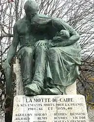 War memorial | |
 Coat of arms | |
Location of La Motte-du-Caire 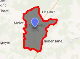
| |
 La Motte-du-Caire  La Motte-du-Caire | |
| Coordinates: 44°20′40″N 6°01′45″E | |
| Country | France |
| Region | Provence-Alpes-Côte d'Azur |
| Department | Alpes-de-Haute-Provence |
| Arrondissement | Forcalquier |
| Canton | Seyne |
| Government | |
| • Mayor (2014–2020) | Patrick Massot[1] |
| Area 1 | 27.27 km2 (10.53 sq mi) |
| Population (2017-01-01)[2] | 560 |
| • Density | 21/km2 (53/sq mi) |
| Time zone | UTC+01:00 (CET) |
| • Summer (DST) | UTC+02:00 (CEST) |
| INSEE/Postal code | 04134 /04250 |
| Elevation | 623–1,547 m (2,044–5,075 ft) (avg. 707 m or 2,320 ft) |
| 1 French Land Register data, which excludes lakes, ponds, glaciers > 1 km2 (0.386 sq mi or 247 acres) and river estuaries. | |
Population
| Year | Pop. | ±% |
|---|---|---|
| 1765 | 645 | — |
| 1793 | 550 | −14.7% |
| 1800 | 581 | +5.6% |
| 1806 | 611 | +5.2% |
| 1821 | 574 | −6.1% |
| 1831 | 692 | +20.6% |
| 1836 | 692 | +0.0% |
| 1841 | 719 | +3.9% |
| 1846 | 717 | −0.3% |
| 1851 | 720 | +0.4% |
| 1856 | 659 | −8.5% |
| 1861 | 680 | +3.2% |
| 1866 | 690 | +1.5% |
| 1872 | 646 | −6.4% |
| 1876 | 686 | +6.2% |
| 1881 | 715 | +4.2% |
| 1886 | 697 | −2.5% |
| 1891 | 678 | −2.7% |
| 1896 | 652 | −3.8% |
| 1901 | 626 | −4.0% |
| 1906 | 595 | −5.0% |
| 1911 | 559 | −6.1% |
| 1921 | 483 | −13.6% |
| 1926 | 458 | −5.2% |
| 1931 | 444 | −3.1% |
| 1936 | 477 | +7.4% |
| 1946 | 376 | −21.2% |
| 1954 | 341 | −9.3% |
| 1962 | 362 | +6.2% |
| 1968 | 347 | −4.1% |
| 1975 | 420 | +21.0% |
| 1982 | 403 | −4.0% |
| 1990 | 438 | +8.7% |
| 1999 | 484 | +10.5% |
| 2008 | 507 | +4.8% |
References
| Wikimedia Commons has media related to La Motte-du-Caire. |
| Authority control |
|
|---|
This article is issued from Wikipedia. The text is licensed under Creative Commons - Attribution - Sharealike. Additional terms may apply for the media files.