La Penne-sur-Huveaune
La Penne-sur-Huveaune (French pronunciation: [la pɛn syʁ‿yvon]; Provençal: La Pena d’Evèuna) is a commune east of Marseille and west of Aubagne along the A50 autoroute in the department of Bouches-du-Rhône in the Provence-Alpes-Côte d'Azur region in southern France.
La Penne-sur-Huveaune | |
|---|---|
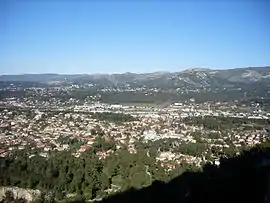 La Penne-sur-Huveaune viewed from the summit of a nearby hill | |
.svg.png.webp) Coat of arms | |
Location of La Penne-sur-Huveaune 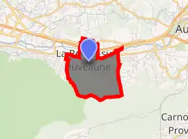
| |
 La Penne-sur-Huveaune  La Penne-sur-Huveaune | |
| Coordinates: 43°16′50″N 5°30′57″E | |
| Country | France |
| Region | Provence-Alpes-Côte d'Azur |
| Department | Bouches-du-Rhône |
| Arrondissement | Marseille |
| Canton | Aubagne |
| Intercommunality | Aix-Marseille-Provence |
| Government | |
| • Mayor (2020–2026) | Christine Capdeville |
| Area 1 | 3.56 km2 (1.37 sq mi) |
| Population (2017-01-01)[1] | 6,436 |
| • Density | 1,800/km2 (4,700/sq mi) |
| Time zone | UTC+01:00 (CET) |
| • Summer (DST) | UTC+02:00 (CEST) |
| INSEE/Postal code | 13070 /13821 |
| Dialling codes | 0491 |
| Elevation | 70–404 m (230–1,325 ft) (avg. 105 m or 344 ft) |
| 1 French Land Register data, which excludes lakes, ponds, glaciers > 1 km2 (0.386 sq mi or 247 acres) and river estuaries. | |
The river Huveaune flows through it, from which the commune derived its name.
Population
|
|
References
- "Populations légales 2017". INSEE. Retrieved 6 January 2020.
| Wikimedia Commons has media related to Penne-sur-Huveaune. |
| Authority control |
|---|
This article is issued from Wikipedia. The text is licensed under Creative Commons - Attribution - Sharealike. Additional terms may apply for the media files.