List of Baltimore neighborhoods
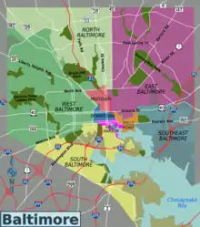
Neighborhoods in the City of Baltimore are officially divided into nine geographical regions: North, Northeast, East, Southeast, South, Southwest, West, Northwest, and Central, with each district patrolled by a respective Baltimore Police Department. Charles Street down to Hanover Street and Ritchie Highway serve as the east-west dividing line and Eastern Avenue to Route 40 as the north-south dividing line. However, Baltimore Street is north-south dividing line for the U.S. Postal Service.[1] It is not uncommon for locals to divide the city simply by East or West Baltimore, using Charles Street or I-83 as a dividing line.

The following is a list of major neighborhoods in the city of Baltimore, Maryland, organized by broad geographical location within the city. See below for a list of maps published by the City of Baltimore Department of Planning.
Baltimore City neighborhoods

Northwest
- Arlington
- Ashburton
- Burleigh-Leighton
- Callaway-Garrison
- Central Forest Park
- Central Park Heights
- Cheswolde
- Cross Country
- Dolfield
- Dorchester
- East Arlington
- Fallstaff
- Forest Park/Howard Area
- Gwynn Oak
- Glen
- Grove Park
- Hanlon Park – Longwood
- Howard Park
- Langston Hughes
- Liberty Square
- Lucille Park
- Northwest Community Action
- Park Circle
- Park Heights
- Pimlico
- Purnell
- Reisterstown Station
- Towanda-Grantley
- West Hill Square
- West Forest Park
- Windsor Hills
- Woodmoor
- Rosemont
North
- Abell
- Bellona-Gittings
- Better Waverly
- Barclay
- Cameron Village
- Cedarcroft
- Charles North
- Charles Village, (formerly Peabody Heights)
- Chinquapin Park-Belvedere
- Cold Spring
- Village of Cross Keys, (off Falls Road)
- Cylburn, (near Cylburn Arboreteum)
- Edgecomb
- Evergreen, (part of Roland Park – near "Evergreen House" [Garrett Mansion] on Charles Street)
- Govans (formerly Govanstown)
- Glen Oaks
- Greenspring
- Guilford
- Hampden
- Harwood
- Hoes Heights
- Homeland
- Kenilworth Park
- Kernewood
- Keswick
- Lake Evesham
- Lake Walker
- Levindale
- Loyola-Notre Dame (Loyola College – now Loyola University Maryland and College of Notre Dame of Maryland – now Notre Dame of Maryland University area, North Charles Street and East Cold Spring lane)
- Mid-Charles
- Mid-Govans
- Mount Washington
- Medfield
- New North Roland Park-Poplar Hill
- Oakenshawe
- Old Goucher
- The Orchards
- Pen Lucy
- Radnor-Winston
- Remington
- Richnor Springs
- Roland Park
- Rosebank (part of Govans)
- Sabina Mattefeldt
- Saint Paul
- Station North Arts and Entertainment District, (formerly Penn-North-Charles or Mid-Town)
- Tuscany-Canterbury
- Waverly
- Wilson Park
- Winston-Govans
- Woodberry
- Woodbourne Heights
- Woodbourne-McCabe
- Wyman Park
- Wyndhurst
Northeast
- Arcadia
- Armistead Gardens
- Belair-Edison
- Belair-Parkside
- Beverly Hills
- Cedmont
- Cedonia
- Christopher
- Coldstream-Homestead-Montebello
- Orchard Ridge
- Ednor Gardens-Lakeside
- Four by Four
- Frankford
- Gardenville
- Glenham-Belford
- Hamilton
- Harford-Echodale-Perring Parkway
- Hillen
- Hollander Ridge
- Idlewood
- Lauraville
- Loch Raven
- Mayfield
- Mayfield-Montebello
- Moravia-Walther
- Morgan Park
- North Harford Road
- Northwood, Baltimore
- Overlea
- Parkside
- Perring-Loch
- Ramblewood
- Rosemont Avenue
- Stonewood-Pentwood-Winston
- Taylor Heights
- Waltherson
- Westfield
- Wilson Heights
- Wilson Park
- Woodbourne Heights
- Woodring
West

- Allendale
- Bridgeview-Greenlawn
- Coppin Heights
- Easterwood
- Edmondson Village
- Evergreen Lawn
- Franklin Square
- Harlem Park
- Heritage Crossing
- Lexington
- Midtown-Edmondson
- Mondawmin
- Mosher
- Panway-Braddish
- Penn-North
- Poppleton
- Rosemont
- Sandtown-Winchester
- Union Square
- Upton
- Walbrook
Central
- Bolton Hill
- Charles Center
- Charles North, (formerly known as Charles-North, or Penn-North-Charles)
- Cathedral Hill [2]
- Bromo Arts District (formerly known as Westside)[3]
- Preston Gardens [4]
- Downtown
- Druid Heights
- Heritage Crossing
- Inner Harbor
- Lakeview Towers
- Lexington Terrace
- Madison Park
- Market Center[5][6]
- McCulloh Homes
- Midtown-Belvedere
- Mount Vernon
- Otterbein
- Reservoir Hill
- Ridgely's Delight
- Seton Hill
- Somerset Homes
- Station North
- Upton
East

- Armistead Gardens
- Barclay
- Berea
- Biddle Street
- Broadway East
- Darley Park
- Douglass Homes
- Dunbar-Broadway
- East Baltimore Midway
- Eager Park[7]
- Ellwood Park
- Gay Street
- Greenmount West
- Johnston Square
- Latrobe Homes
- Madison-Eastend
- McElderry Park
- Milton-Montford
- Old Town
- Oliver
- Orangeville
- Penn-Fallsway
- Pleasant View Gardens
- Somerset Holmes-Monument East
- South Clifton Park
Southwest
- Allendale
- Barre Circle
- Beechfield
- Bentalou-Smallwood
- Booth-Boyd
- Carrollton Ridge
- Carroll South
- Dickeyville
- Edmondson
- Fairmount
- Franklintown
- Gwynn's Falls
- Hillside Park
- Hilton
- Hollins Market
- Irvington
- Hillside Park
- Mill Hill
- Monastery Gardens
- Morrell Park
- Mount Holly
- Oaklee
- Pigtown, (aka: Washington Village)
- Pratt Monroe
- Primrose Place
- Ridgely's Delight
- Rognel Heights
- Rosemont
- Saint Agnes
- Saint Joseph's
- Shipley Hill
- Sowebo
- Ten Hills
- Tremont
- Uplands
- Violetville
- Wakefield
- Wallbrook
- Westgate
- West Hills
- West Mullberry
- Western
- West Pratt
- Winchester
- Windsor Hills
- Yale Heights
South

- Arundel Cove, (defunct – west of Hawkins Point, by United States Coast Guard Yard at Curtis Bay)
- Brooklyn
- Brooklyn Homes
- Cherry Hill
- Curtis Bay
- Fairfield, (mostly vacant, composed of old Fairfield and Fairfield Homes [razed])
- Federal Hill
- Harborview, (Harborview Tower – [apts.-condos], off Key Highway)
- Hawkins Point
- Lakeland
- Locust Point
- Masonville, (defunct – razed by construction of Baltimore Harbor Tunnel Thruway (1957)
- Mount Winans
- Otterbein
- Port Covington
- Riverside
- South Balto.Imp.Comm./West Federal Hill
- Sharp-Leadenhall
- Shoreline
- South Baltimore, (old South Baltimore, north of Hanover Street Bridge, [1917])
- Wagner's Point, (also known as East Brooklyn – razed 1990's)
- Westport
Southeast
- Baltimore Highlands
- Bayview or Hopkins Bayview
- Brewer's Hill
- Butchers Hill
- Canton
- Douglass Homes
- Dunbar
- Eastwood
- Ellwood Park
- Fells Point
- Fells Prospect
- Fifteenth Street
- Graceland Park
- Greektown
- Harbor East
- Harbor Point, (continuation of Harbor East development – site of old Allied-Signal chromium plant)
- Highlandtown
- Jonestown
- Joseph Lee
- Kresson
- Little Italy
- McElderry Park
- Medford-Broening Highway
- O'Donnell Heights
- Patterson Park
- Patterson Place
- Perkins Homes
- Pleasant View Gardens
- St Helena
- Upper Fells Point
- Washington Hill
Maps
See also
References
- Mary K. Tilghman (2008). Insiders' Guide to Baltimore. Morris Book Publishing LLC. p. 2. ISBN 978-0-7627-4553-1.
- "Cathedral Hill". Downtown Baltimore. Downtown Partnership of Baltimore. Retrieved April 30, 2018.
- "It's Happening In the Bromo". Bromo Arts District. Retrieved April 30, 2018.
- "Preston Garden". "Downtown Baltimore. Downtown Partnership of Baltimore. Retrieved April 30, 2018.
- "About Market Center". Market Center Baltimore. Market Center Baltimore. 2017. Retrieved June 6, 2019.
Market Center’s land use is governed both by the Zoning Code of Baltimore City and the Market Center Urban Renewal Plan (URP).
- "History - Chesapeake Commons". Chesapeake Commons. Chesapeake Commons. 2018. Retrieved June 6, 2019.
Chesapeake Commons is located in Market Center, a traditional retail district flanked on either side by two historic neighborhoods, Seton Hill and Mount Vernon.
- "EBDI's momentum". The Baltimore Sun. September 12, 2016.
External links
- Your District (list of neighborhoods by district)
- The Baltimore Neighborhood Indicators Alliance
- Patterson Park Neighborhood Association Website
- Live Baltimore Website

