List of state highways in South Dakota
South Dakota's state highways were assigned in a numbering pattern that followed that of the U.S. Highways followed upon their inception. East–west highways carried even numbers and increased from North to South – while north–south highways carried odd numbers and increased from east to west. This holds true only for two-digit highways. Three-digit highways follow the odd–even routing, but do not sequentially remain near a "parent" route as a spur or alternate route, instead being more independent of any parent two-digit route.[1]
  Standard South Dakota state highway shields | |
| System information | |
|---|---|
| Notes | South Dakota highways are generally state-maintained. |
| Highway names | |
| Interstates | Interstate X (I-X) |
| US Highways | U.S. Highway X (US X) |
| State | (State) Highway X (SD X) |
| System links | |
| |
The Bureau of Indian Affairs maintains a set of routes within the reservations of western South Dakota – using the standard BIA shield on green background.[1]
State highways
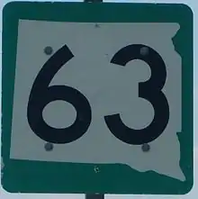
View of an actual South Dakota state highway sign. The signs enclose the route number within the state's shape on top of a green background.
| Number | Length (mi) | Length (km) | Southern or western terminus | Northern or eastern terminus | Formed | Removed | Notes |
|---|---|---|---|---|---|---|---|
| 180 | 290 | Montana state line | Mobridge | 1935 | c. 1968 | absorbed by SD 20 when extended west across the Missouri River | |
| — | — | — | — | 1926 | 1927 | became U.S. Highway 16 | |
| — | — | — | — | 1935 | 1950 | was a short state route in Marshall County | |
| 175.945 | 283.156 | SD 1804 in Pollock | MN 28 at the Minnesota state line southeast of Sisseton | 1927 | current | ||
| 77.724 | 125.085 | South Franklin Street / East Rose Street in Elk Point | MN 269 at the Minnesota state line near Sherman | 1926 | current | segment between SD 50 and SD 48 is currently not a portion of the highway | |
| 325 | 523 | Mound City | Minnesota state line southeast of Sisseton | 1926 | 1927 | redesignated as SD 10 | |
| 23.891 | 38.449 | SD 34 east of Egan | US 14 north of Elkton | 1926 | current | ||
| 67.562 | 108.730 | SD 28 west of Toronto | CR 17 / CR 34 north of Summit | 1926 | current | ||
| — | — | Milbank | Wilmot | c. 1950 | 1976 | originally part of the SD 15 mainline; redesignated as SD 123 | |
| 67.562 | 108.730 | US 12 in Big Stone City | SD 15 southwest of Shady Beach | c. 1960 | 1976 | redesignated as SD 109 | |
| — | — | White Butte | Big Stone City | 1926 | 1927 | designated as part of US 12 | |
| — | — | — | — | — | — | ||
| 2.000 | 3.219 | SD 44 south of Lennox | CR 122 north of Lennox | 1926 | current | ||
| 200 | 320 | Montana state line | Mobridge | 1926 | c. 1935 | redesignated as South Dakota Highway 8 | |
| 86.974 | 139.971 | N-15 at the Nebraska state line south of Vermillion | SD 34 southeast of Madison | 1926 | current | designated as part of US 12 | |
| 8.161 | 13.134 | SD 19/SD 46 south of Centerville | SD 19 west of Centerville | 1950 | current | originally part of SD 19 | |
| 385.079 | 619.725 | Montana state line near Camp Crook | MN 40 at the Minnesota state line near Revillo | c. 1930 | current | follows US 212, US 81 and I-29 between two segments of US 12 | |
| — | — | SD 20 in Akaska | SD 20 in Akaska | c. 1965 | 1976 | Redesignated as SD 144 | |
| 0.458 | 0.737 | SD 20 near Watertown | North Lake Drive near Watertown | — | — | ||
| 9.470 | 15.240 | SD 28 west of Lake Norden | US 81 east of Hayti | c. 1926 | current | ||
| 48.546 | 78.127 | CR 181 in Hazel | MN 68 at the Minnesota state line south of Gary | c. 1926 | current | ||
| — | — | — | — | c. 1968 | 1976 | redesignated as SD 101 | |
| — | — | — | — | — | — | ||
| 148 | 238 | Belle Fourche | Faith | c. 1926 | 1960 | eliminated by a westward extension of SD 34 | |
| 27 | 43 | Belle Fourche | Black Hills | c. 1940 | 1948 | ||
| 194.524 | 313.056 | SD 50 northwest of Tabor | ND 18 at the North Dakota state line north of Claire City | 1926 | current | gap in route designated as CR 9 | |
| 49.540 | 79.727 | SD 47 north of Highmore | US 281 south of Redfield | c. 1935 | current | ||
| — | — | — | Hutchinson | c. 1926 | 1935 | redesignated as part of SD 35 | |
| 42.639 | 68.621 | US 12 southeast of Andover | ND 32 at the North Dakota state line northeast of Kidder | 1976 | current | originally northern part of the path of SD 25 | |
| 105.937 | 170.489 | US 281 west of Hitchcock | MN 271 at the Minnesota state line near Astoria | c. 1934 | current | ||
| — | — | Wyoming border southwest of Lead | Minnesota border near Elkton | c. 1926 | 1927 | ||
| 17.1 | 27.5 | CR 6/CR 77 west of White | MN 19 at the Minnesota state line northeast of Bushnell | c. 1955 | current | ||
| 8.6 | 13.8 | I-29 (via Exit 114) | SD 13 in Flandreau | — | — | ||
| 419.0 | 674.3 | WYO 24 at the Wyoming state line | MN 30 at the Minnesota state line | — | — | ||
| 19 | 31 | Near Tabor | Near Emery | c. 1935 | 1976 | ||
| 9.1 | 14.6 | US 16A in Custer State Park | SD 79 near Hermosa | — | — | ||
| 242.0 | 389.5 | N-14 at the Nebraska state line | ND 1 at the North Dakota state line | — | — | ||
| 2.4 | 3.9 | SD 37 south of Tripp | US 18 north of Tripp | — | — | Business loop of highway 37 in Tripp | |
| 63.4 | 102.0 | I-90 Business in Mitchell | I-29 in Sioux Falls | — | — | ||
| — | — | — | — | — | — | ||
| 37.4 | 60.2 | US 16A in Keystone | BIA Highway 41 in Red Shirt | — | — | ||
| — | — | — | — | — | — | ||
| 197 | 317 | Ravinia | North Dakota | 1926 | c. 1952 | absorbed by US 281 | |
| 5.9 | 9.5 | US 281 | Aurora-Davison county line | — | — | ||
| 80.9 | 130.2 | SD 37 west of Ethan | IA 9 at the Iowa state line near Larchwood | — | — | ||
| 1.1 | 1.8 | N-11 at the Nebraska state line | US 18 in Fairfax | — | — | ||
| 379.0 | 609.9 | US 385 near Merritt | I-29 near Worthing | — | — | ||
| 198.0 | 318.7 | SD 44 / SD 50 in Platte | ND 3 at the North Dakota state line near Ashley | — | — | ||
| 105.5 | 169.8 | US 18 / US 281 in Pickstown | IA 10 at the Iowa state line near Hawarden | — | — | ||
| — | — | — | — | — | — | ||
| 240.9 | 387.7 | N-137 at the Nebraska state line | North Dakota state line | — | — | ||
| — | — | — | — | — | — | ||
| 12.5 | 20.1 | I-29 near Spink | Iowa state line near Akron | — | — | ||
| 35.1 | 56.5 | US 18 / US 183 in Colome | SD 47 | — | — | ||
| 212.4 | 341.8 | SD 34 near Fort Thompson | IA 3 at the Iowa state line near Richland | — | — | ||
| 28.6 | 46.0 | SD 37 near Springfield | US 81 / SD 50 in Yankton | — | — | ||
| 16.0 | 25.7 | 293rd Street/306th Avenue near Clearfield | US 18 near Jordan Junction | — | — | ||
| 33.1 | 53.3 | SD 44 near Wood | I-90 / US 83 in Vivian | — | — | ||
| 16 | 26 | Bonesteel | Nebraska | c. 1926 | c. 1960 | ||
| — | — | — | — | — | — | ||
| 51 | 82 | Nebraska | Murdo | 1927 | c. 1935 | replaced by US 183 | |
| — | — | — | — | — | — | ||
| 20.8 | 33.5 | US 18 near Parmelee | 246th avenue near Norris | — | — | ||
| 146.6 | 235.9 | SD 44 south of Corn Creek | ND 6 at the North Dakota state line near McLaughlin | — | — | ||
| 70.5 | 113.5 | US 212 near Dupree | ND 31 near McIntosh | — | — | ||
| 35.6 | 57.3 | N-2 / N-71 at the Nebraska state line near Ardmore | US 18 Bypass in Hot Springs | — | — | ||
| 255.3 | 410.9 | N-61 near Merriman | ND 49 at the North Dakota state line near Thunder Hawk | — | — | ||
| 29.4 | 47.3 | SD 20 near Bison | ND 8 at the North Dakota state line near Hettinger | — | — | ||
| — | — | — | — | — | — | ||
| — | — | — | — | — | — | ||
| — | — | — | — | — | — | ||
| — | — | — | — | — | — | ||
| — | — | — | — | — | — | ||
| — | — | — | — | — | — | ||
| — | — | — | — | — | — | ||
| — | — | — | — | — | — | ||
| — | — | — | — | — | — | ||
| — | — | — | — | — | — | ||
| — | — | — | — | — | — | ||
| — | — | — | — | — | — | ||
| — | — | — | — | — | — | ||
| — | — | — | — | — | — | ||
| — | — | — | — | — | — | ||
| — | — | — | — | — | — | ||
| — | — | — | — | — | — | ||
| — | — | — | — | — | — | ||
| — | — | — | — | — | — | ||
| — | — | — | — | — | — | ||
| — | — | — | — | — | — | ||
| — | — | — | — | — | — | ||
| — | — | — | — | — | — | ||
| — | — | — | — | — | — | ||
| — | — | — | — | — | — | ||
| — | — | — | — | — | — | ||
| — | — | — | — | — | — | ||
| — | — | — | — | — | — | ||
| — | — | — | — | — | — | ||
| — | — | — | — | — | — | ||
| — | — | — | — | — | — | ||
| — | — | — | — | — | — | ||
| — | — | — | — | — | — | ||
| — | — | — | — | — | — | ||
| — | — | — | — | — | — | ||
| — | — | — | — | — | — | ||
| — | — | — | — | — | — | ||
| — | — | — | — | — | — | ||
| — | — | — | — | — | — | ||
| — | — | — | — | — | — | ||
| — | — | — | — | — | — | ||
| — | — | — | — | — | — | ||
| — | — | — | — | — | — | ||
| — | — | — | — | — | — | ||
| — | — | — | — | — | — | ||
| — | — | — | — | — | — | ||
| — | — | — | — | — | — | ||
| — | — | — | — | — | — | ||
| — | — | — | — | — | — | ||
| — | — | — | — | — | — | ||
| — | — | — | — | — | — | ||
| — | — | — | — | — | — | ||
| — | — | Black Hills Ordnance Depot at Igloo | SD 471 northeast of Igloo | — | 1998 | ||
| — | — | — | — | — | — | ||
| — | — | — | — | — | — | ||
| — | — | — | — | — | — | ||
| — | — | — | — | — | — | ||
| — | — | — | — | — | — | ||
| — | — | — | — | — | — | ||
| — | — | — | — | — | — | ||
| — | — | — | — | — | — | ||
| — | — | — | — | — | — | ||
| — | — | — | — | — | — | ||
| — | — | — | — | — | — | ||
| — | — | — | — | — | — | ||
| — | — | — | — | — | — | ||
| — | — | — | — | — | — | ||
| — | — | — | — | — | — | ||
| 126.745 | 203.976 | Shore of the Missouri River south of Geddes | ND 1804 at the North Dakota state line northwest of Pollock | 1975 | current | consists of 4 segments | |
| — | — | — | — | — | — |
See also
 U.S. Roads portal
References
- Geelhart, Chris. "The Unofficial South Dakota Highways Page". Retrieved January 17, 2018.
External links
This article is issued from Wikipedia. The text is licensed under Creative Commons - Attribution - Sharealike. Additional terms may apply for the media files.