National Register of Historic Places listings in Bristol, Rhode Island
List of Registered Historic Places in Bristol, Rhode Island, which has been transferred from and is an integral part of National Register of Historic Places listings in Bristol County, Rhode Island
Bristol | Kent | Newport | Providence | Washington |
- This National Park Service list is complete through NPS recent listings posted February 5, 2021.[1]
| [2] | Name on the Register[3] | Image | Date listed[4] | Location | City or town | Description |
|---|---|---|---|---|---|---|
| 1 | Blithewold |  Blithewold |
June 27, 1980 (#80000074) |
Ferry Rd. 41°39′14″N 71°16′07″W |
Bristol | 1890s summer retreat established by Augustus Van Wickle, Pennsylvania coal magnate |
| 2 | Bristol County Courthouse | 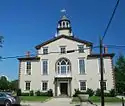 Bristol County Courthouse |
April 28, 1970 (#70000011) |
High St. 41°39′48″N 71°16′17″W |
Bristol | |
| 3 | Bristol County Jail | 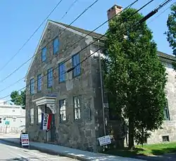 Bristol County Jail |
April 24, 1973 (#73000048) |
48 Court St. 41°40′10″N 71°16′32″W |
Bristol | |
| 4 | Bristol Customshouse and Post Office | 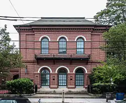 Bristol Customshouse and Post Office |
May 31, 1972 (#72000015) |
420-448 Hope St. 41°39′58″N 71°16′31″W |
Bristol | |
| 5 | Bristol Ferry Lighthouse | 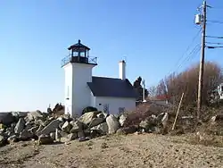 Bristol Ferry Lighthouse |
February 25, 1988 (#87001696) |
Ferry Rd. 41°38′35″N 71°15′37″W |
Bristol | |
| 6 | Bristol Waterfront Historic District | 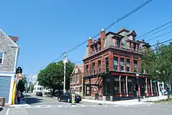 Bristol Waterfront Historic District |
March 18, 1975 (#75000053) |
Bristol Harbor to E side of Wood St. as far N as Washington St. and S to Walker Cove 41°40′10″N 71°16′31″W |
Bristol | |
| 7 | Benjamin Church House | 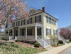 Benjamin Church House |
September 22, 1971 (#71000011) |
1014 Hope St. 41°41′09″N 71°16′43″W |
Bristol | |
| 8 | Juniper Hill Cemetery |  Juniper Hill Cemetery |
June 3, 1998 (#98000632) |
24 Sherry Ave. 41°40′53″N 71°16′06″W |
Bristol | |
| 9 | Longfield |  Longfield |
July 17, 1972 (#72000016) |
1200 Hope St. 41°41′49″N 71°16′47″W |
Bristol | |
| 10 | Mount Hope Bridge |  Mount Hope Bridge |
January 31, 1976 (#76000038) |
RI 114 over Narragansett Bay 41°38′25″N 71°15′32″W |
Bristol | |
| 11 | Mount Hope Farm | 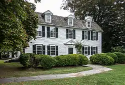 Mount Hope Farm |
May 2, 1977 (#77000023) |
Metacom Ave. 41°40′09″N 71°14′50″W |
Bristol | |
| 12 | Poppasquash Farms Historic District |  Poppasquash Farms Historic District |
June 27, 1980 (#80000075) |
Off RI 114 41°40′45″N 71°17′44″W |
Bristol | Includes Colt State Park and adjacent properties. |
| 13 | Joseph Reynolds House |  Joseph Reynolds House |
May 31, 1972 (#72000017) |
956 Hope St. 41°41′01″N 71°16′46″W |
Bristol | Oldest three-story frame house in New England, dating to 1700. Used as headquarters by Lafayette during 1778 Rhode Island campaign. |
See also
References
- "National Register of Historic Places: Weekly List Actions". National Park Service, United States Department of the Interior. Retrieved on February 5, 2021.
- Numbers represent an alphabetical ordering by significant words. Various colorings, defined here, differentiate National Historic Landmarks and historic districts from other NRHP buildings, structures, sites or objects.
- "National Register Information System". National Register of Historic Places. National Park Service. March 13, 2009.
- The eight-digit number below each date is the number assigned to each location in the National Register Information System database, which can be viewed by clicking the number.
| Topics | _(extra_close)_(US48).svg.png.webp) | ||||||||||
|---|---|---|---|---|---|---|---|---|---|---|---|
| Lists by county | |||||||||||
| Lists by city |
| ||||||||||
| |||||||||||
This article is issued from Wikipedia. The text is licensed under Creative Commons - Attribution - Sharealike. Additional terms may apply for the media files.