Newnan, Georgia
Newnan is a city in Metro Atlanta and the county seat of Coweta County, Georgia, approximately 40 miles (64 km) southwest of Atlanta. The population was 33,039 at the 2010 census,[5] up from 16,242 in 2000, for a growth rate of 103.4% over that decade.
Newnan, Georgia | |
|---|---|
| City of Newnan | |
 Seal | |
| Motto(s): City of Homes | |
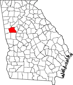
 Location in Coweta County and the state of Georgia | |
 Newnan Location of Newnan in Metro Atlanta | |
| Coordinates: 33°22′35″N 84°47′19″W | |
| Country | United States |
| State | Georgia |
| County | Coweta |
| Incorporated (city) | December 20, 1828 |
| Area | |
| • Total | 19.66 sq mi (50.92 km2) |
| • Land | 19.32 sq mi (50.03 km2) |
| • Water | 0.34 sq mi (0.89 km2) |
| Elevation | 971 ft (296 m) |
| Population (2010) | |
| • Total | 33,039 |
| • Estimate (2019)[2] | 41,581 |
| • Density | 2,152.56/sq mi (831.10/km2) |
| Time zone | UTC-5 (Eastern (EST)) |
| • Summer (DST) | UTC-4 (EDT) |
| ZIP Code | 30263-30265, 30271 |
| Area code(s) | 770, 678 |
| FIPS code | 13-55020[3] |
| GNIS feature ID | 0332499[4] |
| Website | ci |
History
.jpg.webp)
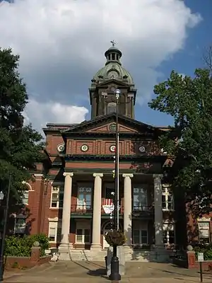
Newnan was established as county seat of Coweta County (replacing the defunct town of Bullsboro) in 1828 and was named for North Carolinian General Daniel Newnan. It quickly became a prosperous magnet for lawyers, doctors, other professionals, and merchants. Much of Newnan's prosperity was due to its thriving cotton industry, which relied on slavery.
Newnan was largely untouched by the Civil War due to its status as a hospital city (for both Union and Confederate troops), and as a result still features much antebellum architecture.[6] Celebrated architect Kennon Perry designed many of the town's 20th century homes. During the Atlanta Campaign, Confederate cavalry defeated Union forces at the nearby Battle of Brown's Mill.
On April 23, 1899, a notorious lynching occurred after an African-American man by the name of Sam Hose (born Tom Wilkes) was accused of killing his boss, Alfred Cranford. Hose was abducted from police custody, paraded through Newnan, tortured, and burned alive just north of town by a lynch mob of approximately 2,000 citizens of Coweta County.
Newnan was also host to the trial in 1948 of wealthy landowner John Wallace, the first white man in the South to be condemned to death by the testimony of African Americans, two field hands who were made to help with burning the body of murdered white sharecropper Wilson Turner. These events were portrayed in the novel Murder in Coweta County. The film version starred Johnny Cash, Andy Griffith, and June Carter.
In 1968 Kmart opened a warehouse in Newnan which slowly established Newnan as a major hub for distribution in the area.[7] Around this time, the International Brotherhood of Teamsters attempted to unionize the warehouse, but the attempt was defeated when the employees voted 329 to 201 in favor of remaining union-free.[8] In 2015 the distribution center closed with a loss of 164 jobs.[9]
Arts and culture
The city is home to one of the few Georgia counties with a museum that focuses mainly on African American history. The Coweta County African American Heritage Museum and Research Center, or Caswell House, was opened in July 2003 in a donated mill village house once owned by Ruby Caswell. The museum sits on Farmer Street on an old, unmarked slave cemetery. It has collected hundreds of family genealogical records by interviewing residents and going through the census records.[10] The museum also houses the Coweta Census Indexes from 1870 to 1920.[11]
The first black library in the county was the Sara Fisher Brown Library. Built in the 1950s, the library has since been converted into the Community Action For Improvement Center.[12]
The Farmer Street Cemetery is the largest slave cemetery in the South, and may be the largest undisturbed one in the nation. It is within the city limits of Newnan.
Geography
Newnan is located in the center of Coweta County at 33°22′35″N 84°47′19″W (33.376411, -84.788648).[13] U.S. Route 29 passes through the center of the city, leading northeast 13 miles (21 km) to Palmetto and south 7 miles (11 km) to Moreland. Interstate 85 passes through the eastern side of the city, with access from exits 41, 44, and 47. I-85 leads northeast 40 miles (64 km) to downtown Atlanta and southwest 125 miles (201 km) to Montgomery, Alabama. U.S. Route 27A leads northwest from the center of Newnan 22 miles (35 km) to Carrollton.
According to the United States Census Bureau, Newnan has a total area of 18.6 square miles (48.3 km2), of which 18.3 square miles (47.4 km2) is land and 0.35 square miles (0.9 km2), or 1.88%, is water.[5]
Climate
The climate is moderate with an average temperature of 64.3 degrees Fahrenheit (45.8 degrees in the winter and 79.1 degrees in the summer). The annual rainfall is 51.84 inches.
| Climate data for Newnan, Georgia | |||||||||||||
|---|---|---|---|---|---|---|---|---|---|---|---|---|---|
| Month | Jan | Feb | Mar | Apr | May | Jun | Jul | Aug | Sep | Oct | Nov | Dec | Year |
| Average high °F (°C) | 52 (11) |
58 (14) |
65 (18) |
73 (23) |
80 (27) |
86 (30) |
89 (32) |
88 (31) |
83 (28) |
73 (23) |
64 (18) |
55 (13) |
72 (22) |
| Average low °F (°C) | 31 (−1) |
33 (1) |
40 (4) |
47 (8) |
56 (13) |
64 (18) |
68 (20) |
67 (19) |
62 (17) |
49 (9) |
41 (5) |
33 (1) |
49 (10) |
| Average precipitation inches (mm) | 5.49 (139) |
5.14 (131) |
5.95 (151) |
4.17 (106) |
4.37 (111) |
3.99 (101) |
4.66 (118) |
4.00 (102) |
3.24 (82) |
2.86 (73) |
4.18 (106) |
4.27 (108) |
52.32 (1,329) |
| Average snowfall inches (cm) | 0.8 (2.0) |
0.5 (1.3) |
0.4 (1.0) |
0.1 (0.25) |
0 (0) |
0 (0) |
0 (0) |
0 (0) |
0 (0) |
0 (0) |
0 (0) |
0.2 (0.51) |
2 (5.06) |
| Source: The Weather Channel[14] | |||||||||||||
Transportation
Major roads
- Interstate 85
- Outer Perimeter
- State Route 34
- State Route 34 Bypass
- State Route 16
- State Route 70
- Lower Fayetteville Road
- Newnan Crossing Boulevard East
- Newnan Crossing Bypass
- U.S. Route 29
- U.S. Route 27A
Pedestrians and cycling
- LINC[15]
Airports
- Newnan–Coweta County Airport provides chartered air service and flight training.
Demographics
| Historical population | |||
|---|---|---|---|
| Census | Pop. | %± | |
| 1860 | 2,546 | — | |
| 1870 | 1,917 | −24.7% | |
| 1880 | 2,006 | 4.6% | |
| 1890 | 2,859 | 42.5% | |
| 1900 | 3,654 | 27.8% | |
| 1910 | 5,548 | 51.8% | |
| 1920 | 7,037 | 26.8% | |
| 1930 | 6,386 | −9.3% | |
| 1940 | 7,182 | 12.5% | |
| 1950 | 8,218 | 14.4% | |
| 1960 | 12,169 | 48.1% | |
| 1970 | 11,205 | −7.9% | |
| 1980 | 11,449 | 2.2% | |
| 1990 | 12,497 | 9.2% | |
| 2000 | 16,242 | 30.0% | |
| 2010 | 33,039 | 103.4% | |
| U.S. Decennial Census[16] | |||
Newnan's population is approximately 33,039 and Coweta County's population is approximately 127,400. From 2000 to 2010, the population of Coweta County grew by 42.7% as compared to from 1990 to 2000, when the county's population grew by 65.7%. Newnan's population grew by 30% from 1990 to 2000 and by 103.4% from 2000 to 2010.
The ethnic makeup of the city was 50.8% white alone, 37.6% African American alone, 0.3% Native American alone, 2.8% Asian alone, 0.1% Pacific Islander alone, 5.6% from "some other race" alone, and 2.8% from "two or more races". Hispanic or Latino of any race were 11.4% of the population.
There were 13,783 households, out of which 34.4% had children under the age of 18 living with them, 42.5% were married couples living together, 17.7% had a female householder with no husband present, and 33.4% were non-families. 28.6% of all households were made up of individuals, and 7.3% had someone living alone who was 65 years of age or older. The average household size was 2.61 and the average family size was 3.17. In the city, the population was spread out, with 30.8% under the age of 19, 7.8% from 20 to 24, 29.8% from 25 to 44, 21.9% from 45 to 64, and 9.8% who were 65 years of age or older. The median age was 33.3 years.
The median income for a household in the city was $50,175 and the median income for a family was $64,615. Males had a median income of $50,753 versus $39,691 for females. The per capita income for the city was $19,081. About 17.3% of families and 22.0% of the population were below the poverty line, including 32.0% of those under age 18 and 5.7% of those age 65 or over.[17]
Education
Coweta County School District
The Coweta County School District holds pre-school to grade twelve, and consists of nineteen elementary schools, six middle schools, and three high schools.[18] The district has 1,164 full-time teachers and over 18,389 students.[19]
Elementary Schools
- Arbor Springs Elementary
- Arnco-Sargent Elementary
- Atkinson Elementary
- Brooks Elementary
- Canongate Elementary
- Eastside Elementary
- Elm Street Elementary
- Grantville Elementary
- Jefferson Parkway Elementary
- Moreland Elementary
- Newnan Crossing Elementary
- Northside Elementary
- Poplar Road Elementary
- Ruth Hill Elementary
- Thomas Crossroads Elementary
- Western Elementary
- Welch Elementary
- White Oak Elementary
- Willis Road Elementary
Middle schools
- Arnall Middle School
- East Coweta Middle School
- Evans Middle School
- Lee Middle School
- Madras Middle School
- Smokey Road Middle School
- The Heritage School (private)
- Trinity Christian School, Newnan (private)
- Odyssey Charter School
High schools
- Newnan High School
- East Coweta High School
- Northgate High School
- Central Educational Center (Chartered Coweta County School System School)
- The Pentecostal Church of God Christian Academy (private)
- The Heritage School (private)
- Trinity Christian School, Newnan (private)
Higher education
Mercer University has a Regional Academic Center in Newnan. The center opened in 2010 and offers programs through the university's College of Continuing and Professional Studies.
The University of West Georgia has a campus located in Newnan, near downtown. This campus currently has two undergraduate programs: Bachelor of Science in Nursing and Early Childhood Education.[20]
Newnan is also home to a campus of West Georgia Technical College.[21]
Notable people
- Ellis Arnall, Governor of Georgia (1943–1947)
- Monica (singer), Grammy Award Winner singer, songwriter, actress, and entrepreneur
- Karsten Bailey, former National Football League (NFL) wide receiver with Seattle Seahawks and Green Bay Packers, Canadian Football League (CFL) Saskatchewan Roughriders
- Cam Bedrosian, Major League Baseball (MLB) pitcher for the Los Angeles Angels
- Steve Bedrosian, former MLB pitcher, winner of 1987 Cy Young Award
- Hamilton Bohannon, musician and record producer
- Keith Brooking, former linebacker with Georgia Tech and NFL's Atlanta Falcons, and Dallas Cowboys
- Erskine Caldwell, novelist and short fiction writer (1903-1987)
- Jack Tarpley Camp Jr., jurist
- Lewis Grizzard, author and newspaper columnist
- Drew Hill, former NFL wide receiver with Houston Oilers, Los Angeles Rams, and Atlanta Falcons
- Alan Jackson, Country Music Hall of Fame member
- Joe M. Jackson, United States Air Force colonel, Medal of Honor recipient
- Calvin Johnson, former All-Pro NFL wide receiver with Detroit Lions, second selection of 2007 NFL Draft
- John Keith, former NFL player
- Wil Lutz, NFL kicker with New Orleans Saints
- Mary Lyndon, first woman to receive degree from University of Georgia
- Warren Newson, MLB player with Chicago White Sox, Texas Rangers
- Alec Ogletree, NFL linebacker with Los Angeles Rams
- Stephen W. Pless, Marine Corps major, Medal of Honor recipient
- Rocky Roquemore, international golf course designer
- Jefferson Randolph "Soapy" Smith II, (1860–1898), infamous 19th Century gambler, confidence man and crime boss
- Will Smith, MLB pitcher for San Francisco Giants
- Doug Stone, country music singer-songwriter
- Jerome Walton, MLB player, 1989 Rookie of the Year
- Marie Robinson Wright (1853–1914), American journalist, traveler, historian, author
- William C. Wright, congressman (1918–1933)
- Steve Young, pioneer country rock musician
Television and movies
- The ABC television series October Road was filmed in Newnan,[22] which is set in the fictional town of Knights Ridge, Massachusetts.
- The TV movie Murder in Coweta County (1983), based on the book[23] by Margaret Anne Barnes, chronicles actual events that occurred around 1948.[24]
- The NBC series I'll Fly Away was filmed in Newnan from 1991–1993.[22]
- The 1995 movie Fluke was filmed in Newnan.[22]
- Pet Sematary Two (1992).[25]
- The 1979 movie The Sheriff and the Satellite Kid (Uno sceriffo extraterrestre... poco extra e molto terrestre) with Bud Spencer takes place and was filmed in Newnan.
- The Walking Dead TV series has several scenes filmed in Newnan, including Newnan High School and Sonrise Baptist Church.[26]
- The Netflix TV series Insatiable was filmed in Newnan.[27]
- Zombieland (2009)
- The Hunger Games: Mockingjay – Part 1 (2014)
- The Founder (2016)
- The House with a Clock in Its Walls (2018)
- Lovecraft Country (TV series) (2019)
- Many More, Complete List
References
- "2019 U.S. Gazetteer Files". United States Census Bureau. Retrieved July 9, 2020.
- "U.S. Census website". United States Census Bureau. Retrieved 2008-01-31.
- "US Board on Geographic Names". United States Geological Survey. 2007-10-25. Retrieved 2008-01-31.
- "Geographic Identifiers: 2010 Demographic Profile Data (G001): Newnan city, Georgia". U.S. Census Bureau, American Factfinder. Archived from the original on February 12, 2020. Retrieved July 30, 2014.
- "History". www.ci.newnan.ga.us. City of Newnan. Retrieved April 12, 2019.
- Mike Clary (March 31, 1992). "Workers Say Kmart Short-Changed Them". Los Angeles Times. Retrieved February 23, 2020.
- Kmart Corp, 316 N.L.R.B. 1175 (N.L.R.B. 1995)
- Aaron Hutchins (February 25, 2015). "Sears & Kmart closing update, 25 February 2015". blindbatnews.com. Retrieved February 23, 2020.
- Schindler, Madeline (July 24, 2017). "African American Museum remains open". The Newnan Times-Herald. Retrieved April 12, 2019.
- Dianne (March 30, 2008). "The Coweta County Museum, Newnan Georgia: Black Firsts in Coweta County". thecowetacountymuseum.blogspot.com. Retrieved April 5, 2018.
- "The Coweta County Museum, Newnan Georgia". thecowetacountymuseum.blogspot.com. Retrieved April 5, 2018.
- "US Gazetteer files: 2010, 2000, and 1990". United States Census Bureau. 2011-02-12. Retrieved 2011-04-23.
- "Monthly Averages for Newnan, GA". Weather.com. 2010. Retrieved 2010-03-15.
- "LINC construction set to begin".
- "Census of Population and Housing". Census.gov. Retrieved June 4, 2015.
- American Factfinder, ESRI
- Georgia Board of Education, Retrieved June 5, 2010.
- School Stats, Retrieved June 5, 2010.
- "University of West Georgia- Newnan." University of West Georgia. N.p., 2011. Web. 24 Aug 2011. <http://www.westga.edu/newnan/>.
- "Coweta Campus Central Educational Center." West Georgia Technical College. N.p., n.d. Web. 24 Aug 2011. <http://www.westgatech.edu/locations/coweta.htm Archived 2011-08-17 at the Wayback Machine>.
- "Filming in Coweta". Coweta County. Coweta County. Archived from the original on 2017-05-10. Retrieved 4 November 2016.
- "Good Reads Page for Murder in Coweta County book".
- "Murder in Coweta County IMDB".
- "Movies". New York Times.
- "Newnan Archives – The Walking Dead Locations". The Walking Dead Locations. Retrieved 5 April 2018.
- Campbell, Sarah Fay (March 24, 2017). "Two productions filming in downtown Newnan Wednesday". Newnan Times-Herald. Retrieved August 10, 2018.


