North Reading, Massachusetts
North Reading (pronounced, as is with Reading as North REDD-ing) is a town in Middlesex County, Massachusetts, United States. The population was 14,892 at the 2010 census.[1]
North Reading, Massachusetts | |
|---|---|
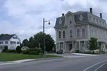
 North Reading Common | |
 Seal | |
 Location in Middlesex County in Massachusetts | |
| Coordinates: 42°34′30″N 71°04′45″W | |
| Country | United States |
| State | Massachusetts |
| County | Middlesex |
| Settled | 1651 |
| Incorporated | 1853 |
| Government | |
| • Type | Open town meeting |
| Area | |
| • Total | 13.5 sq mi (35.0 km2) |
| • Land | 13.3 sq mi (34.3 km2) |
| • Water | 0.3 sq mi (0.6 km2) |
| Elevation | 100 ft (30 m) |
| Population (2010) | |
| • Total | 14,892 |
| • Density | 1,100/sq mi (430/km2) |
| Time zone | UTC-5 (Eastern) |
| • Summer (DST) | UTC-4 (Eastern) |
| ZIP code | 01864 |
| Area code(s) | 351 / 978 |
| FIPS code | 25-48955 |
| GNIS feature ID | 0618230 |
| Website | http://www.northreadingma.gov |
History
The area was first settled in 1651 when the town of Reading received a special land grant north of the Ipswich River. It was officially incorporated as the separate town of North Reading in 1853. North Reading borders Andover, North Andover, Middleton, Lynnfield, Reading, and Wilmington.
A historical source wrote:
Original grants of large farmsteads along the river during the mid-17th century brought six families to the settlement before 1680. The economy of the town in the 17th and 18th century was based on subsistence farming with limited hop production. There was a sawmill on Lob's Pond by 1694 and grist and saw mills at the village center by 1794. Some small scale boot and shoe making was underway by 1820, and by 1850 small sheds or shops to make shoes were attached to almost every house in town. These shops produced cheap footwear that was sold south to clothe slaves, and the Civil War destroyed the town's industry. The principal products of the town in the early 20th century were milk, apples and fruits.[2]
Geography
According to the United States Census Bureau, the town has a total area of 13.5 square miles (35.0 km2), of which 13.2 square miles (34.3 km2) is land and 0.2 square miles (0.6 km2), or 1.85%, is water.
Demographics
| Year | Pop. | ±% |
|---|---|---|
| 1860 | 1,203 | — |
| 1870 | 942 | −21.7% |
| 1880 | 900 | −4.5% |
| 1890 | 874 | −2.9% |
| 1900 | 1,035 | +18.4% |
| 1910 | 1,059 | +2.3% |
| 1920 | 1,286 | +21.4% |
| 1930 | 1,945 | +51.2% |
| 1940 | 2,886 | +48.4% |
| 1950 | 4,402 | +52.5% |
| 1960 | 8,331 | +89.3% |
| 1970 | 11,264 | +35.2% |
| 1980 | 11,455 | +1.7% |
| 1990 | 12,002 | +4.8% |
| 2000 | 13,837 | +15.3% |
| 2010 | 14,892 | +7.6% |
| * = population estimate. Source: United States Census records and Population Estimates Program data.[3][4][5][6][7][8][9][10][11] | ||
As of the census[12] of 2000, there were 13,837 people, 4,795 households, and 3,754 families residing in the town. The population density was 1,044.0 people per square mile (403.2/km2). There were 4,870 housing units at an average density of 367.4 per square mile (141.9/km2). The racial makeup of the town was 97.53% White, 0.40% African American, 0.04% Native American, 1.30% Asian, 0.01% Pacific Islander, 0.24% from other races, and 0.48% from two or more backgrounds. Hispanic or Latino of any race were 0.74% of the population.
There were 4,795 households, out of which 40.0% had children under the age of 18 living with them, 68.9% were married couples living together, 7.0% had a female householder with no husband present, and 21.7% were non-families. 17.9% of all households were made up of individuals, and 6.1% had someone living alone who was 65 years of age or older. The average household size was 2.86 and the average family size was 3.28.
In the town, the population was spread out, with 27.5% under the age of 18, 5.5% from 18 to 24, 31.4% from 25 to 44, 25.2% from 45 to 64, and 10.4% who were 65 years of age or older. The median age was 38 years. For every 100 females, there were 97.1 males. For every 100 females age 18 and over, there were 94.5 males.
The median income for a household in the town was $76,962, and the median income for a family was $86,341. Males had a median income of $52,446 versus $39,458 for females. The per capita income for the town was $30,902. About 0.7% of families and 1.5% of the population were below the poverty line, including 0.4% of those under age 18 and 2.8% of those age 65 or over.
Government

The North Reading Board of Selectmen has five members who are elected to serve three-year overlapping terms. As specified in the Town Charter and the Massachusetts General Laws, they are the chief elected officers of the town. The board may enact rules and regulations in a variety of areas, as well as establish town policies and procedures on many issues, unless such issues are delegated by law or vote of the town meeting to another officer or board. The board appoints a Town Administrator who supervises and is responsible for the day-to-day operation of town government departments.
Education

- North Reading High School
- North Reading Middle School
- E. Ethel Little School
- Turner Hood School
- L. D. Batchelder School
Infrastructure
Emergency services
North Reading is protected by the North Reading Fire Department and North Reading Police Department. The fire department is staffed by full-time members, and is supplemented by a smaller call member roster.
Notable people
- William Taylor Adams, (1822–1897), author under the name "Oliver Optic"[13]
- George Frederick Root (1820–1895), an American songwriter who found fame during the American Civil War.
- Art Kenney (1916–2014), Major League baseball player and principal of North Reading High School.
- Edward J. Collins, Jr. (1943–2007), government official
- Tom Fitzgerald (b. 1968), general manager of the New Jersey Devils[14][15]
- Jonathan Bird (b.1969), Emmy-winning television producer[16]
- Jon Favreau (b.1981), director of speechwriting for Barack Obama, co-founder of Crooked Media, and co-host of the popular political podcast Pod Save America.
- Jimmy Vesey (b. 1993), ice hockey player with the Buffalo Sabres. Vesey attended and played for North Reading High School, Belmont Hill School, and Harvard University prior to signing with the New York Rangers in 2016.
- Ryan Fitzgerald (b. 1994), ice hockey player with the Providence Bruins. Fitzgerald played with the Boston College Eagles and was picked in the 4th round of the 2013 NHL Entry Draft by the Boston Bruins.
- Alexandra Carpenter (b. 1994), ice hockey player with the KRS Vanke Rays. Carpenter played with the Boston College Eagles, the Boston Pride, and was a member of Team USA at the 2014 Winter Olympics.
References
- "Profile of General Population and Housing Characteristics: 2010 Demographic Profile Data (DP-1): North Reading town, Middlesex County, Massachusetts". United States Census Bureau. Retrieved April 6, 2012.
- "A History of North Reading". Town of North Reading. Retrieved 17 November 2012.
- "TOTAL POPULATION (P1), 2010 Census Summary File 1, All County Subdivisions within Massachusetts". United States Census Bureau. Archived from the original on February 12, 2020. Retrieved September 13, 2011.
- "Massachusetts by Place and County Subdivision - GCT-T1. Population Estimates". United States Census Bureau. Archived from the original on February 12, 2020. Retrieved July 12, 2011.
- "1990 Census of Population, General Population Characteristics: Massachusetts" (PDF). US Census Bureau. December 1990. Table 76: General Characteristics of Persons, Households, and Families: 1990. 1990 CP-1-23. Archived from the original (PDF) on December 7, 2013. Retrieved July 12, 2011.
- "1980 Census of the Population, Number of Inhabitants: Massachusetts" (PDF). US Census Bureau. December 1981. Table 4. Populations of County Subdivisions: 1960 to 1980. PC80-1-A23. Retrieved July 12, 2011.
- "1950 Census of Population" (PDF). 1: Number of Inhabitants. Bureau of the Census. 1952. Section 6, Pages 21-10 and 21-11, Massachusetts Table 6. Population of Counties by Minor Civil Divisions: 1930 to 1950. Retrieved July 12, 2011. Cite journal requires
|journal=(help) - "1920 Census of Population" (PDF). Bureau of the Census. Number of Inhabitants, by Counties and Minor Civil Divisions. Pages 21-5 through 21-7. Massachusetts Table 2. Population of Counties by Minor Civil Divisions: 1900, 1910, and 1920. Retrieved July 12, 2011.
- "1890 Census of the Population" (PDF). Department of the Interior, Census Office. Pages 179 through 182. Massachusetts Table 5. Population of States and Territories by Minor Civil Divisions: 1880 and 1890. Retrieved July 12, 2011.
- "1870 Census of the Population" (PDF). Department of the Interior, Census Office. 1872. Pages 217 through 220. Table IX. Population of Minor Civil Divisions, &c. Massachusetts. Retrieved July 12, 2011.
- "1860 Census" (PDF). Department of the Interior, Census Office. 1864. Pages 220 through 226. State of Massachusetts Table No. 3. Populations of Cities, Towns, &c. Retrieved July 12, 2011.
- "U.S. Census website". United States Census Bureau. Retrieved 2008-01-31.
- Who Was Who in America, Historical Volume, 1607-1896. Chicago: Marquis Who's Who. 1963.
- "Former Billerica resident brings Stanley Cup to Ipswich River Park in North Reading". Wicked Local Billerica. Perinton, New York: GateHouse Media.
- http://www.nhl.com/ice/news.htm?id=433431
- "North Reading Resident, Jonathan Bird, Wins Emmy". North Reading Patch. AOL Inc.
External links
| Wikimedia Commons has media related to North Reading, Massachusetts. |
 North Reading travel guide from Wikivoyage
- Town of North Reading official website
