National Register of Historic Places listings in Belmont County, Ohio
This is a list of the National Register of Historic Places listings in Belmont County, Ohio.
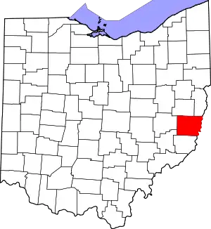
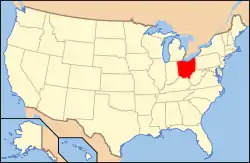
Location of Belmont County in Ohio
This is intended to be a complete list of the properties and districts on the National Register of Historic Places in Belmont County, Ohio, United States. The locations of National Register properties and districts for which the latitude and longitude coordinates are included below, may be seen in an online map.[1]
There are 27 properties and districts listed on the National Register in the county, including 1 National Historic Landmark. Another property was once listed but has been removed.
- This National Park Service list is complete through NPS recent listings posted January 29, 2021.[2]
Current listings
| [3] | Name on the Register[4] | Image | Date listed[5] | Location | City or town | Description |
|---|---|---|---|---|---|---|
| 1 | B & O Railroad Viaduct |  B & O Railroad Viaduct |
June 22, 1976 (#76001370) |
31st St. 40°00′47″N 80°44′40″W |
Bellaire | Extends into Benwood in Marshall County, West Virginia |
| 2 | Barnesville Baltimore and Ohio Railroad Depot |  Barnesville Baltimore and Ohio Railroad Depot |
August 8, 1985 (#85001694) |
300 E. Church St. 39°59′19″N 81°10′24″W |
Barnesville | |
| 3 | Barnesville Historic District |  Barnesville Historic District |
July 19, 1984 (#84002899) |
Roughly bounded by Arch, Main, Gardner, Chestnut, Bond, and Cherry Sts. 39°59′16″N 81°10′38″W |
Barnesville | |
| 4 | Barnesville Petroglyph |  Barnesville Petroglyph |
July 15, 1974 (#74001400) |
Off Track Rocks Road, southwest of Barnesville[6] 39°58′45″N 81°13′54″W |
Warren Township | |
| 5 | Belleview Heights | 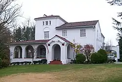 Belleview Heights |
April 8, 1994 (#94000259) |
65100 Candlewick Ln. 40°01′41″N 80°44′37″W |
Bellaire | |
| 6 | Belmont Historic District |  Belmont Historic District |
March 13, 1987 (#87000422) |
Roughly bounded by Barrister, John, Jefferson, Sycamore, and Bridge Sts. 40°01′46″N 81°02′25″W |
Belmont | |
| 7 | Blaine Hill "S" Bridge | 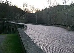 Blaine Hill "S" Bridge |
March 17, 2010 (#10000082) |
Township Road 649 at Blaine 40°04′01″N 80°49′15″W |
Pease Township | 385-foot-long (117 m) bridge with three stone arches; built in 1828; oldest standing bridge in Ohio[7] |
| 8 | Brick Tavern House | 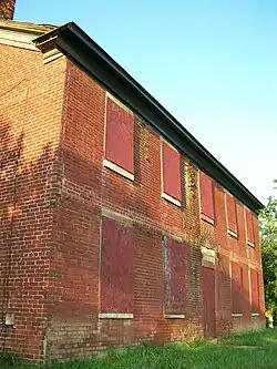 Brick Tavern House |
November 22, 1995 (#95001330) |
U.S. Route 40 west of St. Clairsville 40°04′25″N 80°58′58″W |
Richland Township | |
| 9 | Brokaw Site | Brokaw Site |
June 17, 1976 (#76001371) |
Off Brokaw Dr., southwest of St. Clairsville[8] 40°04′04″N 80°55′56″W |
Richland Township | |
| 10 | Concord Hicksite Friends Meeting House |  Concord Hicksite Friends Meeting House |
July 23, 2009 (#09000562) |
Negus Rd. 40°07′31″N 80°47′45″W |
Colerain Township | |
| 11 | DONALD B (towboat) | 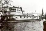 DONALD B (towboat) |
December 20, 1989 (#89002458) |
Ohio River[9] 40°01′16″N 80°44′17″W |
Bellaire | |
| 12 | Finney-Darrah House |  Finney-Darrah House |
March 15, 1982 (#82003546) |
Scenery Hill 40°06′02″N 80°44′22″W |
Martins Ferry | |
| 13 | Friends Boarding School and Ohio Yearly Meetinghouse Historic District | 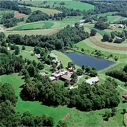 Friends Boarding School and Ohio Yearly Meetinghouse Historic District |
March 25, 2009 (#09000168) |
61830 Sandy Ridge Rd., east of Barnesville 39°59′18″N 81°09′09″W |
Warren Township | |
| 14 | Thomas T. and Wesley B. Frasier Houses | Thomas T. and Wesley B. Frasier Houses |
November 17, 1982 (#82001359) |
898 and 920 National Rd. 40°04′15″N 80°45′35″W |
Brookside | |
| 15 | George-Caldwell-Grum Farm |  George-Caldwell-Grum Farm |
February 14, 2018 (#100002118) |
Address Restricted |
Richland Township | |
| 16 | Great Western Schoolhouse |  Great Western Schoolhouse |
May 7, 1979 (#79001787) |
West of St. Clairsville on U.S. Route 40 40°04′22″N 80°58′52″W |
Richland Township | |
| 17 | Imperial Glass Company | 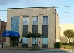 Imperial Glass Company |
September 8, 1983 (#83001945) |
29th and Belmont Sts. 40°00′41″N 80°44′49″W |
Bellaire | |
| 18 | James Kinney Farmstead | 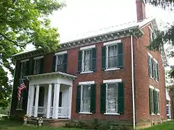 James Kinney Farmstead |
April 29, 1999 (#99000510) |
44680 Belmont-Centerville Rd., southeast of Belmont 39°59′50″N 80°59′38″W |
Smith Township | |
| 19 | Joseph Kirkwood House |  Joseph Kirkwood House |
February 13, 1986 (#86000239) |
329 Bennett St. 40°04′08″N 80°44′39″W |
Bridgeport | |
| 20 | Morristown Historic District |  Morristown Historic District |
March 6, 1980 (#80002943) |
Church, Main, W. Cross, E. Cross, and Middle Cross Sts. 40°03′51″N 81°04′22″W |
Morristown | |
| 21 | Opatrny Village Site |  Opatrny Village Site |
May 21, 1975 (#75001323) |
U.S. Route 40 north of the Belmont Hills Country Club[10] 40°04′29″N 80°56′36″W |
Richland Township | |
| 22 | Rock Hill Presbyterian Church |  Rock Hill Presbyterian Church |
April 1, 2009 (#09000169) |
56244 High Ridge Rd., northwest of Bellaire 40°02′15″N 80°46′22″W |
Pultney Township | |
| 23 | St. Clairsville Historic District |  St. Clairsville Historic District |
March 17, 1994 (#94000246) |
E. and W. Main St. between Butler and Sugar Sts. 40°04′50″N 80°54′02″W |
St. Clairsville | |
| 24 | Dr. Lindley Schooley House and Office |  Dr. Lindley Schooley House and Office |
April 1, 1982 (#82003545) |
Main St. 40°01′45″N 81°02′31″W |
Belmont | |
| 25 | Tower Site | 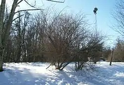 Tower Site |
June 11, 1982 (#82003544) |
On a hilltop 4 miles northwest of Barnesville[11] 40°01′23″N 81°13′16″W |
Warren Township | |
| 26 | Wheeling Island Historic District |  Wheeling Island Historic District |
April 2, 1992 (#92000320) |
Roughly bounded by Stone, Front, North, Ontario, Erie, and Wabash Sts. 40°04′50″N 80°44′15″W |
Bridgeport | Primarily located in Ohio County, West Virginia, but includes the Aetnaville Bridge, which is partially in Ohio |
| 27 | Zweig Building | 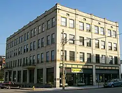 Zweig Building |
January 28, 2000 (#00000018) |
3396 Belmont St. 40°01′07″N 80°44′32″W |
Bellaire |
Former listing
| [3] | Name on the Register | Image | Date listed | Date removed | Location | City or town | Summary |
|---|---|---|---|---|---|---|---|
| 1 | Central School |  Central School |
July 23, 1979 (#79001786) | February 21, 1980 | Junction of Hickory and S. 4th Streets 40°05′41″N 80°43′31″W |
Martins Ferry | Destroyed |
See also
| Wikimedia Commons has media related to National Register of Historic Places in Belmont County, Ohio. |
References
- The latitude and longitude information provided in this table was derived originally from the National Register Information System, which has been found to be fairly accurate for about 99% of listings. Some locations in this table may have been corrected to current GPS standards.
- "National Register of Historic Places: Weekly List Actions". National Park Service, United States Department of the Interior. Retrieved on January 29, 2021.
- Numbers represent an alphabetical ordering by significant words. Various colorings, defined here, differentiate National Historic Landmarks and historic districts from other NRHP buildings, structures, sites or objects.
- "National Register Information System". National Register of Historic Places. National Park Service. April 24, 2008.
- The eight-digit number below each date is the number assigned to each location in the National Register Information System database, which can be viewed by clicking the number.
- Location derived from Swauger, James L. Rock Art of the Upper Ohio Valley. Graz: Akademische Druck und Verlagsanstalt, 1974, 115. The NRIS lists the site as "Address Restricted".
- Wright, D.K. (May 18, 2010). "Old Blaine Hill S-Bridge Makes National Register of Historic Places". The State Journal. Charleston, West Virginia: West Virginia Media Holdings, LLC. Archived from the original on July 25, 2011. Retrieved May 18, 2010.
- Pickenpaugh, Thomas E. "The Brokaw Site (33-Bl-6) — A Preliminary Report". Ohio Archaeologist 24 (1974): 40.
- Location derived from previous owner's website; the NRIS still lists the boat in Brown County.
- Gray and Pape. National Road/U.S. 40 Historic Properties Inventory in Ohio Archived 2014-02-21 at the Wayback Machine, Vol. 1. Columbus: Ohio Department of Transportation, 1998-07-02, 65.
- Location derived from Brown, Jeffrey D. The Tower Site and Ohio Monongahela. Kent: Kent State U, 1981, 3. The NRIS lists the site as "Address Restricted".
Municipalities and communities of Belmont County, Ohio, United States | ||
|---|---|---|
| Cities | Map of Ohio highlighting Belmont County | |
| Villages | ||
| Townships | ||
| CDPs | ||
| Unincorporated communities |
| |
| Ghost town | ||
| Footnotes | ‡This populated place also has portions in an adjacent county or counties | |
| ||
This article is issued from Wikipedia. The text is licensed under Creative Commons - Attribution - Sharealike. Additional terms may apply for the media files.