National Register of Historic Places listings in Logan County, Ohio
This is a list of the National Register of Historic Places listings in Logan County, Ohio.

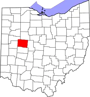
Location of Logan County in Ohio
This is intended to be a complete list of the properties and districts on the National Register of Historic Places in Logan County, Ohio, United States. The locations of National Register properties and districts for which the latitude and longitude coordinates are included below, may be seen in an online map.[1]
There are 10 properties and districts listed on the National Register in the county.
- This National Park Service list is complete through NPS recent listings posted January 29, 2021.[2]
Current listings
| [3] | Name on the Register[4] | Image | Date listed[5] | Location | City or town | Description |
|---|---|---|---|---|---|---|
| 1 | Downtown Bellefontaine Historic District |  Downtown Bellefontaine Historic District |
April 27, 2020 (#100005213) |
Roughly bounded by Elm St., Sandusky Ave., Madriver St., and Auburn Ave. 40°21′38″N 83°45′36″W |
Bellefontaine | |
| 2 | Dunns Pond Mound |  Dunns Pond Mound |
July 30, 1974 (#74001548) |
Junction of Mohawk and Mound Aves., northeast of Dunns Pond[6][7] 40°28′33″N 83°51′46″W |
Washington Township | A Hopewell burial mound |
| 3 | First Concrete Street in U.S. |  First Concrete Street in U.S. |
February 25, 1974 (#74001547) |
Court Avenue 40°21′37″N 83°45′33″W |
Bellefontaine | Only remaining portion of the first concrete pavement in the United States, built in 1891 |
| 4 | Lake Ridge Island Mounds |  Lake Ridge Island Mounds |
October 16, 1974 (#74001549) |
Western side of State Route 368 on Lake Ridge Island[7][8] 40°29′24″N 83°51′36″W |
Stokes Township | Group of small hills thought to be Native American mounds |
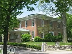
| 5 | William Lawrence House |  William Lawrence House |
August 24, 1979 (#79001884) |
325 N. Main St. 40°21′55″N 83°45′35″W |
Bellefontaine | Home of prominent politician William Lawrence |
| 6 | Logan County Courthouse |  Logan County Courthouse |
June 4, 1973 (#73001497) |
101 S. Main St.[9] 40°21′39″N 83°45′33″W |
Bellefontaine | Second Empire sandstone courthouse |
| 7 | Martin Marmon House |  Martin Marmon House |
February 20, 1986 (#86000322) |
County Road 153 near Zanesfield 40°19′40″N 83°40′00″W |
Jefferson Township | 1820 home of prominent Quaker pioneer |
| 8 | McColly Covered Bridge |  McColly Covered Bridge |
May 28, 1975 (#75001458) |
2 miles southeast of Bloom Center on County Road 13 40°24′03″N 83°55′27″W |
Washington Township | One of two remaining covered bridges in Logan County |
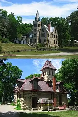
| 9 | Abram S. Piatt House and Donn S. Piatt House |  Abram S. Piatt House and Donn S. Piatt House |
May 3, 1982 (#82003604) |
Township Road 47 and State Route 245 (Mac-a-Cheek); County Road 1 and State Route 287 (Mac-o-Chee) 40°15′03″N 83°43′36″W |
Monroe Township | Gothic chateaux built by two brothers; commonly known as the Piatt Castles |
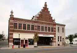
| 10 | Schine's Holland Theatre |  Schine's Holland Theatre |
May 25, 2001 (#01000561) |
125 E. Columbus St. 40°21′40″N 83°45′32″W |
Bellefontaine | Dutch Revival theater |
See also
| Wikimedia Commons has media related to National Register of Historic Places in Logan County, Ohio. |
References
- The latitude and longitude information provided in this table was derived originally from the National Register Information System, which has been found to be fairly accurate for about 99% of listings. Some locations in this table may have been corrected to current GPS standards.
- "National Register of Historic Places: Weekly List Actions". National Park Service, United States Department of the Interior. Retrieved on January 29, 2021.
- Numbers represent an alphabetical ordering by significant words. Various colorings, defined here, differentiate National Historic Landmarks and historic districts from other NRHP buildings, structures, sites or objects.
- "National Register Information System". National Register of Historic Places. National Park Service. March 13, 2009.
- The eight-digit number below each date is the number assigned to each location in the National Register Information System database, which can be viewed by clicking the number.
- Drennen, Bert C., III. National Register of Historic Places Inventory/Nomination: Dunns Pond Mound. National Park Service, 1974-01-22.
- Location derived from descriptions in nomination form and from USGS topographical maps; the specific address is restricted.
- Drennen, Bert C., III. National Register of Historic Places Inventory/Nomination: Lake Ridge Island Mounds. National Park Service, 1974-01-22.
- Address derived from this county website; the NRIS lists it as "Public Sq."
This article is issued from Wikipedia. The text is licensed under Creative Commons - Attribution - Sharealike. Additional terms may apply for the media files.

