National Register of Historic Places listings in Mobile County, Alabama
This is a list of the National Register of Historic Places listings in Mobile County, Alabama.
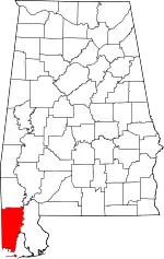
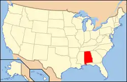
Location of Mobile County in Alabama
This is intended to be a complete list of the properties and districts on the National Register of Historic Places in Mobile County, Alabama, United States. Latitude and longitude coordinates are provided for many National Register properties and districts; these locations may be seen together in an online map.[1]
There are 138 properties and districts listed on the National Register in Mobile County, including 4 National Historic Landmarks. 114 of these sites, including all of the National Historic Landmarks, are located in Mobile, and are listed separately; the remaining 24 sites are listed here.
- This National Park Service list is complete through NPS recent listings posted February 5, 2021.[2]
Current listings
Mobile
Outside Mobile
| [3] | Name on the Register | Image | Date listed[4] | Location | City or town | Description |
|---|---|---|---|---|---|---|
| 1 | Hiram B. Austin House |  Hiram B. Austin House |
February 11, 1988 (#88000106) |
12995 Dauphin Island Pkwy. 30°25′12″N 88°06′17″W |
Mon Louis Island | |
| 2 | Barr's Subdivision Historic District |  Barr's Subdivision Historic District |
January 25, 1990 (#89002452) |
Roughly along U.S. 45 and Howard Ave. between LeBaron and State 31°05′33″N 88°14′20″W |
Citronelle | |
| 3 | Bellingrath Gardens and Home |  Bellingrath Gardens and Home |
October 19, 1982 (#82001609) |
South of Theodore off State Route 59 30°25′49″N 88°08′26″W |
Theodore | |
| 4 | Bishop Manor Estate | 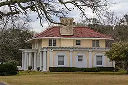 Bishop Manor Estate |
February 14, 1985 (#85000255) |
11570 Argyl Rd. 30°27′01″N 88°15′37″W |
St. Elmo | |
| 5 | Central Core Historic District | 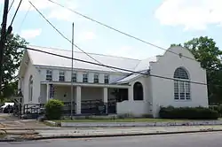 Central Core Historic District |
January 25, 1990 (#89002424) |
Roughly State St. and LeBaron Ave. from Mobile to 2nd Sts. 31°05′34″N 88°13′52″W |
Citronelle | |
| 6 | Chickasaw Shipyard Village Historic District |  Chickasaw Shipyard Village Historic District |
September 3, 2004 (#04000924) |
Bounded by Jefferson St., Jackson St., Yeend Ave., and Chickasaw Creek 30°45′49″N 88°04′28″W |
Chickasaw | |
| 7 | Citronelle Railroad Historic District | 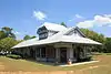 Citronelle Railroad Historic District |
January 25, 1990 (#89002421) |
Roughly Centre and Main from Union to Faye 31°05′14″N 88°13′39″W |
Citronelle | |
| 8 | Willis G. Clark House |  Willis G. Clark House |
January 25, 1990 (#89002454) |
East of U.S. Route 45 south of Citronelle 31°00′10″N 88°12′34″W |
Citronelle | |
| 9 | Davis-Oak Grove District |  Davis-Oak Grove District |
May 3, 1988 (#88000445) |
Western side of Oak Grove Rd. just north of Kali Oka Rd. 30°51′42″N 88°11′13″W |
Mauvilla | |
| 10 | Dauphin Island School | June 28, 2018 (#100001878) |
1300 Bienville Blvd. 30°15′12″N 88°07′11″W |
Dauphin Island | Demolished. | |
| 11 | Ellicott Stone |  Ellicott Stone |
April 11, 1973 (#73000359) |
1 mile south of Bucks off U.S. Route 43 30°59′52″N 88°01′21″W |
Bucks | |
| 12 | Fort Gaines |  Fort Gaines |
December 12, 1976 (#76000348) |
South of Mobile on the eastern end of Dauphin Island 30°14′54″N 88°04′32″W |
Dauphin Island | |
| 13 | Charles Denby Garrison Sr. House | September 9, 2009 (#09000693) |
County Road 55, approximately 1 mile northwest of its junction with State Route 158 30°48′54″N 88°07′58″W |
Prichard | ||
| 14 | Grand Bay Historic District | 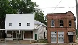 Grand Bay Historic District |
June 28, 1990 (#90000918) |
Junction of Dezauche Ln. and Freeland 30°28′34″N 88°20′32″W |
Grand Bay | |
| 15 | Indian Mound Park |  Indian Mound Park |
August 14, 1973 (#73000360) |
Off Cadillac Ave. on the northern side of Dauphin Island[5] 30°15′24″N 88°06′25″W |
Dauphin Island | |
| 16 | Isle Dauphine Club | Isle Dauphine Club |
January 31, 2017 (#16000815) |
100 Orleans Dr. 30°14′49″N 88°07′06″W |
Dauphin Island | |
| 17 | George Leatherbury House | June 14, 1990 (#90000917) |
Shell Belt Rd. southeast of Sans Souci Beach 30°22′47″N 88°15′04″W |
Coden | Destroyed by Hurricane Katrina | |
| 18 | Jacob Magee House | 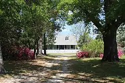 Jacob Magee House |
February 12, 1988 (#88000112) |
County Road 45 north of Kushla Mcleod Rd. 30°49′20″N 88°09′48″W |
Kushla | |
| 19 | Middle Bay Light |  Middle Bay Light |
December 30, 1974 (#74000429) |
Middle of Mobile Bay 30°26′18″N 88°00′40″W |
Mobile Bay | |
| 20 | Mount Vernon Arsenal-Searcy Hospital Complex |  Mount Vernon Arsenal-Searcy Hospital Complex |
May 26, 1988 (#88000676) |
Coy Smith Highway, ½ mile east of State Route 43 31°05′16″N 88°01′44″W |
Mt. Vernon | |
| 21 | Nanna Hubba Bluff | October 1, 1974 (#74000430) |
Overlooking the Tombigbee River in the northeastern corner of Mobile County[6] 31°09′25″N 87°58′34″W |
Calvert | Destroyed | |
| 22 | Old Mobile Site; Fort Louis De La Louisiane |  Old Mobile Site; Fort Louis De La Louisiane |
May 6, 1976 (#76000344) |
Twenty-Seven Mile Bluff on the Mobile River 30°58′01″N 87°59′32″W |
Le Moyne | |
| 23 | Tanner Farmhouse |  Tanner Farmhouse |
May 20, 2008 (#08000429) |
6885 Walter Tanner Rd. 30°50′07″N 88°21′51″W |
Wilmer | |
| 24 | N.Q. and Virginia M. Thompson House | 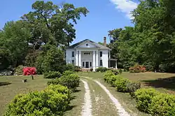 N.Q. and Virginia M. Thompson House |
January 25, 1990 (#89002453) |
7850 LeBaron Ave. 31°05′43″N 88°13′43″W |
Citronelle |
See also
| Wikimedia Commons has media related to National Register of Historic Places in Mobile County, Alabama. |
References
- The latitude and longitude information provided in this table was derived originally from the National Register Information System, which has been found to be fairly accurate for about 99% of listings. Some locations in this table may have been corrected to current GPS standards.
- "National Register of Historic Places: Weekly List Actions". National Park Service, United States Department of the Interior. Retrieved on February 5, 2021.
- Numbers represent an alphabetical ordering by significant words. Various colorings, defined here, differentiate National Historic Landmarks and historic districts from other NRHP buildings, structures, sites or objects.
- The eight-digit number below each date is the number assigned to each location in the National Register Information System database, which can be viewed by clicking the number.
- Location derived from its GNIS feature record; the NRIS lists the site as "Address Restricted"
- Location derived from its GNIS feature record; the NRIS lists the site as "Address Restricted"
Municipalities and communities of Mobile County, Alabama, United States | ||
|---|---|---|
| Cities | Map of Alabama highlighting Mobile County | |
| Towns | ||
| CDPs | ||
| Unincorporated communities | ||
| Ghost town | ||
| Indian reservation | ||
| Footnotes | ‡This populated place also has portions in an adjacent county or counties | |
| ||
This article is issued from Wikipedia. The text is licensed under Creative Commons - Attribution - Sharealike. Additional terms may apply for the media files.