National Register of Historic Places listings in Jefferson County, Alabama
This is intended to be a complete list of the properties and districts on the National Register of Historic Places in Jefferson County, Alabama, United States. Latitude and longitude coordinates are provided for many National Register properties and districts; these locations may be seen together in an online map.[1]
There are 171 properties and districts listed on the National Register in the county, including 3 National Historic Landmarks. 146 of these sites, including all of the National Historic Landmarks, are located in Birmingham, and are listed separately; another 26 sites are listed here. One district, the Red Mountain Suburbs Historic District, includes contributing properties located in the city of Birmingham and in adjacent parts of Jefferson County.
- This National Park Service list is complete through NPS recent listings posted January 29, 2021.[2]
Current listings
Birmingham
Outside Birmingham
| [3] | Name on the Register | Image | Date listed[4] | Location | City or town | Description |
|---|---|---|---|---|---|---|
| 1 | Jonathan W. Bass House | 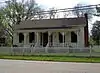 Jonathan W. Bass House |
May 21, 2008 (#08000456) |
1129 Montevallo Rd. 33°32′26″N 86°33′29″W |
Leeds | |
| 2 | Cahaba Homestead Village Historic District | Cahaba Homestead Village Historic District |
March 29, 2006 (#06000187) |
Approximately between Interstate 59 and U.S. Route 11 33°37′46″N 86°36′27″W |
Trussville | |
| 3 | Canaan Baptist Church | 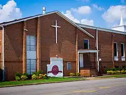 Canaan Baptist Church |
April 22, 2005 (#05000290) |
824 15th St., N. 33°24′06″N 86°57′51″W |
Bessemer | |
| 4 | Downtown Bessemer Historic District | July 15, 1992 (#92000852) |
Roughly bounded by 21st St., N., Carolina Ave., 19th St., N., 5th Ave., N. and the former Southern railroad tracks 33°24′08″N 86°57′05″W |
Bessemer | ||
| 5 | Dunbar High School |  Dunbar High School |
March 18, 2011 (#10001051) |
2715 6th Ave. N. 33°24′49″N 86°56′56″W |
Bessemer | |
| 6 | Five Mile Creek Bridge | February 28, 1973 (#73000350) |
1 mile northeast of McCalla off U.S. Route 11 33°20′52″N 87°01′21″W |
McCalla | ||
| 7 | Flintridge Building |  Flintridge Building |
June 2, 2004 (#04000560) |
6200 E.J. Oliver Boulevard 33°28′33″N 86°55′09″W |
Fairfield | |
| 8 | Hollywood Historic District | May 16, 2002 (#02000482) |
Roughly bounded by U.S. Routes 31 and 280 and Lakeshore Dr. 33°28′47″N 86°46′54″W |
Homewood | ||
| 9 | Leeds Downtown Historic District | 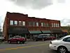 Leeds Downtown Historic District |
January 12, 1995 (#94001546) |
Roughly bounded by 9th St., NE., Thornton and Railroad Aves., and Parkway Dr., SE. 33°32′34″N 86°32′21″W |
Leeds | |
| 10 | Thomas McAdory House | 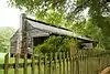 Thomas McAdory House |
December 26, 1972 (#72000161) |
214 Eastern Valley Rd. 33°22′28″N 86°57′42″W |
Bessemer | |
| 11 | Miles Memorial College Historic District | 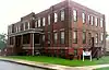 Miles Memorial College Historic District |
January 3, 1994 (#93001031) |
5501 Myron Massey Boulevard 33°28′53″N 86°54′28″W |
Fairfield | |
| 12 | Mountain Brook Estates Building | 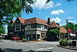 Mountain Brook Estates Building |
April 8, 2003 (#03000232) |
2803 Cahaba Rd. 33°29′02″N 86°46′24″W |
Mountain Brook | |
| 13 | Owen Plantation House | October 22, 1976 (#76000330) |
South of Bessemer on Eastern Valley Rd. 33°20′50″N 86°59′00″W |
Bessemer | ||
| 14 | Dr. Thomas McAdory Owen House | January 21, 1982 (#82002038) |
510 N. 18th St. 33°24′10″N 86°57′25″W |
Bessemer | ||
| 15 | Palmerdale Homesteads Historic District | November 21, 2019 (#100004642) |
Parts of Miles Springs, N. & S. Valley, Brookwood, Southfield N. & S., Midwood, Marsh Mountain & W. Hill Rds., Helms Cir. & AL 75 33°44′20″N 86°38′41″W |
|||
| 16 | Parham Apothecary Building | 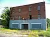 Parham Apothecary Building |
June 13, 1996 (#96000595) |
401 60th St. 33°28′41″N 86°54′48″W |
Fairfield | |
| 17 | Pinson Hills Historic District | .jpg.webp) Pinson Hills Historic District |
January 19, 2016 (#15000975) |
Roughly Cedar, Church, Main, Mountain, Pinson & Walnut Sts., Pinewood & Leslie Drs., Center Point & Silver Lake Rds. 33°41′29″N 86°40′43″W |
Pinson | |
| 18 | Pinson Main Street Historic District | .jpg.webp) Pinson Main Street Historic District |
January 19, 2016 (#15000976) |
Roughly Clayton, Lane, Main & Spring Sts., Elm & Powell Aves., Marvin's Way, Old Bradford Rd. & Pinson Plz. 33°41′23″N 86°41′08″W |
Pinson | |
| 19 | Red Mountain Suburbs Historic District | 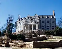 Red Mountain Suburbs Historic District |
October 3, 1985 (#85002719) |
Roughly bounded by Crest and Argyle and Altamont, Country Club, Salisbury, and Lanark Rds. 33°30′04″N 86°46′30″W |
Mountain Brook | Extends into Birmingham |
| 20 | Redmont Garden Apartments | August 5, 1993 (#93000761) |
2829 Thornhill Rd. 33°29′43″N 86°46′46″W |
Mountain Brook | ||
| 21 | Rosedale Historic District | 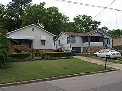 Rosedale Historic District |
March 31, 2004 (#04000236) |
Roughly bounded by 25th Court, S., Central Ave., 27th Court, S., Loveless/BM Montgomery St. 33°29′07″N 86°47′39″W |
Homewood | |
| 22 | Rosedale Park Historic District | 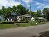 Rosedale Park Historic District |
March 31, 2004 (#04000235) |
Roughly bounded by Woodcrest Place, 26th Ave., S., 18th St., S., and 25th Ct., S. 33°29′16″N 86°47′23″W |
Homewood | |
| 23 | Sadler House | 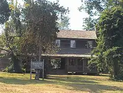 Sadler House |
April 23, 1975 (#75000315) |
3 miles south of McCalla on Eastern Valley Rd. 33°19′00″N 87°00′50″W |
McCalla | |
| 24 | Southern Railroad Depot | 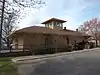 Southern Railroad Depot |
June 30, 1983 (#83002975) |
933 Thornton Ave., NE. 33°32′37″N 86°32′20″W |
Leeds | |
| 25 | Southern Railway Terminal Station | .jpg.webp) Southern Railway Terminal Station |
February 28, 1973 (#73000348) |
1905 Alabama Ave. 33°24′04″N 86°57′01″W |
Bessemer | |
| 26 | Tarrant City Downtown Historic District | April 26, 2010 (#09000105) |
Parts of E. Lake Blvd., Ford Ave., Jackson Blvd., Pinson St., Wharton Ave. 33°34′56″N 86°46′14″W |
Tarrant |
See also
| Wikimedia Commons has media related to National Register of Historic Places in Jefferson County, Alabama. |
References
- The latitude and longitude information provided in this table was derived originally from the National Register Information System, which has been found to be fairly accurate for about 99% of listings. Some locations in this table may have been corrected to current GPS standards.
- "National Register of Historic Places: Weekly List Actions". National Park Service, United States Department of the Interior. Retrieved on January 29, 2021.
- Numbers represent an alphabetical ordering by significant words. Various colorings, defined here, differentiate National Historic Landmarks and historic districts from other NRHP buildings, structures, sites or objects.
- The eight-digit number below each date is the number assigned to each location in the National Register Information System database, which can be viewed by clicking the number.
Municipalities and communities of Jefferson County, Alabama, United States | ||
|---|---|---|
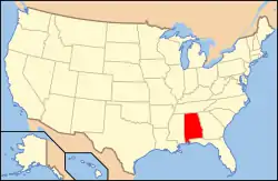
| Cities | Map of Alabama highlighting Jefferson County | |
| Towns | ||
| CDPs | ||
| Unincorporated communities | ||
| Former towns | ||
| Footnotes | ‡This populated place also has portions in an adjacent county or counties | |
| ||