National Register of Historic Places listings in Sumter County, Alabama
This is a list of the National Register of Historic Places listings in Sumter County, Alabama.
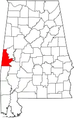
Location of Sumter County in Alabama
This is intended to be a complete list of the properties and districts on the National Register of Historic Places in Sumter County, Alabama, United States. Latitude and longitude coordinates are provided for many National Register properties and districts; these locations may be seen together in a Google map.[1]
There are 13 properties and districts listed on the National Register in the county.
- This National Park Service list is complete through NPS recent listings posted January 29, 2021.[2]
Current listings
| [3] | Name on the Register | Image | Date listed[4] | Location | City or town | Description |
|---|---|---|---|---|---|---|
| 1 | Dr. James Alvis Beavers House |  Dr. James Alvis Beavers House |
August 31, 2000 (#00001025) |
Old Livingston Rd. 32°26′20″N 88°21′43″W |
Cuba | |
| 2 | Coffin Shop | 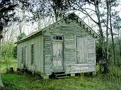 Coffin Shop |
October 29, 1985 (#85002930) |
McKee and Monroe Sts. 32°49′18″N 88°09′30″W |
Gainesville | |
| 3 | Colgin Hill | October 3, 1985 (#85002924) |
Off State Route 39 32°48′40″N 88°09′20″W |
Gainesville | ||
| 4 | Fort Tombecbee |  Fort Tombecbee |
October 2, 1973 (#73000373) |
Address Restricted |
Epes | |
| 5 | Gainesville Historic District | 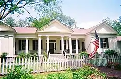 Gainesville Historic District |
October 3, 1985 (#85002925) |
Roughly bounded by North Carolina, Church, School, and Lafayette Sts., end of the town grid, and Webster St. 32°49′01″N 88°09′26″W |
Gainesville | |
| 6 | Gibbs House |  Gibbs House |
October 3, 1985 (#85002926) |
Southwest of Spruce and Webster Sts. 32°48′47″N 88°09′53″W |
Gainesville | |
| 7 | Main–Yankee Street Historic District |  Main–Yankee Street Historic District |
October 3, 1985 (#85002927) |
Roughly bounded by Main, Washington, and School Sts. 32°49′21″N 88°09′21″W |
Gainesville | |
| 8 | Col. Green G. Mobley House |  Col. Green G. Mobley House |
January 18, 1982 (#82002070) |
Webster and Pearl Sts. 32°49′06″N 88°09′38″W |
Gainesville | |
| 9 | Oakhurst |  Oakhurst |
January 6, 1987 (#86003563) |
Gainesville-Lacy's Ford Rd., approximately 3 mi (4.8 km) southwest of State Route 116 32°46′48″N 88°16′09″W |
Emelle | |
| 10 | Park and Bandstand | October 29, 1985 (#85002929) |
State and McKee Sts. 32°49′22″N 88°09′30″W |
Gainesville | ||
| 11 | Sumter County Courthouse |  Sumter County Courthouse |
March 24, 1972 (#72000180) |
U.S. Route 11 32°34′58″N 88°11′18″W |
Livingston | |
| 12 | Dr. H. B. Ward House | August 14, 1998 (#98001020) |
202 4th Ave. 32°25′42″N 88°22′33″W |
Cuba | ||
| 13 | Laura Watson House | October 3, 1985 (#85002928) |
Epes Rd. 32°48′52″N 88°09′11″W |
Gainesville | Building no more existing. |
See also
| Wikimedia Commons has media related to National Register of Historic Places in Sumter County, Alabama. |
References
- The latitude and longitude information provided in this table was derived originally from the National Register Information System, which has been found to be fairly accurate for about 99% of listings. Some locations in this table may have been corrected to current GPS standards.
- "National Register of Historic Places: Weekly List Actions". National Park Service, United States Department of the Interior. Retrieved on January 29, 2021.
- Numbers represent an alphabetical ordering by significant words. Various colorings, defined here, differentiate National Historic Landmarks and historic districts from other NRHP buildings, structures, sites or objects.
- The eight-digit number below each date is the number assigned to each location in the National Register Information System database, which can be viewed by clicking the number.
Municipalities and communities of Sumter County, Alabama, United States | ||
|---|---|---|
| Cities | Map of Alabama highlighting Sumter County | |
| Towns | ||
| CDPs | ||
| Unincorporated communities | ||
| ||
This article is issued from Wikipedia. The text is licensed under Creative Commons - Attribution - Sharealike. Additional terms may apply for the media files.